

Providing premium #precisionag services to farmers via our global network of #SWATMAPS service providers.
Canada
Joined August 2016
- Tweets3.9K
- Following391
- Followers2.4K
- Likes5.3K







Pinned Tweet
Start your 2027 planning at no cost. Your first field is FREE!
SWAT MAPS helps farmers achieve the highest level of precision management by turning field data into economic intelligence, so they can invest with confidence and improve profitability acre by acre.
We're offering complimentary services on a field up to 160 acres, which includes:
✅ SWAT BOX and RTK mapping
✅ SWAT MAPS creation
✅ Ground truthing
✅ SWAT Zone sampling
✅ VR recommendations and prescriptions
*Must have capable VR controller and equipment.
Get in touch to map your first field ➡️ bit.ly/3TAcwew

Not every acre has the same potential, the same limitations, or the same opportunity to return another dollar of input.
When you manage the whole field to one average, you risk:
🔸 Over-investing where the return isn’t there
🔸 Under-investing where there’s more potential
🔸 Missing the real reason performance varies
SWAT MAPS helps break the field down zone by zone so management can match what each area can actually produce.

95
Hey Red Deer! 👋
We’re headed to @agritradetoday, Nov 11–13, and we’d love to see you there!
Swing by Booth 473 in the Prairie Pavilion to meet our team and chat about how SWAT MAPS helps identify where fertilizer investment can generate the best return.
#abag #agritrade #alberta #SWATMAPS

1
108
Field variability isn't the problem. It's what you do with it that matters.
Every field has areas with different yield potential, soil characteristics, and input requirements.
The opportunity? Turn those differences into an economic advantage.
SWAT MAPS helps you understand where to invest more, where to pull back, and how to allocate inputs based on each zone's potential.
Precision ag isn't just about managing variability. It's about turning field variability into a smarter, more profitable management strategy.
Precision that pays, confidence that counts.

SWAT MAPS retweeted

📊 Years of farm data sitting in a folder? Dr. Phillip Harder of @swatmaps shows how to turn it into decisions you can act on at the 2027 Soil Health Conference.
📆 Feb 10–11 | Regina
🐦 Early bird ends Oct 31.
🔗 sasksoil.ca/event/soil-healt…
#SoilHealth2027 #SaskAg #PrecisionAg


SWAT MAPS retweeted

Agriculture is evolving.
@swatmaps partnered with Amii to tackle two major farming challenges: automating crop counts and mapping field conditions. See how custom AI models turn complex agricultural data into higher yields and reduced costs:
amii.ca/case-studies/growing…
#AgTech

🌱Nitrous oxide (N2O) is a potent greenhouse gas, with agricultural emissions closely linked to nitrogen fertilizer use. Importantly, nitrogen lost as N2O is also nitrogen that is no longer available to the crop, thus reducing nitrogen use efficiency.
Croptimistic is proud to be an industry collaborator with the Canadian Nitrous Oxide Network (CanN2ONet). This NSERC-funded national research network brings together researchers, industry, government, and producer groups from across Canada to develop practical solutions for reducing nitrogen losses from agriculture, including N2O emissions.
At CanN2ONet’s Olds College benchmark site, we’re working with a national research team led by @uofg to investigate whether variable rate nitrogen application can reduce N2O emissions while improving nitrogen use efficiency. Croptimistic provides SWAT MAPS zones, soil sampling, variable-rate prescriptions, and precision agriculture expertise, while the research team measures how these management practices affect the field.
Putting the right rate in the right place is good agronomy and smart economics. We’re excited to help demonstrate that it can also be good climate practice.
#sustainablefarming


Sticking with what you’re doing can feel like the lowest-risk option.
No learning curve, no additional expense, no need to change anything.
But there’s a hidden cost to average management, and that cost gets greater every year your margins get tighter.
It can look like:
🔸 Applying the same fertilizer rate to acres with very different potential.
🔸 Pushing low areas harder only to increase lodging risk.
🔸 Holding back productive areas that could have supported more.
🔸 Putting expensive inputs into areas that are unlikely to return the investment.
🔸 Repeating the same decisions next year without clearly understanding what worked and what didn’t.
Across thousands of fields, farmers are using SWAT MAPS to make those decisions with more precision, and seeing approximately 6:1 ROI (reported by the farmers themselves).
For many farmers, the value isn’t simply about cutting costs.
It’s knowing where to spend, where not to spend, and where there may be more potential to capture.
Book your first field for FREE and we’ll show you where potential opportunity may exist on one of your fields.

1
151
SWAT MAPS retweeted
Canadian farmers need every advantage. To help them stay ahead, Amii partnered with @swatmaps to harness AI for early-season crop detection—turning data into precise, time-saving field insights that protect yields and strengthen our food supply. 🌾
🎥: ow.ly/TeM750ZSpgw
The most progressive farms in the world trust SWAT MAPS - because precision only matters if it leads to better decisions and better returns.
Today, SWAT MAPS is used across more than 4 million acres in 3 countries, with a 98% client acre retention rate and farmers reporting an average 6:1 ROI.
That’s what happens when field variability becomes something you can actually manage, measure, and improve.

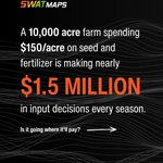
How confident are you that you’re putting millions of dollars of inputs in the right places?
On a 10,000-acre farm spending $150/acre on seed and fertilizer, that’s $1.5 million in input decisions every season.
The question isn’t whether you’re spending the money - you are regardless.
It’s whether you're putting your money where it has the best opportunity to provide a return.
SWAT MAPS helps you understand where to push, where to pull back, and where your input dollars have the best opportunity to pay.

2
191
Agronomic data tells you what happened in the field. Economic intelligence tells you what it means and why it matters.
❓What was the profit by zone?
❓What was the total income from the field?
❓What were the expenses by zone and across the field?
❓How many bushels were produced from each zone?
❓Which zones performed above or below target?
❓Where did additional investment actually create a return?
SWAT Analytics translates crop production performance into economic intelligence so you can see exactly what each zone in every field produced, what it cost, and what it returned.

1
139
Can precision agriculture help rebuild soil while protecting it from further erosion?
Our white paper, Driving Regenerative and Sustainable Agricultural Practices with Precision, explores this through a case study titled "Maintaining Soil Cover and Managing Phosphate to Reduce Erosion and Runoff."
In hummocky landscapes, eroded hilltops can lead to poor seed placement, low plant populations, and exposed soil that is vulnerable to further erosion. In our case study, variable rate seeding was used to increase crop establishment in vulnerable areas, while phosphate rates were adjusted by SWAT zone based on soil P supply and expected yield removal. The goal was to build ground cover, support soil health, and minimize excess phosphate and runoff.
🌱THE RESULT: Over time, increased crop roots and biomass can improve soil health and reduce seedling mortality, allowing seeding rates to eventually return to normal. This is a practical example of using field specific data to improve crop establishment while protecting soil.
Read the full case study in our white paper here: bit.ly/4dmmWVD
#SWATMAPS #precisionag #regenerativeag

SWAT MAPS is heading to North Dakota!
We’re making our first appearance at Big Iron Farm and Construction Show in West Fargo next week from September 15th to 17th.
If you're in the area, stop by our booth (#718) to chat all things soil, data and precision agriculture, and learn how to expand your agronomic offerings as a SWAT MAPS partner.
#USAag #SWATMAPS #precisionag #NorthDakota #WestFargo

Learn more about Big Iron Farm and Construction Show: bigironfarmshow.com/

89
SWAT MAPS retweeted

We are grateful for the support from @AgriCanadian and be featured in their video. Thanks for the assistance provided to @swatmaps and our partners in advancing some innovative R&D projects to commercialization. youtu.be/2NFG8kXwhZ4?si=VFg4…

SWAT MAPS retweeted

Soil sampling has started! Classroom training on Tuesday, in-field training today and we are off to the races! If you see a @swatmaps truck in the field give us a wave or stop and say hi, these next 8 weeks are crucial to our success. #soilsampling #harvest26 #precisionag


We're heading to Farm Progress Show in Boone, IA!
From September 1-3, SWAT MAPS will be at booth 442 ready to chat with you about all things precision ag.
Are you an agronomist visiting the show? We'd love to meet you! Let's chat about our partnership opportunity that pairs your agronomy expertise with a premium, proven solution trusted by farmers worldwide.
#FPS26 #SWATMAPS #precisionag @FPShow

We're excited to share that SWAT CAM has won an AgTech Breakthrough Award for "Precision Agriculture Solution of the Year 2026"
This recognition highlights the innovation behind SWAT CAM and its role in making high-quality soil data more accessible and precise for farmers.
Learn more about SWAT CAM at hubs.la/Q04vpwdH0
Learn more about @AgTech_Awards at hubs.la/Q04vpydK0
#SWATCAM #precisionag
