
Adam Moore is an Emergency Manager with a Bachelor's from Millersville University and is currently pursuing his Master's. He works as an SAU Analyst with VDEM.
Virginia
Joined September 2015
- Tweets26.4K
- Following626
- Followers5.1K
- Likes5.2K




Pinned Tweet
Was able to capture the Partial Solar Eclipse in Sumerduck, VA this morning. #SolarEclipse #solareclipse2021 #vawx @capitalweather @StormHour @hbwx @spann @wxbrad

Special Weather Statement issued for Extreme Western Allegany through Eastern Pendleton. With temps near/below freezing overnight, patchy fog may form and some could turn to freezing fog, locally dense in spots; slick spots possible—use extra following distance if driving.

113
Freeze Warning for Carroll, Northern Baltimore, Cecil & Others from 12 AM EST Saturday through 8 AM EST Saturday. Sub-freezing temperatures as low as 31 expected.

86
Special Weather Statement issued for the District of Columbia and Prince Georges & Others this morning. Localized dense fog has dropped visibilities below 1/4 mile at times, causing sudden slowdowns while driving; use extreme caution, low beams, and leave extra distance/time.

1
142
Special Weather Statement is in effect for the District of Columbia, Prince Georges & Others this morning due to localized dense fog with visibilities dropping below 1/4 mile. Patchy but locally very dense—use extreme caution, slow down, and use low-beam headlights.

91
Freeze Warning issued for Nelson, Albemarle, Greene & Others from midnight tonight to 9 AM EST Sunday. Temps 28–32F expected, with coldest readings in sheltered valleys below 500 ft. Frost/freeze could kill crops and damage unprotected outdoor plumbing.

123
Frost Advisory for Rappahannock, Stafford, Spotsylvania & Others from 12 AM EST Sunday through 9 AM EST Sunday. Temperatures of 33 to 36 will result in frost formation.

120
A gale-force non-tropical low a few hundred miles south of Bermuda has disorganized convection and a 30% chance to develop subtropical characteristics in 48 hours, rising to 40% in 7 days.

107
Vibrant sunrise this morning in Williamsburg, VA. Worth the little detour on my way home from work. #vawx #sunrise #fall #weather @spann @capitalweather @FoliageReport @hbwx @MikeTFox5 @ChuckBell4 @dougkammerer


A broad low forming along a remnant front a few hundred miles south of Bermuda has a 30% chance to develop in 48 hours and a 50% chance in 7 days. Conditions may allow gradual subtropical characteristics through this weekend, then become unfavorable early next week.

115
Low pressure may form within 1 day a few hundred miles south of Bermuda, then slowly drift east. It has a 20% chance to develop in 48 hours and a 40% chance in 7 days, but conditions turn unfavorable by early next week.

218
Low pressure may form along a weakening front a few hundred miles south of Bermuda within a day, with 20% chance of development in 48 hours and 40% in 7 days. It could gain some subtropical traits late this week or weekend, then conditions turn unfavorable early next week.

141
Dense Fog Advisory is in effect for Warren, Rappahannock, and Northern Fauquier until 10 AM EDT this morning. Visibility may drop to 1/4 mile or less in dense fog, making driving hazardous.

Dense Fog Advisory is in effect for Extreme Western Allegany, Central and Eastern Allegany, & Others until 10 AM EDT this morning. Visibility may drop to 1/4 mile or less in dense fog, making driving hazardous.

131

A Frost Advisory has been issued for Fluvanna, Prince Edward, Cumberland, Goochland, Caroline, Nottoway, Amelia, Powhatan, Western Louisa, Eastern Louisa & Western Hanover until 9:00 AM EDT 10/26/26. Temps near 34°F may form frost; cover sensitive plants.

113
A Frost Advisory has been issued for Carroll, Northern Baltimore, Cecil, & Others in MD and VA from 1 AM to 9 AM EDT Monday. Temps near 33F may form frost, especially in valleys/low-lying areas; cover sensitive plants to prevent damage.

117
Frost Advisory has been issued for Central and Southeast Howard and Central and Southeast Montgomery Counties in MD and Orange, Spotsylvania, Fairfax, Stafford, and Madison Counties in VA until 9 AM EDT Sunday. Temps near 33F may form frost, harming uncovered plants.

266
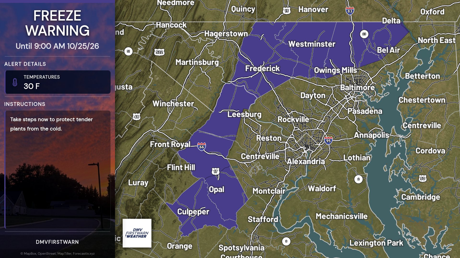
Freeze Warning has been issued for Frederick, Carroll, Northern Baltimore & Northwest Harford until 9 AM EDT Sunday. Sub-freezing temps as low as 30F may cause frost/freezing that can kill crops and damage unprotected outdoor plumbing.
120
Frost Advisory is in effect for Frederick, Carroll, Northern Baltimore & Others from 1 AM to 9 AM EDT Sunday, with temps down to 33F causing frost. Cover sensitive outdoor plants to prevent damage.

128
