

Earth Observation Specialists
Joined January 2020
- Tweets14
- Following46
- Followers21
- Likes7



AAT feature as a start up with cutting edge potential in INC's new Insurtech in Focus series.
insurtechcarlow.ie/blog/

Sentinel Imagery of Ireland, mosaic compiled during last week's clear weather. @ Ireland (country) instagram.com/p/B_POjV2FanN/…
A Simple Way to Forest Management
#forestmanagement #forestry #forestmanagementtechnology #forestanalytics #augmentedforestmanagement #forestryireland
👉instagram.com/tv/B94NXngJVrG…
AAT applications deliver the most accurate, accessible and comprehensive forest verification data. You'll receive granular, near real-time maps and forest specific reports of wind and fire disturbance.
Find out more at aerialagritech.ie/Forestry.p…


Aerial Agri Tech solution is integrating drone imagery into satellite remote sensing assessments of forestry management.
Our technology helps to get the best out of your forest management practices in managing forest wind and fire damage.
Discover 👉 aerialagritech.ie/Forestry.p…

Over the last 6 weeks the surface area of the River Shannon and Lough Drumharlow surrounding Carrick-On-Shannon have increased by 46% in surface area, covering approximately 368ha of agricultural/bog lands, while parts of the town itself are submerged.

Rubber and Palm oil side by side in Krabi province southern Thailand, tough times ahead for farmers with rubber prices plummeting and the EU phasing out the use of Palm oil over the coming years. @ Krabi, Thailand instagram.com/p/B8qp-juhHbf/…
1

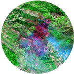
False Colour Composite, Fire caused by electrical fault displacing thousands in northern California, bright red depicts active fire

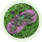
NIR satellite imagery of Bidi Bidi in North West Uganda. In 2016 thousands of refugees fled war torn South Sudan establishing a significant camp in rural Uganda during a period of drought. Today Bidi Bidi accommodates a quarter million people same population as Galway Co.

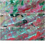
Small pockets of damage post storm Brendan in the midlands on heavily thinned poorly drained site. Aerial images show the site pre-storm


