

Certified broadcast meteorologist at @WPLGLocal10 in Miami, FL.
Miami, FL
Joined August 2018
- Tweets3.2K
- Following679
- Followers6.1K
- Likes2.8K





Another day of major king tide flooding across South Florida with saltwater flowing into homes and closing high traffic streets in Fort Lauderdale.
South Florida is in the middle of the highest king tides ever recorded here. This morning reached the same major flood stage as Hurricane Wilma in 2005 sending water down streets from Miami to Fort Lauderdale and even flowed into some homes and businesses that weren't sandbagged.
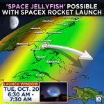
SpaceX changed its launch trajectory for their Falcon 9 rocket and it could put on an even better show for Florida and the Bahamas! Look out for the one hour launch window that begins at 6:30am Tuesday.


No surprise, it's raining for @CanesFootball @FSUFootball at Hard Rock Stadium in Miami Gardens tonight. Hopefully we can keep the lightning away😬


A Flash Flood Warning continues for parts of Broward and Palm Beach Counties in Florida until 5:15pm Saturday. This includes areas near Parkland, Coral Springs, and Coconut Creek. A stationary thunderstorm has dropped 3-5" of rain and isn't showing signs of letting up.


Brandon Orr retweeted

SE 10th street by S Dixie Highway in Deerfield Beach is flooded, and some areas are around a foot deep of water! Avoid flooded roads today!
#flwx @NWSMiami @FLStormChasers_ @BrandonOrrWPLG @DylanFedericoWX @MattDevittWX
Brandon Orr retweeted

🚨 EXTENSIVE STORM SURGE DAMAGE – PENSACOLA BEACH, FL! 🌊⚠️
The aftermath of Hurricane Isaias is incredible across Pensacola Beach, Florida! Thick layers of sand cover many roads after powerful storm surge pushed water and debris inland. Damaged homes, missing roofs, partially collapsed structures, half-sunken boats, downed power lines, and scattered debris paint a devastating picture of the hurricane's impacts. Evidence of significant coastal flooding can be seen throughout the area.
🎥 Footage available for media licensing: [email protected]
#HurricaneIsaias #StormSurge #PensacolaBeach #HurricaneAftermath #Florida
Hurricane Isaias is now a dangerous CAT 3 with 120mph winds. We’re back after flying into the eye of Hurricane Isaias 5 times over the span of 8 hours with NOAA’s Hurricane Hunters. Comparing the changes with each pass is pretty important to see these changes.
Eye of Hurricane Isaias not looking very circular and open on the south side around noon Thursday. Four hours later, we had a closed eyewall and intensity up to 100mph (CAT 2). Less tilted too. Gradual organization continues tonight.
About to go up with NOAA Hurricane hunters this afternoon to fly into Hurricane Isaias in the Gulf. It’s right on the cusp of rapid intensification.
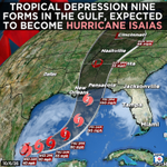
A developing tropical system in the Gulf is likely to become Hurricane Isaias later this week. Expected to pack winds of 100mph, it could make landfall late Friday into early Saturday. Severe weather including tornadoes will also be big impacts along the northern Gulf coast.

There could soon be a tropical storm or even a hurricane in the Gulf with a landfall over the weekend. Here's what we know so far...

It happened AGAIN. After the wettest September ever recorded in Fort Lauderdale, the first day of October comes with another round of flooding.
A Flood Warning continues for Key West until 6:15pm. Up to 5” of rain has fallen so far leading to numerous flooded roads. Some businesses have put up sandbags to keep the water out.
A powerful coastal storm moving up the East Coast is sending swells down to Florida. At the same time, the full moon is giving us a round of king tides. This ugly combo sent waves up to the buildings on Hollywood Beach this morning.
☀️ Florida's first front of the season will bring 50s for some. Miami will drop to the low 70s with lower humidity, which is the coolest in nearly 5 months!
🤖 Made with AI
