

Geologist at the National Oceanography Centre, Southampton, UK researching submarine landslides, turbidity currents and volcanic islands
Southampton UK
Joined January 2015
- Tweets81
- Following69
- Followers167
- Likes36


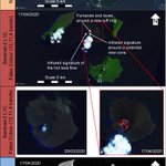




Another sneak-peek at some of the satellite images used in our @NatureComms paper of the 2018 Anak Krakatau landslide. Half of the island including the edifice failed into the caldera basin @NOCnews

5
A sneak-peek at some of the results from our @NatureComms paper on the 2018 Anak Krakatau landslide. The collapse of the SW flank on December 22nd deposited 90-high blocks in a series of block trains over 1.5 km from the flank @NOCnews

Happy to announce our paper on the 2018 Anak Krakatau flank collapse in @NatureComms has gone live this morning. Here, we show that half the island collapsed to generate the tsunami and reveal the landslide deposit on the seafloor for the first time nature.com/articles/s41467-0…

@NatureComms have provided a shortened URL for our paper as part of their SharedIt initiative rdcu.be/ckCl8 😀
2
Recent Sentinel-2 images and Sentinel-1 SAR of Anak Krakatau on the 17th, showing new lavas, ejecta, crater disappearance and potential cone development. The rapid rebuild continues. #NERCscience

Great image from the OLI on Landsat 8 published by NASA with an infra-red overlay showing the activity at Anak Krakatau on the 13th #NERCscience

Anak Krakatau made an explosive return on the 10-11th and 13th April. Here, are satellite true-colour images from Sentinel-2 and SAR (radar) images from Sentinel-1 during the episode. The crater lake seems to have disappeared. Interesting developments since the 2018 landslide.

James Hunt retweeted

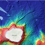
#FunFact - The 8 main Hawaiian Islands are made up of 15 volcanoes, which are the youngest in a chain of more than 129 volcanoes (above and below sea level) that stretches for ~3,800 mi - volcanoes.usgs.gov/observato…

The next riddle after multistage landslides...Do these most recent deposits offshore SW Montserrat record the 1997 and 2010 flows and surges that buried Plymouth and entered the sea? @MikeVolc

The geological scenario in our paper (rdcu.be/EZUJ) has been taken out of context @Daily_Star @JoshuaNevett. Ocean island landslides may trigger caldera collapse eruptions, but these events are v v rare, occurring every 250,000 years or more; certainly not historical.
I would urge journalists (e.g. @JoshuaNevett @Daily_Star ) to approach the authors of research for informed advice concerning their work before copy-pasting exerts of press releases to fit their stories grandstanding catastrophism. There is a need for responsible reporting.
James Hunt retweeted

Oh no, not again! How is it that this ridiculous story about a Canary Islands megatsunami keeps reappearing? dailystar.co.uk/news/latest-… For a more balanced view: blogs.agu.org/landslideblog/… and blogs.agu.org/landslideblog/…
James Hunt retweeted

gosh - they have conflated three different things (tsunami modelling based on v worst case, prob not credible scenario), recent (possibly) increased but small seismic activity, and long-term volcanic island evolution (tie between very rare flank collapse and eruptions)
James Hunt retweeted

Large volcanic island flank collapses trigger catastrophic eruptions sco.lt/7zB1JB @NOCnews

James Hunt retweeted

Short clip of our @NERCscience ATSC students logging turbidites cores, learning how to use the handheld photospectrometer and making smear slides ready for tomorrow’s practical.
Research published today in @Nature by @MikeVolc and I show that giant landslides on Tenerife e.g. the Icod and Orotava (pictured) likely triggered huge caldera-forming eruptions. Source: rdcu.be/EZUJ
