

Boston area meteorologist trying to help jittery fliers while watching the sunset.
Boston
Joined November 2012
- Tweets14.5K
- Following2.2K
- Followers1.9K
- Likes24.9K
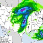


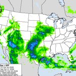


The next 24 hours QPF from the WPC and the SPC with a Level 2 severe storm threat from TX up to KS/MO.


The next 24 hours per the HRRR model features a storm over the Plains with an active cold front down to TX & some backside snow for eastern WY & a tropical wave moving through FL.
Expect some moderate turbulence at cruising-level today from OH south to FL, over the western Gt Lakes & adjacent states, over a portion of MT & ND & over the Southwest 4 Corners states.

Today's rainfall to 7am on Saturday on the HRRR and WPC's totals. Two separate areas, one centered on AZ with a tropical feed and the other through south & west TX up to the Midwest.


This morning's significant cruising-level turbulence features an arc from TX over much of the South to FL & an additional area over WA which is much more extensive into Canada (not shown).


If you are flying this morning, it looks like a pretty good ride with no identified areas of cruising-level turbulence, only some low-level wind shear in a few spots of the Plains, Rockies and Pac NW.

For fliers this morning, expect some moderate turbulence over parts of New England, the Midwest from NB to MN and the Rockies from UT/CO to ID/MT. Note that there is also a Severe Turb Sigmet over parts of CO, WY into MT.

Today's HRRR model shows areas of rain and snow along the northern tier boarder region from WA to the UP of MI, some showers over part of the Midwest and showers over South FL.
Today's HRRR model shows a storm moving over the Northern Plains with a trailing cold front down to TX, another system moves into the Pac NW and reforms over MT while a disturbed area lurks over the Bahamas.
Several areas of moderate turbulence this morning off the East Coast, from TX to MS, Rockies into Plains and WA to NV. In addition, a Severe Turbulence Sigmet over part of the western Atlantic.


Today's HRRR model shows TS Josephine moving out to sea and numerous showers and thunderstorms over the West.
The SPC has much of AZ into NM in a level 2 threat zone while the WPC has much of the Four Corner states in threat zones for excessive rainfall today.


Significant cruising-level turbulence this morning is expected over much of New England and offshore plus parts of the West and Southwest. In addition, many areas of convective activity over the Southwest.

