

We are a dedicated weather team based in Cornwall, UK. You can find us on facebook by searching for Kernow Weather Team or Instagram and TikToK
Cornwall, South West, England
Joined February 2017
- Tweets72.5K
- Following342
- Followers5.1K
- Likes36.2K




Pinned Tweet
KWT COMES TO YOU. HELP US TAKE THE NEXT BIG STEP!
For years, we've brought Cornwall's weather to your screens. Now we want to bring KWT into your schools, communities and local events!
We're raising £20,000 to create a mobile weather education setup, complete with forecasting equipment, interactive displays, educational resources and everything needed to make learning about the weather fun for all ages!
And we don't need to reach £20,000 to get started. Every donation helps us build the project piece by piece.
Imagine if just a small percentage of our amazing followers donated £1!
Can't donate? A simple share helps enormously too.
Support our Crowdfunder:
crowdfunder.co.uk/p/kwt-come…
Together, we can take KWT from the screen and into the heart of Cornwall!
From Moor to Shore, there is only one of us for all of you!
Thank you from everyone at KWT!

Good morning, everyone!
Here are the latest temperatures recorded across Cornwall and the Isles of Scilly, and there's certainly a spooky chill in the air!
Parts of East Cornwall are waking up to a rather bone-chilling 2–4°C, while temperatures across Cornwall and the Isles of Scilly are generally ranging from 3°C to 13°C.
Quite a difference across our little corner of the world!
Perhaps the witches have left the freezer door open, or maybe Dracula has turned the heating down to save on his electricity bill!
Whatever you're doing this Halloween, wrap up warm if you're heading out early, and watch out for those mysterious patches of mist lurking in the valleys!
And remember, if you hear something going bump in the night, don't worry... It's probably just Gus raiding the cat treats again!
Have a spooktacular Halloween, everyone! 🎃
Kind regards,
KWT Dave.
#KernowWeatherTeam #CornwallWeather #HappyHalloween #SmudgeAndGus
Kernow Weather Team retweeted

@KWTWeather CORNWALL at 0750 UTC. EUMETSAT. Looking better this morn' Dave...

Kernow Weather Team retweeted
@KWTWeather CORNWALL at 0750 UTC. EUMETSAT. Dunno Dave, looks urky-murky down there...

Kernow Weather Team retweeted
METOP-B, 0924 UTC Overpass: UK and IRELAND. @Petagna @Mark__Bowe @SqRaindrop @HIOWweather1 @KWTWeather @BlackCountryWX

Good morning everyone, and happy wonky Wednesday!
Well, would you believe it? After two named storms, the remnants of former Tropical Storm Josephine, plenty of rain and enough tightly packed isobars to give me a headache, it looks like the Atlantic might finally be taking a well-earned break!
And I've got some rather good news for you this morning!
High pressure is expected to build towards Cornwall from France over the next couple of days, bringing the possibility of a much quieter and more settled spell of weather from Thursday through to at least Sunday.
And yes, Halloween is currently looking reasonably promising too!
We might even get some spooky mist and fog developing, which would certainly add a bit of atmosphere to Halloween evening!
But first, what has Wednesday got in store for us?
WEDNESDAY MORNING
We're starting the day with a fairly typical mixture of autumn weather across Cornwall and the Isles of Scilly.
There will be some lovely bright and sunny spells, plenty of passing cloud and a few showers dotted around.
However, the good news is that most places should remain dry for much of the morning.
Temperatures will generally be around 7–14°C, depending on your location, WEDNESDAY AFTERNOON
As we head through the afternoon, it will be another case of the Cornish weather lottery!
Some locations will enjoy some lovely autumnal sunshine, while others could catch a passing shower.
And you can almost guarantee that the moment you put the washing outside, one lonely rain cloud will appear directly above your garden!
By mid-afternoon, cloud is expected to increase from the southwest, although there should still be a few brighter spells around.
Afternoon temperatures will reach around 9–15°C.
WEDNESDAY EVENING
As we head into the evening, skies are likely to become rather cloudy across much of Cornwall.
There could still be a few scattered showers, but many places should remain dry.
Temperatures will gradually fall towards 8–13°C.
💨 WHAT ABOUT THE WINDS?
Thankfully, we're not expecting anything like the powerful winds we've experienced recently!
Winds will generally come from the southwest at around 10–30 mph, with the strongest breezes around exposed coastal areas and higher ground.
Hopefully, the wheelie bins have finally finished their tour of Cornwall and returned home!
🌤️ A QUICK LOOK AT THURSDAY & HALLOWEEN!
Thursday should see high pressure becoming more influential, with a mixture of cloud, bright spells and some sunshine.
There could also be patches of hill and coastal mist, with winds turning towards the southeast.
Temperatures could reach a rather pleasant 12–17°C.
Looking further ahead, Friday through Sunday currently appears more settled, although high pressure doesn't always guarantee sunshine. We could still see plenty of cloud and some mist or fog.
But at the moment, Halloween looks more likely to bring spooky mist than howling Atlantic winds!
🐾 SMUDGE & GUS WEATHER VERDICT!
🐱 Smudge: "Less wind and fewer showers? Excellent! I can finally get back to some serious sleeping!"
🐈 Gus: "Halloween fog is fine, but I'm not dressing up as a pumpkin. You've been warned!"
A LITTLE NOTE FROM KWT HQ
We've got our very own mini meteorologist Poppy joining us today, so there might be slightly fewer weather updates than normal.
Although, knowing Poppy, she'll probably have taken over the weather charts and be running KWT HQ before lunchtime!
We'll still be keeping an eye on everything, especially if anything important develops.
So, all in all, Wednesday isn't looking too bad, and there's finally some hope of a quieter spell of weather ahead!
Have a fantastic Wednesday, everyone, and enjoy those sunny spells if you manage to catch them!
Kind regards,
KWT Dave
From moor to shore, we've got Cornwall covered.

#Cornwall #Surf reports
Well, Wednesday is here, and after several days of wild Atlantic weather, things are finally starting to improve!
There's still plenty of swell rolling into Cornwall, but the winds should become more favourable as the day progresses. The Atlantic washing machine might finally be coming off its spin cycle!
SWELL & WIND
Main Atlantic swell: 7–10ft from the W at 11–13 seconds, gradually easing towards 5–7ft later.
Exposed beaches are seeing mainly SW to WSW winds around 10–20mph this morning, with easterly S to SE winds possible later.
Conditions should gradually improve, although some beaches remain choppy early on. Swell & Tide +2
#NEWQUAY & NORTH CORNWALL
#Fistral: 6–9ft, powerful surf with improving potential later.
#Crantock: 5–8ft, initially textured.
#Holywell Bay: 6–9ft, powerful sets.
#Perranporth: 6–8ft, some cleaner waves possible later.
#Watergate Bay: 6–9ft, still plenty of Atlantic energy.
#Mawgan Porth: 5–8ft, improving if winds ease.
#Polzeath: 4–7ft, with some shelter.
#Harlyn: 3–5ft, potentially a more manageable option.
#Towan and Great Western: 2–4ft, smaller sheltered waves.
GWITHIAN, GODREVY & ST IVES
#Gwithian: 3–5ft.
#Godrevy: 4–6ft.
#Porthtowan: 6–9ft, powerful surf.
#Chapel Porth: 6–9ft.
#Porthmeor: 3–5ft, potentially cleaner later.
#Hayle and Mexico Towans: 2–4ft each.
Some exposed beaches remain messy this morning, so check conditions before heading in. Barrel Monkey +2
WEST CORNWALL
#Sennen: 5–7ft.
#Gwenver: 6–8ft, potentially heavier sets.
A decent amount of swell remains, with conditions improving as the wind settles.
🌊 SOUTH CORNWALL
#Praa Sands: 3–5ft, rather mixed conditions.
#Porthleven: 3–5ft, wind-affected and suitable for experienced surfers only.
All beach heights are estimated breaking surf, not offshore swell measurements.
BEST SURF WINDOWS
Morning, 08:00–11:30: Powerful surf, with some wind interference.
Afternoon, 13:00–16:30: Potentially the better opportunity as swell eases and winds become more favourable.
Best areas to check: Fistral, Perranporth, Sennen and suitable sheltered breaks.
SEA TEMPERATURE
Around 15°C. A 4/3mm wetsuit is recommended.
NEWQUAY TIDES
Low: 00:08
High: 05:56
Low: 12:28
High: 18:18
Spring tides continue, with a substantial tidal range. Newquay Tides +1
⭐ OCEANIC-WAVE VERDICT
North coast: ⭐⭐⭐☆☆
West Cornwall: ⭐⭐⭐☆☆
South coast: ⭐⭐☆☆☆
Best suited to experienced and confident intermediate surfers. Beginners should seek smaller, supervised conditions.
SEA SAFETY
Powerful swell and spring tides can create strong rip currents. Check local conditions and lifeguard coverage before entering the water.
Have a cracking Wednesday, everyone! Stay safe and enjoy those Cornish waves! 🌊
Oceanic-Wave: From Cornwall's coastline to the open ocean.

Kernow Weather Team retweeted
METOP-C, 1007 UTC Overpass: UK and IRELAND. @Petagna @Mark__Bowe @SqRaindrop @HIOWweather1 @BlackCountryWX @KWTWeather

DID YOU KNOW YOUR TOILET CAN REACT TO THE WEATHER? YES, REALLY!
Good morning, everyone!
Now, this is probably going to be one of the strangest weather posts I've written for KWT, but bear with me because there's actually some fascinating science behind it!
Did you know that changes in atmospheric pressure can sometimes affect the water level in your toilet? And during stormy weather, you might even notice little ripples appearing on the surface!
Yes, we're talking about toilet weather forecasting this morning!
SO, HOW DOES IT WORK?
When a deep area of low pressure moves across Cornwall, the atmospheric pressure around us drops.
Air pressure is simply the weight of the atmosphere pressing down on everything around us, including water.
In theory, changes in atmospheric pressure can influence water levels, especially where water is connected to enclosed air spaces or drainage systems.
However, here's the interesting bit!
Your toilet is connected to a network of pipes and drains, and changes in air pressure within those pipes can sometimes cause the water in the bowl to move slightly.
During stormy weather, strong winds blowing across roof vents can also create pressure differences in the drainage system.
This can occasionally cause the water to ripple, wobble or even change level a little!
BUT DOES LOW PRESSURE ALWAYS MAKE TOILET WATER RISE?
Not necessarily!
Although falling atmospheric pressure can contribute to pressure differences, it doesn't automatically make toilet water rise, and high pressure doesn't always make it fall.
In most homes, the water level is controlled by the shape of the toilet's internal trap, and any noticeable movement is more likely to involve pressure changes within the plumbing system.
And here's another fascinating fact!
During heavy rainfall, drainage systems can become overloaded, which may also affect water levels or cause gurgling in some toilets.
So if you've noticed your toilet water behaving strangely during one of our recent Atlantic storms, there could actually be a scientific explanation!
AND WHAT ABOUT THOSE LITTLE WAVES?
Yes, tiny ripples can sometimes appear on the surface if air pressure fluctuates inside the drainage pipes or vibrations travel through the plumbing.
But before anyone starts blaming Storm Austen for turning their toilet into Fistral Beach, remember that flushing elsewhere in the house or plumbing issues can produce similar effects!
If your toilet regularly gurgles, the water level changes dramatically, or wastewater starts backing up, that's something to get checked rather than putting it down to the weather.
SO THERE YOU HAVE IT!
We've covered thunderstorms, jet streams, hurricanes, atmospheric pressure and now we've officially reached toilet meteorology!
At this rate, I'll be installing a weather station next to the loo at KWT HQ!
And if you happen to notice tiny waves in your toilet during the next storm, please don't get the surfboard out. That's definitely one location Oceanic-Wave won't be adding to its daily surf reports!
Have a fantastic morning, everyone, and remember, weather science can turn up in the strangest places!
Kind regards,
KWT Dave
From moor to shore, we've got Cornwall covered apparently even the bathroom!
Kernow Weather Team retweeted
@KWTWeather CORNWALL at 0800 UTC. EUMETSAT. That's Dave down there leaping about with joy because the front passed through...

🎃👻 HALLOWEEN WEATHER OUTLOOK: WILL IT BE A TRICK OR A TREAT? 🦇🌫️
With Halloween creeping ever closer, it's time to dust off those broomsticks, wake up the skeletons and see what Mother Nature has brewing in her weather cauldron!
Will Cornwall be haunted by ghostly rain, battered by spooky winds, or will the weather gods give us a little Halloween treat?
Well, looking at the latest weather models, Halloween is actually looking rather promising at the moment! And after all the wild weather we've had recently, that's certainly a treat rather than a trick!
An area of high pressure looks set to build towards the end of the week, which should help calm things down across Cornwall and the Isles of Scilly.
The winds are expected to become much lighter, generally coming from a southeasterly direction, so hopefully no witches getting blown off their broomsticks this year! 🧹
But here's where things could get a little spooky!
As Halloween evening arrives, temperatures are likely to fall, bringing a rather chilly feel for anyone heading out trick-or-treating.
And with lighter winds, there's also the possibility of patchy mist and fog developing, creating that perfect eerie Halloween atmosphere!
Imagine the mist slowly creeping across the Cornish countryside, shadows appearing through the fog and the occasional strange noise coming from the bushes...
Don't panic, it's probably just someone looking for their missing pumpkin! 🎃
Of course, we're still several days away, and the weather models could change their minds faster than a ghost disappearing through a wall!
For now, though, Halloween looks more like a weather treat than a weather trick, but we'll continue keeping a close eye on the latest charts here at KWT HQ.
🐾 Smudge & Gus's Spooky Weather Verdict:
Smudge says the mist sounds perfect for a spooky Halloween adventure, while Gus says he's not going anywhere unless the trick-or-treaters are handing out Dreamies!
Kind regards,
KWT Dave.
From moor to shore, we've got Cornwall covered!
Stay #WeatherAware and have a spooktacular week! 👻
Well, looking at the latest temperatures recorded across Cornwall and the Isles of Scilly this morning, it's actually feeling rather mild for late October! Temperatures are currently sitting between 13°C and 16°C, so certainly not a chilly start to the day!
However, the weather isn't completely behaving itself! There's still some patchy light rain drifting around parts of Cornwall, along with a few areas of mist and fog, especially where the air is particularly moist.
Looking at the latest Meteosat satellite imagery, it appears Cornwall is playing a rather interesting game of hide-and-seek with the sunshine this morning!
There's plenty of cloud around, with the sun trying its hardest to make an appearance. Unfortunately, the clouds seem determined to win this particular game!
The mild temperatures are being helped along by the relatively warm, moisture-laden air coming in from the Atlantic.
If you're heading out this morning, just be aware that visibility could be reduced in some of those mist and fog patches.
So, a mild but rather grey and damp start for some of us. At least we haven't needed to scrape ice off the car windscreens!
Have a lovely Monday, everyone, and keep an eye on the skies!
Kind regards,
KWT Dave
From moor to shore, we've got Cornwall covered!
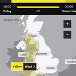
⚠️ YELLOW WEATHER WARNING FOR WIND ⚠️
Monday 3:00pm until Tuesday 3:00am
Good morning everyone,
Well, here we go again!
Just when we thought the atmosphere might give us a little breather, Mother Nature has decided Cornwall hasn't had quite enough wind and rain!
The Met Office has now issued a Yellow Weather Warning for strong winds, and we're pleased to see that once again, KWT had already highlighted the potential for disruptive weather with our own weather advisory. 👀
We've been keeping a very close eye on this developing low-pressure system, and it's always reassuring when our forecasts and concerns are reflected in the official warnings.
WHAT CAN WE EXPECT?
South to south-westerly winds will strengthen from the west during Monday afternoon and evening, with gusts reaching 45–50 mph inland and potentially 60–70+ mph along exposed coastlines and higher ground.
And unfortunately, the wind won't be arriving alone! Heavy rain at times will make travelling conditions rather unpleasant, especially on exposed roads.
⚠️ FURTHER DISRUPTION IS POSSIBLE
After the battering Cornwall has already taken from Storms Austen and Boelo, some trees, branches and structures may already be weakened.
This means we could see further fallen trees, flying debris, travel disruption and additional power cuts. Those still dealing with damage or power problems from the weekend certainly don't need another round!
The good news is that winds should gradually ease from the west during the early hours of Tuesday morning.
Here at KWT, we'll continue monitoring the latest weather charts, radar and wind observations throughout the day.
Please take extra care, secure any loose garden furniture and avoid unnecessary risks near exposed coastlines.
And if anyone knows where the switch is to turn down the Atlantic wind machine, could you please let us know? It's getting a little ridiculous now!
Stay safe, everyone.
Kind regards,
KWT Dave
Stay #WeatherAware ⚠️

Kernow Weather Team retweeted
@KWTWeather CORNWALL. 0740 UTC. EUMETSAT. Dave, don't even make the effort...

Kernow Weather Team retweeted
@KWTWeather CORNWALL. 0800 UTC. EUMETSAT. Dave, you still clinging on? Got Power? Got Coffee? Got Pasty's (or ies)?


CORNWALL RESERVOIR LEVELS ALL THIS RAIN, SO WHY ARE THEY STILL SO LOW?
Good morning everyone!
Well, it's that time again when we take a look at the water levels in two of Cornwall's major reservoirs, and unfortunately, the figures are still rather concerning!
After all the rain we've had over the last few days, including the heavy downpours brought by Storm Austen and Storm Boelo, you might be thinking our reservoirs must be filling up nicely by now!
Sadly, it's not quite that simple!
COLLIFORD RESERVOIR 31.6% FULL
Cornwall's largest reservoir is sitting at just 31.6% of its capacity, and levels have continued to fall.
STITHIANS RESERVOIR JUST 19% FULL!
Now this one is particularly concerning. Stithians is sitting at just 19% of its capacity, meaning it's less than one-fifth full!
"BUT DAVE, WE'VE HAD LOADS OF RAIN! SURELY THEY SHOULD BE FULL BY NOW?"
We get asked this quite a lot, especially after a couple of days of torrential rain!
Unfortunately, reservoirs don't work quite like filling up the bath at home. You can't just turn on the tap, wait twenty minutes and shout, "That'll do!"
When heavy rain falls onto very dry ground, some of it soaks into the soil, some runs into rivers and streams, and some eventually makes its way into our reservoirs.
But here's the important bit.
A few days of heavy rain cannot make up for months of below-average rainfall and depleted water supplies.
We need prolonged, widespread rainfall over the coming weeks and months to help restore soil moisture, river flows and reservoir storage.
And while heavy rainfall can produce a temporary increase in reservoir inflows, not every drop that falls across Cornwall ends up in Colliford or Stithians!
In fact, some of the rain we've experienced recently has simply caused surface water flooding and swollen rivers before flowing out towards the sea.
It's also worth remembering that water continues to be used every single day by homes, businesses and other customers.
So yes, the rain is welcome from a water resources point of view, but we need a sustained recovery rather than just a couple of very wet days.
AND BEFORE ANYONE ASKS...
No, KWT doesn't work for South West Water!
And no, we don't work for the government either!
We're a small independent team of weather-loving volunteers who simply share weather information, reservoir figures and other useful updates with our communities.
We're not responsible for managing the reservoirs, setting water restrictions or deciding what happens to your water bills!
If we were in charge of the weather, we'd probably arrange gentle overnight rain for the reservoirs and lovely sunshine during the day!
Although knowing Cornwall, someone would still complain about the forecast!
THE BIG PICTURE
The good news is that we're heading into the wetter part of the year, when reservoir levels would normally begin their seasonal recovery.
However, how quickly they recover will depend on rainfall over the coming months, how much water reaches each reservoir and how much is being used.
We'll continue keeping an eye on the figures and sharing updates as they become available.
And remember, heavy rain doesn't automatically mean the drought is over!
Have a lovely morning everyone, and thank you as always for your continued support.
Kind regards,
KWT Dave
From moor to shore, we've got Cornwall covered!
#KernowWeatherTeam #Cornwall #CollifordReservoir #StithiansReservoir #CornwallWeather #WaterLevels


⚠️ YELLOW WEATHER WARNING FOR HEAVY RAIN STORM BOELO ⚠️
Saturday 11:00 AM – 11:00 PM
Well, here we go again! Just when you thought Cornwall couldn't possibly get any wetter, Storm Boelo has decided we haven't had quite enough rain yet!
The Met Office have now issued a yellow weather warning for heavy rain, and we're rather pleased that once again, KWT had already highlighted the risk with our own weather advisory!
See, we're not always far wrong!
Of course, weather forecasting is never an exact science, but this is precisely why we keep such a close eye on developing weather systems and issue early advisories when we see the potential for disruption.
SO, HOW MUCH RAIN ARE WE EXPECTING?
The Met Office are forecasting widespread rainfall totals of around 25–30 mm across the warning area, with some locations, particularly higher ground, potentially receiving 50–60 mm.
And here's the important part: some places could receive a substantial amount of that rainfall in just six hours!
That's quite a lot of water falling in a relatively short period, especially considering how much rain we've already experienced over the last couple of days.
WHAT HAPPENS NEXT?
Heavy rain associated with Storm Boelo will continue affecting Cornwall through the day, bringing the risk of standing water, surface water flooding and difficult driving conditions.
During the evening, the rain may ease for a while, giving us a little breather.
But don't be fooled!
Another intense band of heavy rain is expected to move in from the west, bringing a further spell of very wet weather before the system finally clears eastwards.
Once that clears, we should see improving conditions overnight, with clearer skies developing, although a few scattered showers will remain possible.
PLEASE TAKE EXTRA CARE
With already wet roads, further heavy rainfall could quickly lead to large puddles, spray and localised flooding, particularly on low-lying roads and known flooding hotspots.
Please slow down when driving, allow extra time for journeys and never attempt to drive through floodwater.
And if your garden is starting to resemble a duck pond, I wouldn't recommend introducing actual ducks just yet!
A QUICK WORD FROM KWT
We're pleased that our earlier weather advisory highlighted the developing risk before this official warning was issued.
That's exactly what we try to do here at KWT: give you an early heads-up so you have time to prepare.
We don't issue advisories to frighten anyone. We do it because we care about keeping our communities informed and safe.
We'll continue monitoring Storm Boelo throughout the day and bring you further updates if anything changes.
Stay safe, stay dry if you can, and perhaps keep those wellies handy!
Kind regards,
KWT Dave..
Stay #WeatherAware
From moor to shore, we've got Cornwall covered!

Kernow Weather Team retweeted

Oh buoy 😕 Storm Austen giving our L4 autonomous buoy a bit of a shake up this morning!
#StormAusten #Plymouth #UK #MarineScience
More info about the buoy below 👇
