

The Louisiana Office of State Climatology strives to improve the public's understanding of climate through services, research, and education.
LSU
Joined April 2014
- Tweets2.1K
- Following1.1K
- Followers624
- Likes1.1K


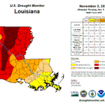


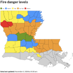
Outside of a couple of months in late spring and early summer, it's been a dry year for Louisiana. The statewide total from January-October is 40.11", which is nearly 10.00" below the 1991-2020 normal of 49.96".

34
If you think it's been warm in Louisiana this year, you're not wrong. In fact, the average temperature from January through October was 72.2 degrees, which is the 2nd warmest Jan-Oct going back to 1895. Only Jan-Oct 2023 was warmer.

44
The new US Drought Monitor depiction was released today and unfortunately it was another week of drought intensification across the state. Almost 95% of the state is in some category of drought, D4 'Exceptional' drought now covers nearly 1/5 of the state.


44
Although it hasn't happened yet, this is the time of year we would expect the first freezes of the fall in Louisiana. Across northeastern La, the first freeze is typically right about this time, further south it's mid to late November, and closer to the coast it's after Nov 30.

1
42
Ready for Thanksgiving? The Climate Prediction Center's 3-4 week outlook shows equal chances of above or below normal temperatures during the holiday but it also shows a chance of above normal precipitation. Thanksgiving might be a wet one this year!


46
LOSC retweeted
The new US Drought Monitor depiction was released today and unfortunately there was an increase in D4 'Exceptional' and D3 'Extreme' drought coverage in central and northeastern Louisiana. There were some small areas of improvement in central Louisiana and in Washington Parish.


The Shreveport National Weather Service conducted a damage survey and found that two EF0 tornadoes touched down in northwestern Louisiana on Nov 3. Thankfully, the only damage was to trees, there was no property damage or injuries reported.


88
While most of the state didn't receive a significant amount of rain over the weekend, portions of northwestern Evangeline Parish received at least 15.00" of rain per radar estimates. Also, portions of eastern Washington Parish received between 5.00"-10.00" per radar estimates.

60
A front will be passing through the state today, bringing beneficial rain and a cooldown following its passage. While the threat of isolated flooding or severe weather is small, it's not zero.

42
Despite some areas of the state receiving decent rain over the weekend, parish fire danger levels remain elevated for most of the state and most parishes still have burn bans in place.


49
LOSC retweeted

Just a locally crazy, unforeseen random event last night in Pearl River County in Mississippi. The forecast was for widely-scattered thunderstorms with a "marginal" flood risk. A tiny area got stuck beneath a downpour for HOURS, with up to 17 INCHES falling!

It has been almost completely dry across Louisiana the past three weeks, but there is hope on the horizon. A system is expected to move into the area on Halloween and provide some much-needed moisture. It won't be a drought buster, but every drop helps at this point.

41
Most of the state is mired in drought, but there may be some hope on the horizon. According to the Climate Prediction Center's outlook for November, chances are precipitation is going to be above-normal. Maybe not enough to end the drought, but it could certainly help.

1
33


The current U.S. Drought Monitor depiction showed drought expansion from the previous week, not surprisingly. Most notably, an area of D4 'Exceptional' drought was added in north-central Louisiana. That is the first time there has been any D4 in the state since late-January 2024.


1
58
Isaias is now a major hurricane with estimated max sustained winds of 120 mph. It is experiencing shear, but the shear is aligned with its motion which is limiting its negative effect. Isaias is expected to be at or near major hurricane strength at landfall in FL this evening.


1
106
Isaias now has estimated max sustained winds of 100 mph and a central pressure of 975 mb. Intensity at landfall is questionable as the system is encountering extremely warm waters AND shear. However that plays out, Isaias will still be a dangerous storm when it makes landfall.


49
Isaias continues to intensify and has estimated maximum sustained winds of 85 mph. It is currently moving ENE at 10 mph and is expected to turn north and accelerate. Peak intensity will likely be over the Gulf with some weakening occurring prior to landfall near the AL/FL border.


49
