

Short, medium & long range forecasts for southern England. No hype, no like/rt bait. Snow watch Nov➡March, weather all year round. I'm the sensible one
N London/S Herts, 130m asl
Joined May 2011
- Tweets87.1K
- Following97
- Followers12.5K
- Likes75.5K




Pinned Tweet
Hello November👋
Snow watch starts here🚦
No sign of any snow conducive air, not even a first air frost either
High pressure largely dominates first 15-20 days of Nov, with mostly average temps
Less settled conditions & somewhat cooler air may arrive late in the month
There's going to be a fair few of these showers dotted around the east today and tomorrow
Tending to fizzle out further inland
From Wednesday, this feed of north sea showers should largely stop
A convergence zone may then bring some showers to south Cornwall and Devon


The below mentioned cooler ne'ly flow arrives Sunday night into Monday
The subsequent increased breeze will likely preclude fog development during the working week

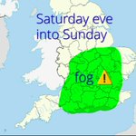
Fog is currently present across parts of the midlands and is expected to become widespread overnight, most prevalent in green shading
This will linger into Sunday in places
A weak cold front will move se during the day, bringing quite grey & dreary conditions and some drizzle

Patches of mist and fog could develop anywhere tonight
But green shading is where the most widespread dense fog is expected to form
Like today, fog should melt away to blue skies and some high cloud later in the day

Turning cooler as we move into November
From Sunday/Mon we will see max temps range around 10-12c across the south (basically average)
The same high pressure, just a cooler ne'ly flow
No air frost yet though
And for a change, there isn't a return to above average beyond that
The fog has built quite readily and widespread since around 11pm
Quite poor visibility here currently
This may lead to some tricky driving conditions in morning rush hour where fog lingers before the sunshine melts it away later in the morning ⚠️
(Fog is the greeny colour👇)

Even if you get a reversal of zonal winds which we may or may not get (technical ssw)
History tells us that when it's followed by an almost instant restrengthening of the zonal winds, the response at the surface is distinctly muted
We've been here many, many times before
I've been reading some remarkably nonsensical stuff about zonal winds
Simple truth is..
Current drop in zonal winds is aiding relaxation of the jet stream & our high pressure
But then a big rise will likely result in Atlantic lows *trying* to muscle back in late Nov/early Dec

Quite often high pressure like the one setting up brings endless cloud, even drizzle at times
But this one doesn't look too bad
From tomorrow there should be plenty of sunshine overall in most places
could be some foggy mornings though, mainly in central & western areas
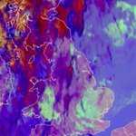
Beautiful satellite image
The warm front and accompanying rain clearing E, revealing widespread mountain/lee waves
That's those neat rows of clouds
From the ground looking up, where the lower cloud clears, you might spot some smooth, rounded lenticular clouds this afternoon
Had enough of wind & rain? You're in luck....
Strong signal for high pressure to calm things down from mid week to see out October and into early November
Lots of dry and calm weather, only a very small shower risk on occasion
Temps around average but poss chilly nights
A well defined frontal clearance always hits the spot
I'm not sure I've ever watched a cold front clear at night with stars, moon and such a straight line (the moon shot was a fail)


Those little squalls developing now
This isn't about severe weather for southern England, maybe some brief washing machine weather where the squalls pass through but nothing major
it's not until the cold front clears England that it'll be an impressive, meaty line 🤓
Mostly dry on Sunday with some sunshine & everything!
BUT
It will be windy. Especially earlier in day
For many of us, it'll be windier than Austen & Boelo - particularly inland & for Norfolk coastline⚠️
These gusts could bring down trees weakened during summer heat/drought⚠️

The back edge of the rain band (CF) might develop a squall line for parts of the south late afternoon into the evening
And into the early hours, that squall line may well stretch from SW Norway, through parts of Benelux to Western France
Here's max gusts today
still rather gusty over far east Kent, but we are now done with peak gusts from Austen
Tomorrow brings another named storm, further north in uk
A very wet one with 15-20mm quite widely across the south
Gusts 35-45mph inland & 50-60mph towards coasts


Here's max gusts so far today. Not all stations
Austen ended up a little further south & a little less deep. Hence, barely a breeze across London, E Midlands & E Anglia currently (image 2)
It'll pick up as the low pulls away, prob not up as much as 50mph in green shading tho


