

Hey everyone! I'm Meteorologist Mike Witcher. Owner/operator and Chief Meteorologist for eastTNweather. An all digital weather platform for East Tennessee.
Knoxville, TN
Joined June 2009
- Tweets22.3K
- Following415
- Followers12K
- Likes3K
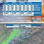





Some much-needed rain to kick off November, but the amounts depended on where you live, my friends!
The past 24-hour rainfall map shows the biggest totals along the Plateau and western areas, with around half an inch in several communities and roughly seven-tenths near Pikeville and Dunlap. Amounts tapered off farther east, with only a trace around Newport and the Tri-Cities.
Keep in mind, those map estimates can differ from the official rain gauges in the almanac. Crossville officially picked up 0.30", while Knoxville measured just 0.02" and Chattanooga 0.05".
Afternoon highs ranged from 60° in Knoxville to 67° in the Tri-Cities. And here’s an interesting detail: all four locations set their November 1 record highs back in 2016, when temperatures climbed into the 80s!
How much rain did you pick up at your house?
Let me know your total and location! 👇
@tnstandard is locally owned and operated by Kelton Balka, a fifth generation master plumber. He is a big believer in taking care of his customers which is why Tennessee Standard has thousands of five star reviews. If you’ve got an annoying plumbing issue, give him a call or book online on his website, tnstandard.com, he’d love to help you out.

Here's the rainfall outlook from today through Saturday. Swipe for the local view.
The big picture: Nashville 3", Tupelo 4", Birmingham 2", Chattanooga 2" and Knoxville 1.25". The Weather Prediction Center is painting a picture of 3 to 4 inches across parts of Middle Tennessee down into northern Alabama. For us here locally, 1 to 2 inches.
Locally: Whitwell, Dunlap, Soddy-Daisy, Dayton and Pikeville 2.5". Crossville, Rockwood, Spring City, Cleveland and Chattanooga 2". Jamestown and Athens 1.75". Knoxville, Oak Ridge and Lenoir City 1.25". Maryville and Dandridge 1". Pigeon Forge, Newport, Morristown, Greeneville, Rogersville and the Tri-Cities 0.75".
It would be nice to get one to two inches, because we desperately need it. Even though October trended about average for rainfall (we started the month with a lot of rain and then went dry), we're terribly dry right now. Make sure you check back in!
@tnstandard is locally owned and operated by Kelton Balka, a fifth generation master plumber. He is a big believer in taking care of his customers which is why Tennessee Standard has thousands of five star reviews. If you’ve got an annoying plumbing issue, give him a call or book online on his website, tnstandard.com, he’d love to help you out.


🌧️ How much rain are we talking about by Friday evening, Nov. 6? Three different models. Swipe through.
European (ECMWF): Knoxville 0.72", Chattanooga 1.7", Nashville 2.2".
GFS: Knoxville 1.3", Chattanooga 1.4", Nashville 4.8".
National Blend of Models (NBM): Knoxville 1.2", Chattanooga 1.7", Nashville 2.6".
A word of caution: don't look at the numbers too specifically. These are deterministic models and they'll change a little bit. Generally speaking, most models are showing an inch to upwards of 1 to 2 inches of rain, and the heaviest rain is going to be back to our west. We'll see how it plays out over the next couple of days. Make sure you check back in! Swipe ➡️
HERE’S WHAT EVERY HOMEOWNER NEEDS TO KNOW:
@ruralmetrofiretn
If you are an active Rural Metro Fire member, you do not pay additional fees for Rural Metro
fire suppression or emergency response covered by your membership.
If you are NOT a member and Rural Metro Fire responds to your property, you can receive a
bill for the emergency response.
In Tennessee, Rural Metro’s current published rate is a minimum of $1,800 per hour, per
firefighting vehicle. A typical structure-fire response involves a minimum of six units, which
represents an estimated minimum hourly charge of $10,800. Actual charges can vary based on
the response and services provided.
That membership isn’t just a bill. It’s your protection.


⚠️ November is our secondary severe weather season, so let's check in on the Storm Prediction Center outlooks.
Monday-Tuesday: marginal and slight risk categories out west, around Kansas City and Springfield. Tuesday-Wednesday: a marginal risk shifts toward the Mississippi River Valley, near Little Rock and Memphis.
As of right now, nothing is showing for us Wednesday-Thursday or Thursday-Friday. I don't think we're looking at severe weather locally with this system, but there will be some ramping up back to our west. This is subject to change, so check back in and we'll see what the Storm Prediction Center does. Swipe ➡️
Quick Lane Tire & Auto Center
Summer miles can add up. Get your vehicle ready for the road ahead at @rayvarnerford Quick Lane Tire & Auto Center. Schedule your service at stop by anytime


📹 This is the setup for next week's heavier rain: mid-level energy looping from Tuesday morning (Nov. 3) through Thursday at noon (Nov. 5).
Watch the big swirl in the atmosphere come through. It cranks up a southerly wind and builds high pressure out ahead of it, which warms our temperatures up. Then it splits a little, but keeps an elevated wave of energy moving through from Wednesday and Thursday into Friday.
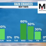
That's the deep trough that brings us the better chance of rain: 60% Wednesday, 50% Thursday and 30% Friday.
@MonsterTreeServiceofKnoxville
Without leaves, structural problems are easier to identify. Dead branches, weak or damaged limbs, cracks, and hazardous trees can become especially dangerous when exposed to strong winds, heavy rain, ice, and winter storms common to East Tennessee.
Your week ahead. Swipe through.
Rain chances: 40% today (I had 20% yesterday), 0% Monday and Tuesday, then the heavier rain arrives with 60% Wednesday, 50% Thursday and 30% Friday. Saturday is back to 0%.
The 7-day forecast: 67° Sunday, 72° Monday, 76° Tuesday, 74° Wednesday, 72° Thursday, 70° Friday and 69° Saturday. Our average high is 66°. We're back to the mid 70s by Tuesday, thanks to a southerly flow out ahead of our storm system. Behind it, the temperatures start to fall, and by Saturday we're down to a forecast high of 69° with lower dew points.
And the last swipe is the Climate Prediction Center's temperature outlook for November 7-11, which leans above average for East Tennessee. Check back in, because the numbers may change with the rain. Swipe ➡️
* MEDIC is the primary blood product provider for 24 hospitals and emergency air and ground transport services across 23 counties in East Tennessee and Southeast Kentucky.
* 1 in 7 of us will need a blood transfusion in our lifetime.
* Only 3% of eligible donors donate blood products.
•The shelf life for red blood cells is 42 days. The shelf-life for platelets is 5-7 days.
@medicblood


Planning to get up to the Smokies for some fall color? Keep the wind in mind.
Peak wind gusts today in the valley run about 14 to 17 mph: Knoxville 15, Oak Ridge and Maryville 14, Lenoir City 17. Some higher spots: Jamestown 24, Cleveland 24, Crossville 23, Newport 29 and Dunlap 30.
We have a surge of winds around 5,000 feet, and that's what cranks the wind across the highest peaks of the Smokies, so pack an extra layer if you're headed up there. The upside: with the clouds, you'll get some nice contrast with the colors in the mountains.
Swipe for your evening forecast: cloudy and 65° at 5 PM, cloudy and 60° at 7 PM, and cloudy and 57° at 9 PM. And with the time change, the sun now sets in the 5 o'clock hour, so we'll all be in our PJs by 6:30 tonight! 😄 Swipe ➡️
@MasterbatteryKnoxvilleTN
Master Battery serving Knox and surrounding communities for over 40 years. We now offer mobile installation services that allow us to come to you when battery has failed. We have what you need when you need it. Master Battery is the home of the best price, Guaranteed! So why pay more when you don’t have to.


📹 Here's your futurecast loop for the rest of Sunday, from the afternoon into the evening.
Watch how the moisture weakens and fades as this upper-level wave swings through. You can still see some heavier showers over Alabama, parts of Middle Tennessee and up into northern Georgia, but as that batch of energy comes our way it keeps weakening. That leaves us with cloudier skies and some light rain.
The heaviest rain is still expected across Middle Tennessee and parts of Alabama. Rain here at home stays on the lighter side.
@KnoxMission @KARMStores
Knox Area Rescue Ministries is a Christ-centered nonprofit dedicated to serving the homeless and vulnerable in the Knoxville area. Through shelter, meals, recovery programs, and supportive services, KARM works to restore lives with compassion, dignity, and hope.
Here's how the rain plays out today.
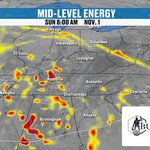
First, the mid-level energy at 8 AM. That's the upper-level wave still anchored back to our west, and it continues to track to the north and northeast.
Next, the futurecast rain totals through 9 PM tonight. The heavier rain stays west of us: Nashville 1.1", Birmingham 1.9", Montgomery 1.4", Chattanooga 0.64" and Knoxville 0.09".
Then the local view through 10 PM from the National Blend of Models. Most of us stay under a quarter inch: Knoxville 0.04", Oak Ridge 0.06", Lenoir City 0.03", Maryville 0.01". The higher totals are on the Plateau and in the southwest: Whitwell 0.28", Chattanooga 0.24", Dunlap 0.22", Crossville 0.21".
My thinking: the heaviest rain falls on the central and southern Cumberland Plateau, and we could see up to 3/4" there depending on how things play out upstream. I bumped our rain chance up to 40% today (it was 20% yesterday). Light rain, but beneficial rain.
At @burks&ogle we’ve built a reputation for delivering strong outcomes. Our attorneys combine experience, focus, and a personal approach to every case we take.
We make sure you understand your options from the start. Then we help you build a clear, proactive strategy designed to win.


So it's like the old B.J. Thomas song… raindrops are falling on my head ☔🎶 Now you'll be singing it all day!
Light, off-and-on rain today across parts of East Tennessee — a nuisance or a beneficial rain, depending on how full your glass is. Warmer Tuesday (nearly 10° above average), then a big trough brings better rain chances Wednesday–Thursday, with 1–2 inches possible. Cooler and drier by next weekend.
📲 Free East TN Weather app
📺 Also on Roku, Amazon Fire & YouTube — our 24/7 weather channel.
Mental health impacts the whole family. @mcnabbcenter offers services for children, adults and families to build healthier, stronger lives together.
Your Sunday morning check-in. Yesterday topped out at 75° and Halloween evening turned out great. This morning the clouds are keeping us nice and mild.
At 8 AM we're in the 50s: Knoxville 55°, Oak Ridge and Wartburg 56°, Jamestown 58°, Morristown and Newport 60°, Tri-Cities 52°, Crossville 52° and Soddy-Daisy 51°. Light jacket or rain jacket weather.
Your Day Planner: mostly cloudy and 63° at noon, cloudy and 67° at 3 PM, and cloudy and 65° at 5 PM.
Forecast highs land in the mid to upper 60s: Knoxville and Maryville 67°, Pigeon Forge and the Tri-Cities 68°, Newport 69°. The western valley and the Plateau stay in the low 60s: Crossville 60°, Whitwell and Dunlap 61°, Chattanooga 63°. That's a solid average day, right where we should be for this time of year.
East Tennessee Concrete Leveling the right way. The American way
@americanfwusa


Good morning, East TN, and welcome to November! We finally have rain.
This is the satellite and radar at 8 AM Sunday: a big area of showers stretching from Mississippi across Middle Tennessee and on into Kentucky, Alabama and Georgia, with the heavier batch still back to our west. Here at home we have mostly cloudy skies and some light showers that are more of a nuisance than anything else.
Drier from Tazewell to Rogersville and the Tri-Cities, with maybe a few sprinkles. As the rain from the west moves in, it should keep weakening. But because the morning showers have already saturated the atmosphere, anything that comes through later today has a better chance of reaching the ground as light rain.
Either way you look at it, this is beneficial rain. We were pushing 15 to 20 days without a single drop around town, and that streak is finally broken.
@amelsecpa is a public accounting firm that serves businesses and individuals with Tax, Accounting/Bookkeeping, and Consulting needs. Our job is to make your job easier!
Light rain is moving through as our upper level wave slides in. Since we're already seeing some light rain, it looks like the drier air has been overcome. Therefore, I'll have to watch the heavier rain in Middle Tennessee to see how that will affect us later on.
Remember to track the rain on the interactive radar with my free eastTNweather app!
Link in the comments
East Tennessee Crawl Space Encapsulation the right way. The American way.
@americanfwusa

Enjoy that “extra hour of sleep.” Your kids and dogs have declined to participate, and your microwave will finally be correct again.
Tomorrow’s schedule:
4 p.m. — Beautiful evening!
5 p.m. — Why is it midnight?
6 p.m. — Pajamas. Leftover Halloween candy. No further questions.
Turn those clocks BACK one hour tonight, my friends! I forecast weather. I cannot explain to your dog why breakfast is late.

What about after the rain? Here are the Climate Prediction Center's temperature outlooks.
November 6-10 and November 8-14 both lean above average for East Tennessee, though the second one is less warm. Remember, our average high is now 66°, and we're trending about 10° above that next week.
But keep an eye on next weekend. The models are showing a northwesterly flow behind the system, which means slightly cooler and drier air, maybe even significantly cooler. We're not talking about our first frost or freeze, but some of the model guidance is showing temperatures in the low to mid 60s. The outlook isn't painting that picture just yet, so we'll see how it all plays out. Check back with us!
@volunteerhomemortgage
You need a guide to lead you through the mortgage process so you can focus on finding the home you've been waiting for.


Three different looks at how much rain we could see by Friday evening, Nov. 6. Swipe through the models.
European (ECMWF): Knoxville 0.95", Chattanooga 2", Nashville 3.1".
GFS: Knoxville 2.4", Chattanooga 2.3", Nashville 1.9".
National Blend of Models (NBM): Knoxville 1.1", Chattanooga 1.5", Nashville 2.3".
A word of caution: don't get hung up on the exact numbers. These are deterministic models and they'll change a bit from run to run. The big picture is what matters. The Climate Prediction Center is calling for 1 to 2+ inches of rain across the region, with the bullseye likely across the Cumberland Plateau and farther west and southwest into Mississippi and Alabama. Here at home, I think a half inch to over an inch is the good bet, with an inch and a half possible.
@tnstandard is locally owned and operated by Kelton Balka, a fifth generation master plumber. He is a big believer in taking care of his customers which is why Tennessee Standard has thousands of five star reviews. If you’ve got an annoying plumbing issue, give him a call or book online on his website, tnstandard.com, he’d love to help you out.

📹 Here's what's driving next week's rain: mid-level energy (500 mb vorticity), looping from Sunday through Thursday. This shows the disturbances in the atmosphere, and watch that big, deep trough dig in.
It's likely to split based on some of the model guidance, with a little going south and a little going north. But what it will do is usher in a strong flow out of the Gulf and bring us a lot more moisture. Our humidity goes up, our precipitation chances go up, and we'll have above-average water in the atmosphere as it all comes through.
Not much rain from Sunday's wave, but then we really start to pile it up across the region Wednesday and Thursday.
HERE’S WHAT EVERY HOMEOWNER NEEDS TO KNOW:
@ruralmetrofiretn
If you are an active Rural Metro Fire member, you do not pay additional fees for Rural Metro
fire suppression or emergency response covered by your membership.
If you are NOT a member and Rural Metro Fire responds to your property, you can receive a
bill for the emergency response.
In Tennessee, Rural Metro’s current published rate is a minimum of $1,800 per hour, per
firefighting vehicle. A typical structure-fire response involves a minimum of six units, which
represents an estimated minimum hourly charge of $10,800. Actual charges can vary based on
the response and services provided.
That membership isn’t just a bill. It’s your protection.
The rain we've been waiting for finally shows up next week. Here's the week ahead.
Rain chances: 0% today, 20% Sunday, 0% Monday and Tuesday, then a jump to 60% Wednesday (up from 50% yesterday), 50% Thursday, and 20% Friday as the system wraps up.
The 7-day forecast: 75° today, 68° Sunday with light rain possible, 72° Monday, 75° Tuesday, 74° Wednesday, 72° Thursday and 70° Friday. We stay on the warmer side, about 10° above the 66° average high.
And the rainfall outlook from today through Friday has Knoxville around 1.5". My thinking for East Tennessee: a good solid half an inch to over an inch, maybe an inch and a half in the middle and latter part of the week. By then, some of us will be pushing 18 to 25 days without a drop, so we desperately need it. Swipe ➡️
Quick Lane Tire & Auto Center
Summer miles can add up. Get your vehicle ready for the road ahead at @rayvarnerford Quick Lane Tire & Auto Center. Schedule your service at stop by anytime


MAKE SURE YOU SUBCRIBE
10,000 subscribers on YouTube! Wow. Thank you, my friends!
Every time you watch a forecast, share a video, leave a comment or tell someone about eastTNweather, you help this grow. I’m so grateful you choose to spend a little of your day with me and trust me to help you plan yours.
I love talking weather, but getting to do it with this community makes it even better. Whether you’ve been here from the beginning or just found the channel, thank you for being part of it!
Here’s to more forecasts, more conversations and whatever Mother Nature throws our way!
-Mike
eastTNweather
Weather When You Want It!

🎃 Here's your OFFICIAL East TN Weather trick-or-treat forecast!
5 PM: cloudy and 74°
7 PM: cloudy and 71°
9 PM: cloudy and 64°
We stay rain-free all evening, with a little October breeze, and we cool off into the mid 60s by the end of trick-or-treating. Honestly, tonight is going to be a fantastic night, very similar to last night. Grab your costumes, charge the flashlights and have fun and stay safe out there, East TN! 👻🍬
@MonsterTreeServiceofKnoxville
Fall is the perfect time to address potential hazards before winter arrives and to plan for healthy growth when spring returns.
Don't wait until a storm creates an emergency. Let Monster Tree Service of Knoxville help you identify problems early and keep your trees safe, healthy, and beautiful throughout every season. 865-985-0881
