

Official X account for the National Weather Service Boise. Details: https://nitter.cf/t.co/kwtncnlnle
Boise, Idaho
Joined October 2012
- Tweets15.6K
- Following522
- Followers28K
- Likes6K
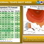
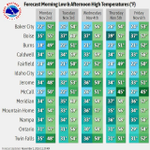




🌞A ridge of high pressure will build over the West late this week into next week. This will bring unseasonably warm temperatures, with many locations expected to approach daily record highs.

ALT A graphic showing above normal temperatures likely in the next 6-10 days for most of the US, with high temperatures in the low to mid 60s for most locations in southeast Oregon and southwest Idaho.


😶🌫️Dense fog with visibility 1/4 mile or less has developed in the Western Magic Valley this morning. Low visibility could make driving conditions hazardous. If driving, slow down, use your headlights, and leave plenty of distance ahead of you.

ALT Dense fog observed on Perrine Bridge in Twin Falls at 6:30am MST 11/1/2026.
🌧️Showers will increase this evening with isolated thunderstorms as a storm system moves into the area. Rain and high elevation snow will gradually taper off from west to east on Sunday as the system moves east.

ALT Official NWS Rainfall Forecast Today through Sunday.

ALT High end (1 in 10 chance) rainfall amounts today through Sunday.

ALT Thunderstorm Outlook today.


❄️🏔️🌧️ Valley rain and high mountain snow will return Friday, increasing in coverage late Saturday into Sunday. Snow levels will hover between 5500 to 6500 feet, with heavy accumulations on mountain summits.

ALT Valley rain and high mountain snow will return Friday, increasing in coverage late Saturday into Sunday. Snow levels will hover between 5500 to 6500 feet, with heavy accumulations on mountain summits.
Scattered showers and high mountain snow will return Tuesday. Snow levels will hover between 5000 to 6000 feet, with light accumulations from mountain showers. Temperatures will be around seasonable values.

⛈️Radar update: Showers and thunderstorms have filled in across SE Oregon and SW Idaho this afternoon. Wind gusts up to 40 mph will accompany stronger showers and storms.


Check out some rainfall totals from Wednesday Night (10/22) through Friday (10/24) across eastern Oregon and southwest Idaho. How much did you see? weather.gov/wrh/TextProduct?…

