

Official Twitter Account for the National Weather Service Northeast River Forecast Center serving New England and New York. Details: https://nitter.cf/t.co/FHkTgKM8KB
- Tweets7.4K
- Following164
- Followers9.4K
- Likes170


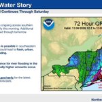

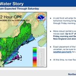


ALT The left image shows the observed precipitation over the past 72 hours. The text on the right describes the image.

ALT Image on the left depicts the rainfall measurements across the Northeast RFC region with highest amounts over eastern Connecticut, Rhode Island, and southeastern Massachusetts. Image on the right shows the latest Drought Monitor for the northeastern states, effective Nov 3

ALT The image on the right shows 72 hour rainfall totals. There is a circled area across RI and SE MA which shows there could be locally higher amounts above 2-3".

ALT Image on the right shows 72-hour precipitation forecast for the Northeast. 2-4" are expected along the southeastern coast and through coastal Maine. Southeastern Massachusetts, Rhode Island, and Connecticut are highlighted for the potential for higher amounts.

ALT Image shows 72 hour precipitation forecast for the Northeast. Widespread rain is expected, with up to 1" possible in New York, and up to 3" possible in southeastern New England and coastal Maine.

ALT The left image shows USGS streamflows status across New York and New England . The right image shows NERFC's 72-hour precipitation forecast.

ALT The image shows the 72 hour precipitation forecast for the Northeast. Up to three quarters of an inch are possible in northern Maine and up to a half an inch in western New York.

ALT Left image is Northeast 72 hour precipitation forecast, showing precipitation in northern areas with up to a half an inch in northern Maine. Right image is Northeast Drought Monitor showing continued drought conditions in multiple areas with the most severe across Maine.

ALT The image features satellite of the Northeast showing lack of cloud coverage today.

ALT The image shows Day 2 precipitation forecast for the Northeast, highlighting as dry Halloween day and night for the Northeast.

ALT The left image shows the precipitation departures from normal over the last 30 days with widespread deficits of 0-4 inches. The image on the right shows the latest drought monitor publication for New York and New England.

ALT The image shows the forecast weather map for Thursday Evening. A cold front approaching from the northwest will bring showers to western and northern New York and northern New England Thursday night and Friday.

ALT The image shows the northeast river forecast center's precipitation forecast for day 3 (8 AM Thursday to 8 AM Friday) showing widespread amounts of 0.01" to 0.10" across New York and northern New England with some isolated areas of 0.10 to 0.25" in northern New York and Vermont.

ALT The left image shows 30 day precipitation departures from normal across the NERFC region. The right image shows three day precipitation totals across the NERFC region.

ALT The image on the left shows the daily streamflows across the northeast.

ALT The image shows the Oneida River near Euclid, NY. Taken by USGS

ALT The left image shows the 72 hour forecasted precipitation.

ALT The image shows the Northeast DEWS U.S. Drought Monitor.

ALT The image shows the QPF for the next 5 days as forecasted by the Weather Prediction Center (WPC).
