

தமிழக வானிலை ஆர்வலர். Chennai based Regional Weather Tracker. Your trusted source for South India Weather Forecasts.
Tamil Nadu, Bharat
Joined January 2016
- Tweets19.1K
- Following185
- Followers14K
- Likes42.8K




Pinned Tweet
🌀 Understanding the MJO: Why it Appears "Stuck"!
The Madden-Julian Oscillation (MJO) is a naturally occurring, eastward-propagating weather system that cycles through eight distinct phases over a typical period of 30 to 60 days. It does not permanently "get stuck" in any single phase; any apparent lingering, particularly in phases 5-8, is a temporary part of its naturally irregular cycle, influenced by several complex atmospheric and oceanic factors.
⏳ Key Reasons for MJO Slowdown or Lingering: The appearance of the MJO "stuck" in phases 5, 6, 7, or 8 (the Western Pacific to Western Hemisphere) is generally due to the following reasons:
Interaction with the Maritime Continent (Phases 4 & 5):
Phases 4 and 5 occur over the Maritime Continent (Indonesia and the West Pacific). The numerous islands and mountains in this region disrupt the MJO's large-scale convection, slowing its eastward progression and making it notoriously difficult for weather models to predict accurately. Tracking its progress often relies on methods like Outgoing Longwave Radiation (OLR) measurements.
Interference from Major Climate Drivers:
The MJO's signal can be temporarily masked or slowed down by interactions with other large-scale climate patterns. A developing La Niña phase, for example, can suppress the MJO's propagation, effectively "killing the spirit" of its movement. This interference is often visible when Equatorial Rossby Waves (ERW) emerge to the west of the MJO location.
Asymmetric Ocean Warming and LaNiña:
Changes in regional sea surface temperatures, exacerbated by asymmetric ocean warming, have altered the MJO's speed. Slower propagation, particularly over the Western Pacific, can be linked to the developing or "immature" phase of a La Niña event.
Natural Variability:
The MJO's propagation is rarely smooth. Its cycle length naturally varies, sometimes extending up to 90 days. It can also become dormant for periods, contributing to the perception of it being stalled.
Model Limitations:
Current global climate models often struggle to simulate the MJO with perfect accuracy, especially over the complex geography of the Maritime Continent. This can lead to forecast runs that incorrectly show the MJO lingering in a specific phase longer than it does in reality.
🌧️ Northeast Monsoon 2025 Forecast Implications:
The MJO's current behavior holds significant implications for the Northeast Monsoon (NEM) 2025, which affects regions like Chennai.
Scenario 1: MJO Lingers (Negative Impact): If the MJO remains strong in the West Pacific (Phases 6-8) or continues to linger there until the end of November, it is likely to disrupt the monsoon flow over Southern India, potentially leading to a deficit in the Northeast Monsoon.
Scenario 2: MJO Weakens (Positive Impact): If the MJO weakens in the West Pacific or progresses quickly through its phases, it increases the likelihood of a normal NEM performance.
Note: The exact forecast track for the MJO is crucial and typically requires waiting for updates around the 10th of November for a clearer picture.


#CycloneMurasu effect, extremely heavy rainfall predicted for Guntur, Krishna, Bapatla, Palnadu and NTR districts during the next 24 hours. Be cautious!
#AndhraPradeshNews

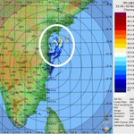
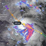
#CycloneMurasu located 200 km north northeast of Chennai. Landfall by midnight to early morning hours. The wi d speed reduced to 65 knots. Further weakening likely before landfall as it interacting with upper level dry air intrusion and land interaction! #MurasuCyclone


2 Nov 2026 - Approaching Mid to Upper Level Anticyclone speeding up Severe Cyclone Murasu movement towards Nellore, early landfall likely. Chennai and suburbs under this dry anticyclonic circulation impact!
Full story:
facebook.com/share/r/1JNM2qi…


🌀The first time a proper tamil name given to a Cyclone. That cyclone formed on Tamilnadu day. What a coincidence.
#CycloneMurasu #TamilNaduDay2026


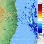
Thunderstorms appear in Chennai radar within 30 km radius. Steering wind is favourable to bring those rain bands to city and suburbs! #ChennaiRains


#murasucyclone Trajectory will decide the rainfall pattern for Chennai and Suburbs. 2nd Nov early morning to evening, the 12 hours chance for KTCC to score🌧️. South Andhrapradesh on high alert on landfall by 3rd Nov morning.
Watch my interview
youtu.be/YuW3fYjBfsI?si=mBEx…
Flash - Latest ECMWF bringing #CycloneMurasu between Chennai and Nellore. Trajectory more westward. Hope it stays.


🌀 #91B - GFS!
Just 30 hours to go, how many of you believe this forecast. Reply me!
#murasucyclone


⛈️South Karnataka in for a widespread thunderstorms from 2nd to 4th November. South Coastal and South Interior Districts has chance for thundershowers due to wind convergence and high vertical shear. Bengaluru too has chance during the same period.


🌀Bay of Bengal Watch: Depression 91B Heading Towards North/Central Andhra Pradesh
Meteorological Overview & Steering Dynamics:
facebook.com/share/r/19iLi2Z…
🤖 Made with AI

#91b Depression and MJO Influenced Westerly Trough dominated since the onset of Northeast Monsoon over South India!
The influence of east-west convergence over southeast bay of bengal, the system 91B is formed.
#bayofbengal #ChennaiRains #NorthEastMonsoon #cyclone
1/8

Post 91B we should see that scenario emerging and regular northeast monsoon will flow, probably from 2nd week of November. For rainfall activity, we need to wait and see. If at all the easterly wind and any low pressure forms post 91B, then we have good November rainfall,
7/8
Looping mjo is better than a stationery one. We need good nem in November. Let it loop, this will create circulations. Otherwise November will compensate for October excess.

#MJO is looping in phase 2 and 3 and will continue this in Nov, along with that very warm SST seen with Super #ElNiño support, so very good chance for #Chennai and overall #TamilNadu and South #AndhraPradesh to see a above normal-excess #NEM !!🌧️⛈️
#APRains #TNRains #ChennaiRains


🌀Last minute cooking, intensification of 91B the cause. This is why the system may skip Tamilnadu!
The acc over Karnataka shall support this system to remain intact and intensify. This is when ktcc districts will score ⛈️ more. The Southwest Quadrant.
#91B #BayofBengal
