







PaWeatherAlert retweeted

Easy to explain the eastern terminus of the Slight Risk in PA based on the current satellite picture.
Tough to get much surface based instability with such persistent low clouds.
PaWeatherAlert retweeted

10:35am CST #SPC Day1 Outlook Slight Risk: from parts of Texas to the Lower Mississippi Valley/Tennessee Valley and Upper Ohio Valley spc.noaa.gov/products/outloo…


PaWeatherAlert retweeted

Even though the current air temps may still be around freezing in some locations, the road temps are now all above 32°F (see map below). The remnants of the first round of rain is now north and east of Pittsburgh. The second round of rain is expected to move in by mid-afternoon.


PaWeatherAlert retweeted
Light rain showers will continue to move across north-central PA this morning, giving way to mainly dry conditions for the rest of the day with highs in the 40s and 50s. #PAwx


PaWeatherAlert retweeted
Locally heavy rainfall is possible in portions of the area late tomorrow afternoon into tomorrow night. Much of our region is in a marginal risk of excessive rainfall, with northern New Jersey in a slight risk.
Stay tuned to the latest forecasts!


PaWeatherAlert retweeted

5 pm Sat..Hurricane Larry is located 970 mi east of the Leeward Islands moving WNW at 14 mph. Larry is a category 3 hurricane with max sustained winds of 125 mph. Some additional strengthening is expected & Larry is forecast to remain a major hurricane through the early next week

PaWeatherAlert retweeted
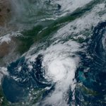
A #GOESEast view of Category 3 Hurricane Larry over the central Atlantic Saturday.


PaWeatherAlert retweeted

NWS issued a Flash Flood Warning for Berks, Chester, Delaware & Montgomery Counties until 7:00 PM Wednesday. More: weather.gov.
PaWeatherAlert retweeted

⚠️ A LARGE and RARE *HIGH* risk for excessive rainfall has been issued by our colleagues @NWSWPC The expected #rain could produce dangerous flooding in a large area of the Mid-Atlantic basin. Never drive through flooded roads! ⚠️ #TADD #PAwx #MDwx #WVwx #VAwx #DEwx #NYwx #NJwx

PaWeatherAlert retweeted

ROUTE 51 FLOODING: A portion of Route 51 is shut down due to heavy flooding and a vehicle became stuck in the waters.
LATEST UPDATES: pittsburgh.cbslocal.com/2021…
PaWeatherAlert retweeted
Also, 26 of the 32 flood deaths in PA between 2006-2018 were either outdoors or in vehicles....Pennsylvania Weather Deaths: 2006-2018


PaWeatherAlert retweeted
For a detailed overview of tomorrow's heavy rainfall, flash flood, river flood, and damaging wind/tornado threat, check out the recording of our Facebook Live briefing from earlier tonight: facebook.com/watch/live/?v=2…
#PAwx

PaWeatherAlert retweeted
5 pm Mon...Tropical Depression Ida was located 65 mi NNE of Huntsville AL moving NE at 17 mph. The remnants of Ida will bring very heavy rainfall & potentially significant flash, urban and river flooding across the upper Ohio Valley into the mid Atlantic & southern New England.


