RyanWeather.Com (@Ryan541) header
RyanWeather.Com (@Ryan541) profile picture

Southern Oregon and Northern California weather updates. My website links to weather data live from Medford, Oregon. Hourly weather updates 24/7/365.

Medford, Oregon
Joined April 2009
Photo by RyanWeather.Com (@Ryan541)Photo by RyanWeather.Com (@Ryan541)Photo by RyanWeather.Com (@Ryan541)Photo by RyanWeather.Com (@Ryan541)Photo by RyanWeather.Com (@Ryan541)Photo by RyanWeather.Com (@Ryan541)Photo by RyanWeather.Com (@Ryan541)Photo by RyanWeather.Com (@Ryan541)Photo by RyanWeather.Com (@Ryan541)Photo by RyanWeather.Com (@Ryan541)
We did see some light measurable precipitation out of the front that moved inland yesterday. Here is a look at the 24 hour observation totals across the region.
1
18
A quick glance at how we are looking so far for precipitation to begin the water year. We need a lot more to come our way. Good news is that next week looks like it will bring a solid round of rain and mountain snow to the region.
2
46
An early morning view from the Central Point webcam. Just staring to capture the early sunrise over the Rogue Valley.
5
72
With the incoming fronts next week we will see winds pick up across the region Tuesday into Wednesday of next week. Here is a look at the latest wind risk maps.
1
52
High temperatures today will trend closer to normal for this time of year. Here are the latest GFS model projections across the region.
1
45
The weak front that moved through the region yesterday is now well off to the east on satellite. We are once again seeing areas of fog and low clouds develop across the interior valleys. A few trailing showers are possible across portions of our region this morning.
3
102
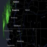
Radar returns are picking up on showers arriving along the coast. These will remain focused mostly across Curry, Coos and Douglas counties northward.
3
187
The next cold front is just offshore and will be moving inland this evening. The bulk of the precipitation looks to be focused along the coast. Even then precipitation amounts will be fairly light as it is a quick moving frontal boundary.
1
7
274
Still a lot of variability among the various forecasting models, but we are starting to get a better look at estimated precipitation amounts for next week. Most of the heaviest rainfall looks to arrive around the 10th-15th of November. These are subject to fluctuations.
3
6
64
5,701
Sunrise this morning over the Rogue Valley from the Rogue Valley Manor webcam. Clear skies are in place with cold overnight low temperatures.
2
22
529
Here is a look at where the measurable light rainfall will be focused as the next front moves inland later in the day. The bulk will be along the coast and extending into Douglas County northward.
2
12
437
It is a cold start to the morning across the region. We are seeing widespread areas of frost and freeze conditions both east and west of the Cascades.
2
9
312
Clear skies developed overnight across the region as weak high pressure rebuilds. We are seeing areas of fog and low clouds across portions of the interior valleys. Another front will approach the coast later in the day with increasing clouds across the region.
1
6
344
A beautiful morning view in Lake County from the Fish Creek Rim webcam.
14
431
A look at where measurable precipitation is most likely to develop through 5 AM Friday morning across our forecast area.
1
8
174
Radar returns this morning are showing showers moving mostly into Northern California.
1
5
147
High temperatures today will still trend a few degrees below normal. Here are the latest GFS model projections across the region.
2
4
204
Another day of clouds across the region as a front moves inland to our south and spreads showers into Northern California. This is where the highest potential for measurable rainfall is today.
1
7
205
Atmospheric River Expected to Affect the West Coast states
40
175
33
1,503
208,562
NWS Medford: “Dry conditions are expected through Monday. Rain chances return on Tuesday with a system moving into the area. Northern California and coastal areas have higher rain chances, while west side valleys and areas East of the Cascades have lower rain chances.”
10
306