




🍂 HEADED INTO PEAK FOLIAGE! 🍁
Many locations across northern and central Indiana will reach peak fall color this weekend into early next week! Across southern Indiana, this weekend could also offer some of the best viewing opportunities of the season.
If you're planning to get out and enjoy the fall colors, now may be the time! A strong storm system is expected to bring gusty winds next week, potentially knocking a significant amount of foliage off the trees and bringing the season to an end in some areas.
☀️ Tomorrow looks to be the better day for outdoor activities, with rain chances increasing later Sunday into Monday. #INwx #ILwx #OHwx #MIwx #Fall
Get out and enjoy those fall colors while they last!
#INwx #Fall #Foliage

🌬️ STRONG WINDS COULD IMPACT FALL FOLIAGE NEXT WEEK! 🍂
A strong area of low pressure is expected to bring an active start to November across the region, with widespread rain, possible thunderstorms, and some potentially gusty winds.
🍁 Looking to get out and enjoy the fall colors? This weekend may be your best opportunity!
Periods of heavy rain and gusty winds next week could knock a significant amount of foliage off the trees, bringing an end to the fall color season across portions of the region.
If you haven't gotten out to enjoy the fall scenery yet, now might be the time! 🍂 #INwx #ILwx #OHwx #MIwx #WIwx #fall

🌧️ A WET START TO NOVEMBER!
A soggy start to November is in the forecast across the Midwest! 🌧️ A strong area of low pressure and an associated cold front are expected to bring rain and thunderstorms to the region next week.
📍 Current projections suggest 1–3 inches of rainfall over the next 7 days across portions of Indiana, Illinois, Missouri, Iowa, and Kentucky, with locally higher amounts possible.
Stay tuned as we continue to monitor the timing and track of this developing storm system! 🌦️
#INwx #ILwx #OHwx #KYwx

🎃🍬 TRICK OR TREAT FORECAST: MORE TREATS THAN TRICKS! 🍬🎃
Good news, trick-or-treaters! 👻 It looks like Mother Nature is handing out more treats than tricks this Halloween Saturday across much of the region!
🌧️ A few showers could spoil the fun in parts of northern Illinois and northwestern Indiana, but most areas should stay dry with pleasant conditions for trick-or-treating!
🌡️ Evening temperatures in the 50s and 60s should make for a pretty comfortable Halloween night!
🕸️ So grab those costumes, fill up those candy bags, and get ready for some Halloween fun! 🍭
What's your costume this year? 🎃👇
#Halloween #TrickOrTreat #INwx #ILwx #OHwx #Weather

Minnesota Severe Weather Threat
A Slight Risk (Level 2/5) of severe weather has been outlined across portions of eastern Minnesota and western Wisconsin today, including the Twin Cities metro area.
Primary Threats Include:
🌬️ Damaging Winds
🌪️ Tornadoes, potentially strong
A Conditional Threat
Wind fields will be favorable for tornado development, but limited moisture could keep storm development and the overall tornado threat in check.
However, if greater moisture moves into the region than currently expected, the severe weather threat could increase. This will be a situation to monitor as conditions evolve throughout the day. #MNwx #WIwx

🌧️ Rainy Start to November!
October has brought dry conditions to much of the Midwest, allowing drought conditions to expand across portions of the region. However, November may bring some much-needed relief as a larger storm system moves across the United States!
🌧️ This system could bring beneficial rainfall to a large portion of the Midwest, with some areas potentially seeing widespread heavy rain.
📊 Through the end of next week, western portions of the region have the greatest chance of receiving 1” or more of rain, with precipitation chances and totals generally decreasing farther east.
While this rain would be a welcome change after a dry October, how much relief it brings will depend on where the heaviest rainfall ultimately develops.
#INwx #ILwx #OHwx #MIwx #WIwx #MidwestWeather #Drought

TDS Weather retweeted
NOVEMBER STARTS OFF ACTIVE?
It’s been a quiet and mild stretch of weather across the Midwest, but that could quickly change as we head into November.
Forecast data continues to suggest a strong area of low pressure developing and moving from the Rockies east/northeastward across United States from November 1–3.
While the exact track and intensity of this system will ultimately determine where the greatest impacts occur, there is the potential for widespread rain, areas of heavy rain, strong thunderstorms, and even strong non-thunderstorm winds across portions of the region.
There is still plenty of uncertainty this far out, but this is a system we’ll be watching closely as we get closer to the forecast period. November could be starting off with a much different weather pattern than what we’ve experienced recently! #INwx #ILwx #OHwx #MIwx #WIwx

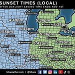
⏰ DON’T FORGET: TIME CHANGE THIS WEEKEND! 🍂
Daylight Saving Time comes to an end this weekend, meaning we’ll “fall back” one hour early Sunday morning, November 1st.
That also means earlier sunsets across the region. 🌅 As shown on our map, sunset will occur around 5:40 PM in Indianapolis, with areas farther west seeing sunset closer to 5 PM and locations farther east remaining in daylight a little longer.
The good news? We gain an extra hour of sleep!
📅 Saturday night → Sunday morning
⏰ Turn your clocks back one hour
And if you enjoy getting outside after work, it’s time to start planning around those increasingly early sunsets!
#INwx #ILwx #OHwx #KYwx #MIwx #WIwx #DaylightSavingTime #TimeChange

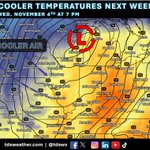
CHILLIER TEMPERATURES IN THE LONG RANGE? 🥶
While we’ll finish out October mild across the region, a larger storm system could signal a change in the weather pattern as we head into early November.
A strong area of low pressure and an associated cold front are forecast to move across the region by mid to late next week. While this system will bring rain, much colder air looks poised to surge in behind the front.
Current data suggests temperatures could return to near or even below average levels toward the end of next week. Could this be our first real taste of November chill? 👀
We’ll continue to monitor how this pattern evolves over the coming days! #INwx #ILwx #OHwx #MIwx #WIwx

NOVEMBER STARTS OFF ACTIVE?
It’s been a quiet and mild stretch of weather across the Midwest, but that could quickly change as we head into November.
Forecast data continues to suggest a strong area of low pressure developing and moving from the Rockies east/northeastward across United States from November 1–3.
While the exact track and intensity of this system will ultimately determine where the greatest impacts occur, there is the potential for widespread rain, areas of heavy rain, strong thunderstorms, and even strong non-thunderstorm winds across portions of the region.
There is still plenty of uncertainty this far out, but this is a system we’ll be watching closely as we get closer to the forecast period. November could be starting off with a much different weather pattern than what we’ve experienced recently! #INwx #ILwx #OHwx #MIwx #WIwx
WARM AGAIN THIS WEEK! ☀️
Mild weather will continue across the region this week and into the weekend, thanks to a strong upper-level ridge keeping colder air at bay.
Temperatures are expected to run 10–20° above average across much of the region this week, with another stretch of unseasonably warm weather on tap! #INwx #ILwx #OHwx #MIwx #WIwx

ANOTHER DRY WEEK AHEAD 🌤️
While the weather has been very pleasant across the region, we could certainly use some rain! Unfortunately, many of us are going to miss out on meaningful rain chances through the end of this week.
A few areas across the northern Ohio Valley and Great Lakes could see some precipitation late in the week, but rainfall amounts are expected to remain light, with little to no appreciable accumulation expected.
For much of the region, it looks like the dry pattern will continue for at least another week. 🌾💧 #INwx #ILwx #OHwx #MIwx #WIwx #AGwx


🍂 ANOTHER GREAT FALL WEEKEND AHEAD! 🍂
It’s going to be a beautiful weekend across the region, with pleasant temperatures in the 70s and plenty of sunshine! ☀️
If you’re looking to get outside and enjoy the fall colors, this weekend will be a great opportunity. Much of Indiana is seeing moderate to even high levels of fall color, with more vibrant foliage continuing to spread across the state. 🍁
Get outside, enjoy the sunshine, and take in the fall scenery while you can! #INwx #fall #foliage


There is still plenty of speculation about what the 2026–27 winter season may have in store for the Midwest and the rest of the U.S. ❄️
Here’s a look at NOAA’s Seasonal Forecast System (SFS) snowfall prediction for the December–February period. The latest outlook continues to suggest the possibility of plenty of snowfall across much of the Ohio Valley and Great Lakes region.
Of course, seasonal snowfall forecasts this far out come with plenty of uncertainty, but it’s an interesting early look at what the SFS is currently projecting for the upcoming winter. 🌨️ #INwx #ILwx #OHwx #MIwx #Snow #winter #winteriscoming

Snow and ice will be here before you know it! Keep your crews ahead of the storms this winter with reliable forecasts from tdsweather.com and access to our meteorologists 24/7. Post-storm reports by zip code available in our custom dashboard. Inquire: [email protected]
#INwx #ILwx #OHwx #MIwx #WIwx #winter #weather #snow

🌤️ Dry weather continues across the region!
For those hoping for some much-needed rainfall, the outlook over the next week isn't looking particularly promising. Dry conditions are expected to continue through the weekend and into next week.
A cold front will move through around the middle of next week, and while it could bring some areas of rain, the overall environment looks fairly dry. As a result, widespread or significant rainfall may be hard to come by.
📉 Model data over the next 7 days shows very little precipitation across much of the southern Great Lakes and Ohio Valley, with higher amounts expected farther west near the main area of low pressure.
Bottom line: Don't expect much rain over the next week. 🌤️ #INwx #ILwx #OHwx #MIwx #WIwx #AGwx #rain
