11/18 @ 11:40 | A line of heavy showers is currently moving onshore over coastal Miami-Dade County 🌧️
Current rainfall rates range from 1-3" inches ☔️
Slow moving showers can bring localized flooding, particularly for saturated, urban, and low-lying areas
#FLwx
Flooding Risk Remains
Widespread rainfall 2-4” forecast along the east coast of South Florida through Saturday morning. Localized amounts could easily reach double these estimates. If these values occur, isolated pockets of urban flooding may happen along the east coast. #flwx

ALT Flooding Risk Remains Widespread rainfall 2-4” forecast along the immediate east coast of South Florida through Saturday morning. Localized amounts could easily reach double these estimates. If these values occur, isolated pockets of urban flooding may materialize along the east coast. Precise timing and location of the heaviest rainfall remains uncertain.
Heads up Canes! Heavy rainfall will continue through Thursday evening. Please assess conditions and use caution if going outdoors.
11/18 - While a lull in rainfall across the east coast is likely this morning, periods of heavy rainfall are possible again later today.
Additional Flash flooding could occur, especially in locations that receive repeated rounds and slow moving showers/storms.
3
744
The nationwide Emergency Alert System test is now complete. See you for the next test in 3 years, per federal mandate.
We are aware of online claims that the test failed or did not happen because FEMA was hacked. Those claims are false.
FEMA will be conducting their required Emergency Alert System Test today at 2:20 PM. This test will be broadcasted via television and radio, but will NOT be sent to cell phones.
This test is done by FEMA and is not affiliated with the University or the ENN.
We’ve heard a lot of rumors about tomorrow’s EAS test. 📺📻 Let’s clear things up. It lasts 1 minute, and no action is required. No blackouts, no secret emergencies. Just our legally mandated, routine test on TV and radio at approximately 2:20 PM ET: fema.gov/press-release/20261…
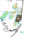
Coral Gables Campus - @NWSMiami is tracking a strong thunderstorm in our area until at least 4:15 PM. This storm is capable of producing 50-55 mph winds and funnel clouds. Assess conditions and use caution before going outside.
A special weather statement has been issued for Kendall FL, Doral FL and Cutler Bay FL until 4:15 PM EST

ALT This graphic displays a special weather statement plotted on a map. The statement is in effect until 4:15 PM EST. The statement includes Kendall FL, Doral FL and Cutler Bay FL. The threats associated with this storm are wind gusts up to 55 MPH and no hail is expected. Seek shelter in a sturdy structure until the storm passes.
1
633
Bands of heavy rain are expected to move onshore periodically through the afternoon. Storms from the Gulf are then expected to push across South Florida this afternoon through the evening.
UMiamiENN: GABLES CAMPUS – ALL CLEAR. The incident at the UC Food Court has been resolved. Normal building operations have resumed. Final update.
1
520
UMiamiENN: GABLES CAMPUS - Fire and police on scene of a small kitchen fire at UC Food Court. Buildling is being evacuated. Follow directions of police and fire at the scene. Critical updates at facebook.com/UMiamiENN
2
612
Thank you for your service, First Responders!
Today and every day, we are grateful for our partners at @umpolice, @coralgablespd, and @coralgablesfire for everything they do to keep our community safe 🧡💚 #nationalfirstrespondersday
2
560
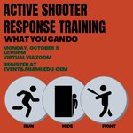
Hey Canes! Spots are still available for our virtual Active Shooter Response Training Monday, October 5, at 12 PM via Zoom. Anyone, regardless of affiliation to the University, is welcome to join. Register at events.miami.edu/oem
1
567
You know you received an ENN test, but did you know all the different ways the ENN can alert our community?
We recently activated all notification methods as once as part of our federally-required full system test. Learn more at miami.edu/ENN. #KeepingUSafe
All Campuses - @NWSMiami is tracking a strong thunderstorm in our area until at least 5:15 PM.
This storm is capable of producing 45-50 mph winds, torrential rainfall, and heavy lightning. Assess conditions and use caution before going outside.
This is a TEST Tweet posted by the University of Miami Emergency Notification Network (ENN). No action is required. Go to Facebook.com/UMiamiENN for more information about this test.
UMiami ENN Alerts retweeted
Heads up Canes! A federally-required full system test of the Emergency Notification Network will occur tomorrow (09/02) at 12:05 PM. The text message will include a link. All methods of activation will be utilized for this test. For more information visit miami.edu/ENN.
Hey Canes! Spots are still available for our virtual Active Shooter Response Training tomorrow at 12 PM via Zoom. Anyone, regardless of affiliation to the University, is welcome to join. Register at events.miami.edu/oem
542