USGS Nevada (@USGS_Nevada) header
USGS Nevada (@USGS_Nevada) profile picture

Science for a changing Nevada. Follow us for unbiased, reliable updates on USGS Nevada science.

Nevada, USA
Joined December 2011
Photo by USGS Nevada (@USGS_Nevada)Photo by USGS Nevada (@USGS_Nevada)Photo by USGS Nevada (@USGS_Nevada)Photo by USGS Nevada (@USGS_Nevada)Photo by USGS Nevada (@USGS_Nevada)Photo by USGS Nevada (@USGS_Nevada)Photo by USGS Nevada (@USGS_Nevada)Photo by USGS Nevada (@USGS_Nevada)Photo by USGS Nevada (@USGS_Nevada)Photo by USGS Nevada (@USGS_Nevada)
What can long term streamflow data tell us about Nevada's water resources? 💧 Water managers, researchers, and communities across Nevada rely on streamflow data to understand and protect our water resources. Our latest report updates streamflow statistics for 310 streamgages in Nevada and neighboring states through water year 2021 and examines long-term trends in streamflow across the region. The findings highlight the value of long-term monitoring and indicate that many Nevada streams are experiencing declining peak, average, and low flows over time. Find the report here: pubs.usgs.gov/publication/si… 📷: Martin Creek boasts having Nevada’s longest continuous streamflow record, providing invaluable data for understanding and managing the State’s water resources. Credit: Cory Rogaczewski, USGS #USGSNevadaWater #ScienceInAction
1
66
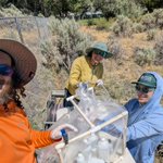
The story of the historic Comstock Lode didn't end when the mines closed. It continues to flow through the Carson River. USGS scientists are monitoring water quality in the Carson River, including sampling for mercury linked to historic milling and mining practices associated with the Comstock Lode. As Nevada celebrates Nevada Day on October 31, we're reminded that the state's history is reflected not only in its communities and landscapes, but also in its waterways. This ongoing research helps us better understand how Nevada's mining legacy continues to influence the environment today and supports informed stewardship of the Silver State's natural resources for future generations. 📷1: Carson River water quality sampling site upstream of Lahontan Reservoir near Silver Springs on 6/11/2026 📷2: The US D-95 water quality sampler being lowered in the Carson River at the sampling site below Lahontan Reservoir. Credit: Venus Cruz, USGS #NevadaDay #CarsonRiver #WaterQuality #ComstockLode
64
Meet the tinaja: the desert's hidden water source 🏜️💧 Out in the rocky landscapes of Clark County, Nevada, there are natural rock basins called tinajas (Spanish for "big jars") that fill up with rainwater and become small but vital watering holes for desert wildlife. USGS scientists spent two years (2021–2023) tracking five of these pools to answer a simple but important question: how reliable is this water source? What they found: 💧 Tinajas can hold water for weeks to months after a good rain, but they are not permanent water sources ☀️The pools ran driest between April and August, right before monsoon season kicks in 🧪 Water chemistry tests (nutrients, metals, major ions) showed levels safe for wildlife and within EPA drinking water standards This kind of baseline data helps land managers and conservationists better understand, and protect, these small but vital desert water sources that countless animals depend on. Tinajas punch way above their weight when it comes to supporting desert life! Find the report here: ow.ly/rJ0N50ZXpFw 📷1 - 4: Subset of the tinajas monitored during 2010-23 in Clark County, Nevada. Credit: Joshua Gonzales and Katie Earp, USGS
53
Surface beauty while investigating groundwater flow paths in the heart of Nevada 🌻🌄 While our field crews were out measuring and sampling wells in Hot Creek and Little Smoky Valleys, they came across striking desert blooms brightening these central Nevada basins. These valleys sit adjacent to Railroad Valley, where ongoing work helps us better understand how groundwater moves between basins—known as interbasin flow. Both groundwater levels and water chemistry can provide clues as to where the water comes from and where it is flowing. And these desert blooms were a lovely reminder of the connection between hydrology and the unique desert ecosystems that depend on Nevada’s groundwater. 💧 📷1: Blooming yellow desert flowers in Little Smoky Valley, NV. 📷2: Blooming white desert flowers in Hot Creek Valley, NV. Credit: Gwen Davies, USGS
1
59
USGS plays a vital role in water accounting in Las Vegas Valley. 💧 The USGS monitors streamflow at 10 different locations along the Las Vegas Wash, providing essential data for the region. 🌄 Accurate streamflow measurements help water resource managers in the Las Vegas Valley strengthen flood awareness and control, ensuring they have the information needed to understand how water moves through this critical urban waterway. And at two of these sites, the data also helps account for the volume and timing of water entering Lake Mead, supporting long term planning and management of Southern Nevada’s water resources. 🔗Access the 09419749 streamflow data at: ow.ly/rVmI50ZMK3z 📷: Shad Ashton pulls an Acoustic Doppler Current Profiler (ADCP) behind his kayak to measure streamflow on the Las Vegas Wash above Homestead Weir site (09419749). Photo credit: Michael Steiner
1
64
Even when the channel runs dry, the data still matter. 💦 At first glance, the PFD, hip waders, and streamgaging equipment might seem unnecessary for confirming a zero‑flow measurement. But for the USGS, accuracy and consistency come first. Zero flow isn’t “no data” — it’s a critical data point that tells us the exact condition of the river at that moment. These measurements help improve models, support water‑management decisions, and document drought and seasonal patterns. Whether it’s high flow, low flow, or no flow at all, every measurement counts. 📏 📷: Hydrologic Field Assistant, Janine Robinson, is all suited up to collect streamflow data from the dry channel of the South Fork Little Humboldt River. Photo credit: Cory Rogaczewski
60
Ever wonder how USGS keeps streamflow data accurate? 💧 📏One of the unsung heroes of our streamgages is the staff plate—the vertical ruler that shows the water level (or “gage height”). To make sure those readings stay trustworthy, we routinely run levels at our gages, which is a process using a levels rod to check elevation at designated object points around the site. Object points comprise each point that is surveyed during a levels run: reference marks (specific, permanent locations we’ve identified as references for maintaining gage datum), reference points, gages, water surface, and other points. They can be t‑posts, rebar, bolts on larger structures, or even large, stable rocks. Some of these points are installed in the most secure spots we can find and help us confirm that the staff plate hasn’t shifted over time. Others act as backup reference points—helping us obtain a reliable gage height when the staff plate is damaged or inaccessible after storms or floods. By validating both staff plates and object points, we ensure our gage heights—and ultimately our published streamflow data—are as accurate as possible. It’s careful work that keeps the nation’s water information dependable. 📷1: Hydrologic technician, Liam Mccann, verifies the staff plate is level. 📷2: A closer look at the verification process Liam is doing. 📷3: Liam uses a levels rod to check elevation at designated object points around the site. Credit: Cory Rogaczewski
2
62
In Nevada, groundwater is a lifeline—supplying at least part of the drinking water many residents rely on every day. 💧 This summer, our USGS crews were out across the Truckee Meadows and Carson City sampling deep municipal, domestic, and monitoring wells that tap the principal aquifers beneath the region. As part of the National Water Quality Program, we collect these samples every 10 years to track long‑term trends in groundwater quality. These data help communities understand changing conditions and support efforts to keep drinking water sources clean and reliable. 📷1: Sampling crew, Chris Morris, Sara Doyle, and Harold Jones, work together to collect and process a groundwater sample from a deep monitoring well in Carson City, NV. Photo credit: Chris Morris 📷2: Sampling crew, Venus Cruz and Sara Doyle, collecting a groundwater sample from a municipal well in Carson City, NV. Photo credit: Harold Jones
3
159
At the heart of one of southern Nevada’s rare wetlands, a breached dam meets cutting‑edge modeling—exposing how floodwaters might move when nature and infrastructure collide. The Ash Meadows National Wildlife Refuge is home to the Carson Slough, the largest wetland complex in southern Nevada, which provides critical habitat for several threatened and endangered species. Mud Lake Dam, a rock and earth embankment structure, stretches across the main natural channel into the Carson Slough, but was breached in the 1990s. The USGS recently developed hydrologic and hydraulic models to evaluate how modifications to the dam could affect flooding in the Carson Slough. The models simulated flood-inundation extent, depth, and velocity under a range of precipitation recurrence intervals and dam configurations. Results indicate that the evaluated dam modifications would produce only minor differences in the overall inundated area, although actual effects may vary depending on how modifications are constructed. Find the report here: pubs.usgs.gov/publication/si… 📷: Dry natural stream channel below the existing breach at Mud Lake Dam, near Ash Meadows National Wildlife Refuge, Nevada. Person for scale near the eroded embankment on the left side. Photo credit: Chris Morris
1
55
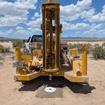
We're breaking new ground to better understand Nevada's groundwater resources. 💧 The Nevada Water Science Center recently wrapped up a successful trip to Monte Cristo and Railroad Valleys, where our team drilled new groundwater monitoring wells in some of the most data-scarce regions of the state. 🌄 These wells will provide critical long-term groundwater information to support the Nevada Water Initiative, a collaborative effort with @NevDCNR and @DRIscience. This new data will help us better understand Nevada’s water resources and strengthen science-based decision making for years to come. 📷: The augur drilling rig ready to pull away from a newly drilled monitoring well in Monte Cristo Valley, NV. Photo credit: David Smith
1
4
118
In the desert, every drop counts. 🌄💧 Springs, like Preston Big Spring, are indicators of groundwater availability, ecosystem health, and long-term hydrologic change. By keeping a close eye on springflow, we're helping land and water managers understand how groundwater resources respond to changes in, like drought and groundwater use. These summer days are long, and our field crews are taking full advantage of the extra daylight—visiting sites, checking instruments, and verifying measurements to make sure the data you rely on is accurate and on point. USGS Preston Big Spring (09415510): ow.ly/Gmay50ZqZU2 📷1: USGS equipment used to monitor springflow at Preston Big Spring. 📷2: USGS truck parked near Preston Big Spring near evening twilight. Credit: Sade Cromratie Clemons
4
85
Inspiring the next generation of water scientists 👩‍🔬 The USGS Nevada Water Science Center had the pleasure of hosting Sarayu Nithish, a curious student interested in water resources, through the Nevada Water Resources Association Student Career Shadow Program! Sarayu spent the day learning what the USGS does, how our water data and science support communities across Nevada, and why this work is so important. She also got some hands‑on field experience—complete with getting her feet wet in the Carson River—while visiting a Carson River streamgage. We’re grateful for programs like this that help inspire the next generation of water scientists, and we’re excited to see where Sarayu’s journey leads! 📷: Hydrographer Liam instructs student, Sarayu, on how to collect a streamflow measurement. Photo credit: Liam Mccann.
2
78
Safety in the field starts with the right method for the conditions. Sudden changes in stage (the height of the water surface) can make wading hazardous for our Hydrologic Technicians, and traditional tag-line methods can be difficult to perform consistently under those conditions. At the Las Vegas Wasteway, for example, flows can rise or fall quickly because the channel carries treated effluent and urban runoff. To keep technicians safely on the bank, we use a remote controlled acoustic doppler current profiler (ADCP). This lets our hydro techs collect high quality velocity and discharge measurements without entering the water. This approach helps ensure: 💧Consistent, repeatable measurements even during rapid fluctuations 💧More reliable data from sites where wading is impractical or unsafe The goal isn’t to highlight the equipment — it’s to highlight how thoughtful field methods help us keep people safe while continuing to produce dependable streamflow data at challenging locations or during challenging conditions. 🔗: USGS 09419679 (Las Vegas Wasteway): ow.ly/hNM950ZmxVY 📷: A remote controlled ADCP, sporting a fun green western-style hat, collects measurements in the Las Vegas Wasteway. Photo credit: Kristy Benson
2
93
🌄 The USGS Nevada Water Science Center recently hit the road to visit a series of remote springs across eastern Nevada. We collected water‑quality samples to better understand naturally occurring petroleum‑related compounds in these groundwater sources. Why does this matter? 💧 Because knowing what’s in your water helps everyone understand our vital water resources across the Great Basin and better equips our water and land managers to manage them. 📷1: Hydrologist Venus Cruz holds up a sample bottle full of spring water. 📷2: A spring pool with rocks of varying colors due to mineralization. Photo credit: Venus Cruz 📷3: A series of track pads, typically used to get a truck unstuck from a muddy situation, are used to create a walkable bridge to the flowing discharge pipe over boggy ground. Photo credit: Venus Cruz
10
236
There are many ways to collect water data. Sometimes it’s a single measurement taken in the moment; other times it’s continuous monitoring—often every 15 minutes—so that even rapid changes in stream, groundwater, or precipitation conditions can be accurately captured. But no matter the method, every piece of equipment we rely on is installed, maintained, and verified by USGS staff. It’s the knowledge and expertise of our scientists that ensure the data those instruments collect truly makes sense. Today, we’re excited to welcome two new Hydrologic Field Assistants, Janine Robinson and Henry Kullberg, who are already out in the field getting their feet wet—literally—as they learn the techniques and methods of streamgaging. 💧 📷: Janine and Henry practice measuring streamflow to verify the streamgage measurements. Photo credit: Scott Sylvester.
6
111
USGS scientists had a great time partnering with the Walker Basin Conservancy and many local organizations for a hands‑on field day with local 6th graders along the banks of the beautiful Walker River. Students learned about the Walker River watershed, explored how water flows through their community, and created posters showing what they believe are potential sources of pollution in their watershed. Our team also led a waterside demonstration on how scientists measure important water‑quality parameters—including pH, specific conductance, and dissolved oxygen—to understand river health. 💧🤓 It was an inspiring day of science, curiosity, and connection to Nevada’s natural resources. A huge thank‑you to all the partners and educators who made this event possible! 📷1: USGS scientists explain to students the instruments used to measure water quality field parameters. 📷2: USGS scientists discuss the Walker River watershed with students and oversee as students draw posters of river contamination.
2
50
Sometimes being passive is the only way to get the right data. 😂 Our team is deploying Polar Organic Chemical Integrative Samplers (POCIS) in a few of Nevada’s river systems to monitor pesticides moving through waterways near agricultural fields. It is difficult to monitor pesticides in surface water since water is constantly moving downstream. A single sample at a single moment may not be representative of conditions over time. These POCIS are passive samplers that quietly absorb chemicals over roughly 30 days, giving us a measure of pesticide concentrations that can be more telling than a single sample. Science doesn’t always need to make waves—sometimes it just needs to sit back, relax, and sample. ☺️ 📷1: Hydrologist Venus Cruz retrieves a deployed POCIS sampler 📷2: A POCIS sampler deployment set up with the sampler wired to a cinderblock. This ensures the POCIS stays in one place during the sampling period while keeping it off the river bottom. 📷3: A successfully deployed POCIS sampler visible beneath the river's surface. It is important the sampler remain submerged.
78
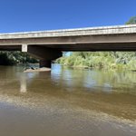
Quality matters, especially when it come to our water. 💧 We were recently collecting a water sample from Truckee River near Tracy, NV as part of a national water quality study that includes monitoring for trifluoroacetic acid (TFA). TFA is a type of PFAS chemical, sometimes called a “forever chemical,” because it doesn’t break down easily in the environment. By monitoring TFA in rivers like the Truckee, scientists can better understand where these chemicals are coming from, how they move through the environment, and what that means for water quality and ecosystem health. This work helps support informed decisions that protect both people and the environment. 📷: Hydrologist Harold Jones pours a small amount of water collected from the Truckee River using a depth-integrated sampler (the white fish-looking device hanging from the bridge crane) into a smaller vial for TFA analysis.
3
106
💧 Does groundwater pumping affect river flow? A new report describes how USGS scientists modeled the effects of groundwater pumping on the middle Humboldt River in northern Nevada. 📑 As pumping increased over the decades, more river water was drawn into the groundwater system, reducing natural river flow. In the 1960s, impacts were small, but by the late 1990s, thousands of acre feet of river water were being captured each year. If current pumping continues, river losses could grow even more. Mining operations temporarily boosted river flow in the past by discharging pumped groundwater back into the river, but once that stops, flows are expected to decline gradually over decades. New maps also highlight where pumping is most likely to affect the river, especially near the Humboldt River and its northern tributaries. Find the report here: ow.ly/6Syz50Z1TpF 📷: USGS streamgage 10322500: Humboldt River at Palisade, NV.
1
1
2
220
Does anyone else feel the wind blowing in the changing of the seasons? The strong Nevada winds seem to blow relentlessly sometimes, and these tumbleweeds rolling across the open desert near the Humboldt River by Rose Creek make for a perfect visual indicator of shifting conditions. As temperatures rise, mountain snowpack begins to melt, contributing to increased discharge in rivers and streams. Some of that meltwater infiltrates downward, recharging local aquifers and supporting early‑season groundwater availability. As we move farther into summer, however, surface flows typically recede as snowpack dwindles, evapotranspiration increases, and basin soils dry. A simple tumbleweed migration ends up telling a pretty elegant story about seasonal hydrology here in Nevada. 📹: Tumbleweeds blowing across the eastern Nevada desert. Video credit: Cory Rogaczewski
1
1
6
177