WTOC David Turley (@WtocDave) header
WTOC David Turley (@WtocDave) profile picture

Meteorologist @ WTOC

Savannah, GA
Joined January 2016
Photo by WTOC David Turley (@WtocDave)Photo by WTOC David Turley (@WtocDave)Photo by WTOC David Turley (@WtocDave)Photo by WTOC David Turley (@WtocDave)Photo by WTOC David Turley (@WtocDave)Photo by WTOC David Turley (@WtocDave)Photo by WTOC David Turley (@WtocDave)Photo by WTOC David Turley (@WtocDave)Photo by WTOC David Turley (@WtocDave)Photo by WTOC David Turley (@WtocDave)
Near record highs Friday before a return to more Fall like weather this weekend.
2
98
Drought Monitor shows we are getting dry again. Unfortunately, rain chances today and tomorrow won't help much.
1
47
Election Day looks breezy and warm with a low rain chance.
1
89
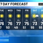
Great Fall weather for the entire First Alert 7 Day forecast.
4
218
Chilly start to our Monday! 47° was the lowest temp since the beginning of May.
2
106
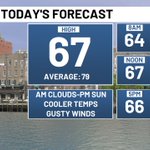
Happy Saturday! Morning clouds give way to afternoon sun. Gusty winds over 30mph bring in much cooler air.
1
1
70
Gale Warning in effect for boaters today.
2
100
Another day with near record highs but much cooler air arrives this weekend.
1
1
84
The NWS has released the data on Saturday's tornado in eastern Bulloch county. Tornado started around 2:12pm near Clito and Rough Rider Road. It stayed on the ground for about 1 mile before dissipating near Beatty Downs Drive at 2:13pm.
114
Recent rains have sure helped ease drought conditions for most of us.
60
Are you ready for a big cool down this weekend?
71
Near record highs expected the rest of the week. Cool down for the weekend.
86
Here's a look at our estimated rainfall totals since Friday morning.
1
114
Thunderstorm over coastal McIntosh county is moving quickly to the north. Locally heavy rain likely.
1
2
177
Tornado Watch has been trimmed back to include Effingham, Screven, Jasper, Beaufort and Hampton counties until 8pm.
1
3
244
We had 2 confirmed tornadoes today in Screven county. The first around 2:35pm near Halcyondale. The second was around 3:15pm just northwest of Newington.
1
125
A Tornado Watch has been issued for most counties north of the Altamaha River until 8pm.
1
1
1
140
Watching some rotation moving across northern Beaufort county. Looks like cell is moving to the NW towards Chisolm.
2
123
Flood Advisory issued for parts of Bulloch, Screven, Jenkins and Candler counties until 2:45pm.
1
1
104
Keeping our eyes on some rotation near West Green. Storm is moving NE about 55mph into Jeff Davis County.
2
1
140