

Diagnostic Radiology Resident @usask | Physician & Meteorologist
Saskatoon, SK
Joined June 2012
- Tweets8.7K
- Following590
- Followers6.8K
- Likes3.8K
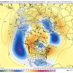
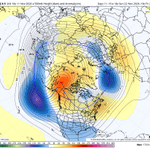







Key to the 10–15-day forecast is the ridge centred over the Beaufort Sea and Alaska. This feature is strong on the GEFS and ECMWF AI, but much weaker on the ECMWF ENS, resulting in substantial differences in the extent of Arctic air.


Hail larger than golf-ball size, as was reported in Toronto on Wednesday, is quite rare. Hail observations across Canada are relatively sparse and the historical record is limited, but seeing hail of that magnitude within the city is an unusually low-probability event.

Looking forward to speaking at AJR Live on August 11 with Dr. Scott Adams about our meta-analysis evaluating traditional machine learning, BERT models, and LLMs for CT and MRI protocolling. Thank you to @AJR_Radiology and @ARRS_Radiology for the opportunity.

I’m keeping an eye on the near-equatorial cold subsurface anomalies beginning to emerge between 120°E and the International Date Line, as they may be an early indication of what follows El Niño—potentially a sharp transition to a strong La Niña in summer 2027. @PaulRoundy1

The latest ECMWF seasonal model forecast closely resembles the patterns observed during strong El Niño analogue years.


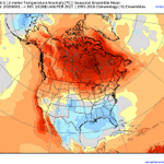
The ECMWF seasonal model is forecasting what could be the warmest winter on record across Canada, largely driven by the tropical pacific super El Niño

Tropical pacific sea surface temperature distribution for the five strongest El Nino winters since 1950
🤖 Made with AI

2
15
1,984
CanSIPS winter precipitation anomaly forecast versus the mean precipitation anomaly of the five strongest El Niño events since 1950


I think it is important to interpret the CanSIPS winter model output cautiously when it differs significantly from the leading ENSO analog years across the Great Lakes, northern Plains, and Northeast.


One unique aspect of the ongoing El Niño is its remarkable strength, with relatively few historical analogs moving into winter. Its coincidence with a westerly QBO phase further limits the sample size. Even so, strong El Niño events have generally produced exceptionally warm winters across much of Canada, often accompanied by well-below-normal snowfall at many Canadian ski resorts. My expectation is therefore that the November–March period, averaged as a whole, will finish with well above normal temperatures and generally poor snowfall conditions across much of the Canadian ski sector.
Winter snowpack and spring precipitation anomalies are important antecedent influences on Canadian wildfire seasons because they affect soil moisture and the drying of forest fuels. Several of Canada's most destructive wildfires illustrate this relationship. The 2016 Fort McMurray fire followed one of the warmest and least snowy winters on record across the Prairies, combined with persistent moisture deficits that left fuels exceptionally dry. Likewise, the 2025 La Ronge fires followed an exceptionally dry autumn, below-average winter precipitation, reduced snowpack, and limited spring rainfall, creating widespread fuel dryness before strong winds drove rapid fire growth. The 2021 Lytton fire also occurred after a dry spring and depleted soil moisture, but its explosive spread was triggered by the unprecedented Pacific Northwest heat dome, which brought record temperatures (49.6°C), extremely low humidity, and strong winds. Together, these events demonstrate how antecedent moisture deficits precondition landscapes for severe wildfire activity, while short-term extreme fire weather determines when and how rapidly fires spread.
Canada's boreal forest spans ~2.8 million km²—roughly 36% of the surface area of the continental United States, or about the size of Argentina.
Recent strong El Nino winters across Canada:
1982–83: Environment Canada described this as a “year without a winter.” Winnipeg averaged 6.6°C above normal from December through February, while snowfall from Alberta to southern Ontario was about half of normal. Arctic-air incursions were unusually scarce.
1997–98: Much of western and central Canada had a mild, relatively dry and low-snow winter, with fewer sustained Arctic outbreaks. Eastern Canada was also mild overall, but the season is remembered primarily for the catastrophic January ice storm in eastern Ontario and southern Quebec.
2015–16: This was another classic “missing winter,” with exceptional warmth across much of Canada. The Prairies were particularly mild, while the Great Lakes region experienced record December warmth, below-normal snowfall and greatly reduced lake-ice coverage.
2023–24: This became Canada’s warmest winter in the national record, averaging 5.2°C above the 1961–1990 baseline.
One possible analog for the upcoming strong El Niño winter: 1982–83, dubbed Canada’s “year without a winter.”
Western Canada was the mildest region. Vancouver’s January mean temperature reached 6.3°C, warmer than its normal March mean, while Winnipeg’s December–February average was −9.7°C (6.6°C above normal). Eastern Canada was also mild, though less exceptional.
The lack of snow was even more remarkable. Vancouver recorded no measurable snow for the first time since 1957–58, and snowfall from Alberta to southern Ontario was about half of normal. Winnipeg received 53.2 cm for the season, also roughly 50% of normal. Ski areas in Quebec and southern Ontario suffered one of their worst seasons in years.
Major winter storms were unusually scarce inland but affected both coasts. Heavy rain caused flooding and deadly mudslides near Vancouver, while central Newfoundland received about 250 mm of rain in three days, leading to major flooding and extensive damage.


