

Salt Lake City, UT
Joined August 2012
- Tweets18.4K
- Following2.6K
- Followers3.6K
- Likes31.1K




Our storm brings two waves to Utah Thursday & Friday. The first wave brings rising snow levels & mountain snow & valley rain. The second wave arrives into Friday bringing lowering snow levels & potential valley light snow.
Winter alerts up for as much as 10-20"+ N. Mtns.
#utwx


1
123
⚠ Good morning, Utah! A southerly flow is bringing warmer temps &⬆️rising snow levels today .
This is going to lead to a wet commute along the Wasatch Front, but areas above 6500' FT. will deal with some snowy conditions as moistures continues to build into the area.
#utwx


1
93
Hi there, @ChiTownNorth! A bit early for too many specifics, but the pattern looks to be very similar to the next several days. Right now, a weak system looks to be in or near Utah, but nothing that looks to significant at this time!

1
127
🌄 Our Wednesday features a nice break from the active weather across Utah. We're looking at partly sunny skies and dry conditions.
Temperatures will warm into the 30s across the mountains, 40s across the valleys, and 50s in parts of Washington county! 🆒
#utwx


1
105
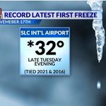
Happy Wednesday, Utah! KSLC officially hit freezing for the 1st time Tuesday evening to tie the latest fall freeze on record for SLC. 🥶Bundle up this morning, it's a cold start!
❄️We also saw our first accumulation of snow at KSLC and many of our northern valleys!
#utwx


1
1
115
⛷️ It's been a great opening day at Brian Head! The Snow stake is measuring a fresh 7" of snow from this morning. The heavier snow is now pushing into the northern mountains above 8,000' FT.
🌨️A new round of snow develops this evening with colder temps in N. UT Mtns.
#utwx


1
155
A cold front brings increasing areas of 🌧️ valley rain and 🌨️high mountain snow through our Tuesday.
🏔️Snow levels start pretty high near 8500' FT. Behind the cold front, snow levels dip down to some valley areas. A burst of snow is possible for the valleys this evening.
#utwx


3
127
Happy Tuesday, Utah! Our next storm will bring valley rain & mountain snow for our daytime hours.
- The rain could be heavy enough to produce some isolated flood concerns over parts of SW Utah.
- Winter travel conditions likely for the mtns.
#utwx


2
126
⛷️Brian Head Resort has moved the opening date up for the 2026-27 ski season to Tues. 11/17!
This weekend the resort picked up nearly 12" of fresh snow.
❄️A new Winter WX Advisory is in effect for Tuesday for an additional 6-12" of snow is possible!
Perfect ski day! 🙂
#utwx


1
178
ACTIVE WEATHER WEEK: We have two more storm systems on deck this week.
🌧️-The first arrives Tuesday bringing widespread valley rain and mountain snow chances.
🌨️- The second system may be colder and slower-moving bringing a better chance for snow/mix for the valleys.
#utwx


1
112
☔️Our next storm system arrives in the Beehive state on Tuesday bringing another round of valley rain & mtn. snow.
❄️ Snow levels will hover around 8000' FT. or higher during the day where 3-6" will be possible. 6-12" will be possible for southern Mtns above 9,000' FT.
#utwx


86
🌄Good Monday morning, Utah! It's going to be a breezy, mild day with clouds on the increase. Daytime highs will warm into the upper 50s to near 60° across the state.
☔️Our next storm system will bring more widespread valley rain & mountain snow to the state on Tuesday.
#utwx


1
120
⛷️An active pattern returns over the next 7 days bringing multiple storms into the Beehive state. Each storm will be progressively colder, bringing snow levels lower each time.
- Storm 1: Snow levels 6500'-8,000' FT (Mountains)
- Storm 2: Snow levels 5000'-6500' FT (Mtn. valleys)
- Storm 3: Snow levels 4000-4500' FT (valleys)
#utwx


1
78
Happy Friday, Utah! A southerly wind brings increasing clouds and isolated shower chances to southwest Utah.
Our next weather maker brings valley rain and mountain snow (8k FT.+) Friday evening thru Saturday.
⚠️Some travel impacts expected especially for our So. Mtns.
#utwx


2
226
Cedric Haynes retweeted

@NWSSaltLakeCity Friend from West Kaysville sent me these photos of hail that just rolled through with that supercell. #utwx

Cedric Haynes retweeted

Yesterday (July 12th) was quite historic in terms of heat across much of Utah, so here's a look at the records set across the state. In addition to numerous daily records, several all-time high temperatures were met or exceeded yesterday. #utwx

ALT The image is a chart displaying daily high temperature records set on July 12, 2026, for various locations in Utah. The chart is divided into two main columns on the left and a section on the right. Each row contains data for different locations, including the observed temperature, previous daily record, and the period of record. The temperatures are shown in degrees Fahrenheit. Locations are listed, such as Randolph, Logan, Salt Lake City, and more, alongside their respective observed temperatures and previous records. Some observed temperatures are highlighted with an asterisk to indicate they are new all-time high records.
Cedric Haynes retweeted
UPDATE: Salt Lake City has now observed a high of 109 degrees so far as of 2:58 PM MDT, which sets a new all-time temperature since records began at the site in 1874. This shatters the previous record of 107 degrees, previously set in 1960, 2002, 2021, and twice in 2022. #utwx

Cedric Haynes retweeted

Juab County Sheriff's office
#Ironfire and #Cherryfire
Eureka, Mammoth and Silver City residents can return home today at 12:00. You are on “SET” status.
Highway 6 will be open.

Cedric Haynes retweeted
#IronFire update: Highway 6 is closed at Elberta. Please avoid the area and allow residents the ability to evacuate safely.

