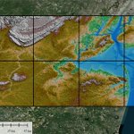
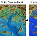
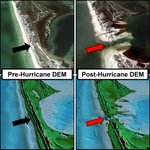
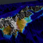
Great news to close out the year — our CUDEM paper received a Remote Sensing Best Paper Award. Excited for our advancements to the Continuously Updated Digital Elevation Model framework coming in 2026!
🙌 Remote Sensing Best Paper #Award—Second Prize (2)
"Continuously Updated Digital Elevation Models (CUDEMs) to Support Coastal Inundation Modeling”
by Christopher J. Amante et al.
🔗Available online: mdpi.com/2072-4292/15/6/1702
26
Christopher J. Amante, Ph.D. retweeted
Exciting news from #WestBoylston! 🚧Last week, DER, @MWRA_update, @MassDFG, @MassDCR & other partners celebrated a ceremonial groundbreaking for the Quinapoxet River Restoration. This #DamRemoval will restore 35 miles of river habitat, create recreational resources, & more.
🚨🚨 New Publication!
Assessing the Vertical Accuracy of Digital Elevation Models by Quality Level and Land Cover
doi.org/10.1080/2150704X.202…
It's been great collaborating with USGS colleagues as part of the NOPP Hurricane Coastal Impacts project!
nopphurricane.sofarocean.com…
28
Christopher J. Amante, Ph.D. retweeted
#mostcited
🌊Continuously Updated Digital Elevation Models (#CUDEMs) to Support #Coastal Inundation Modeling
by Christopher J. Amante, Matthew Love, Kelly Carignan, Michael G. Sutherland, Michael MacFerrin and Elliot Lim
doi.org/10.3390/rs15061702
#Marine
Great work by @IceSheetMike and the entire @NOAANCEI DEM Team!
These integrated #bathymetric and #topographic data products will help support #flood modeling and #hazard mitigation for many U.S. #coastal communities.
NCEI has released updated coastal relief models to more accurately model the movement and height of offshore waves. bit.ly/CoastalReliefModels
1
539
Christopher J. Amante, Ph.D. retweeted
Visit our new story map to learn why accurate coastal digital elevation models are vital to predicting coastal flooding. bit.ly/ETOPO_CUDEMs_StoryMap @NOAA
Christopher J. Amante, Ph.D. retweeted
Our new story map explores how continuously updated coastal DEMs help make coastal communities more resilient to high tide flooding, storm surge, and tsunamis. bit.ly/ETOPO_CUDEMs_StoryMap @NOAA
Christopher J. Amante, Ph.D. retweeted
Happy 25th birthday to GDAL ! From the first commit on 1998-10-17 from a small rural town outside of Ottawa Canada, to almost every geospatial software installation on the planet (and satellites and other planets!) in 25 years. The ultimate example of sharing & community. #foss4g
Christopher J. Amante, Ph.D. retweeted
The Clark Center for Geospatial Analytics Strategic Launch Workshop is happening
@ClarkCGA @HamedAlemo @BudhuBhaduri – at Worcester, MA
Great presentation -- Very informative overview of the wonderful capabilites of SOAR!
Thanks for the shoutout @snlussier @x4rius
What an great overview of the product vs the mission at @Soar_Earth from @snlussier Thank you! ⚡️Good also to see @umbraspace @mouthofmorrison @chrisjamante high quality maps featured 🎬 I think a 'work' trip down under is required soon guys! 🇦🇺🐨😄 youtube.com/watch?v=IoMCJVQ5…
1
1
91
Christopher J. Amante, Ph.D. retweeted
I made an app to map the floods in Vermont. There's almost 100% state coverage by satellite images from midday July 11. I added typical summer images so you can compare.
Zoom, search, turn layers on/off! Default view is major flooding in Montpelier, VT.
edethier.users.earthengine.a…
🚨🚨
New Job Posting to work at wonderful organizations!
@CIRESnews and @NOAA @NOAANCEI
CIRES/NOAA NCEI Marine Geophysical Data Manager
jobs.colorado.edu/jobs/JobDe…
#GISchat
Christopher J. Amante, Ph.D. retweeted
Splitting a raster dataset into smaller tiles with only one line of code. You can also merge all image tiles as a singe raster with only one line code.
Notebook: leafmap.org/notebooks/77_spl…
GitHub: buff.ly/3Prknqb
#geospatial #geotiff
Christopher J. Amante, Ph.D. retweeted
With this new collaboration, we can combine the best of @holy_cross’ liberal arts education with the incredible graduate training @WPI offers.
Together, we deepen our commitment to Worcester as an incredible place to live and learn. – at Worcester, MA
.@WPI and Holy Cross have joined forces to develop accelerated 4+1 dual degree programs that combine the distinctive strengths of both @TweetWorcester institutions.
🔗 bit.ly/3JAOc46
Christopher J. Amante, Ph.D. retweeted
Worcester to get first 'green' street. Here's what it means telegram.com/story/news/loca… @henrytelegram #Worcester
Christopher J. Amante, Ph.D. retweeted
In Boston, business and government work together on climate change. How about Worcester? telegram.com/story/news/loca… @henrytelegram @ajungphoto1 @holy_cross #Worcester
Christopher J. Amante, Ph.D. retweeted
#NCEI will now archive data that the Ocean Observatories Initiative, managed by the Woods Hole Oceanographic Institution (WHOI) collects from over 900 instruments! 🤯 Learn more about the goals of this collaboration: https://nitter.cf/t.co/v4UyGmu9Zw @WHOI @oceanobserv @NOAAinnovate
Christopher J. Amante, Ph.D. retweeted
A few moments from the celebration of Sarah Crump's scientific legacy today. Speakers described the joy and support she brought to all alongside her brilliant, collaborative, creative science. We're the better for her and are inspired to carry that forward.
Join us in person or on Zoom to celebrate the scientific legacy of Professor SARAH CRUMP (@sarahecrump): Wed. 10 May 2023, 10am–2pm @CUBoulder.
colorado.edu/instaar/resourc…
Sarah's colleagues & family will share words: @queenofpeat @bonesandbugs @OGG_CUBoulder @CailCon & others