

Research scholar (Ph. D.) #Agrometeorology, GBPUA&T, Pantnagar. #Worked as Meteorologist(Agril.) at ICAR-NRRI, Cuttack, Odisha #(Tweets are personal)
Cuttack
Joined August 2021
- Tweets7.2K
- Following483
- Followers1.1K
- Likes5.4K
BAY OF BENGAL | POST-LANDFALL TRACK & RAINFALL OUTLOOK, UPDATE-13
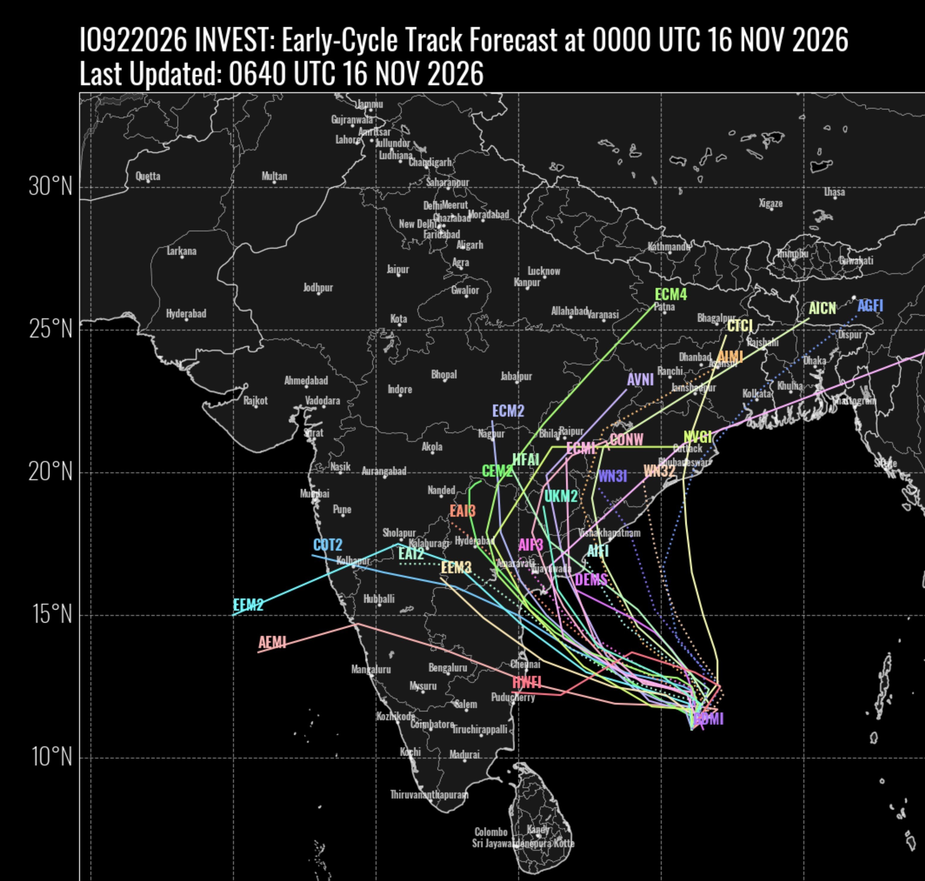
✅After landfall near the #Kakinada–#Machilipatnam belt, the anticipated cyclonic storm may initially move along the periphery of the Indo-Myanmar ridge before interacting with the Subtropical Westerly Trough

the small white circle in the image).
🌧️ Heavy rainfall potential (18–22 November): Interaction with the Subtropical Westerly Trough may enhance rainfall over:
- South and Interior Odisha
- Coastal Odisha
- Chhattisgarh
- East Telangana
- North Andhra Pradesh
✅River basins
1
1
178
✅BAY OF BENGAL | POST-LANDFALL OUTLOOK & RAINFALL WATCH, UPDATE-12
✅Most global model members continue to indicate a possible interaction between the anticipated cyclonic storm & the Subtropical Westerly Trough after landfall near the #Kakinada–#Machilipatnam belt of #Central

potential heavy rainfall, rapid runoff and rising river levels.
🌾 Farmers and local residents are advised to take precautionary measures, protect harvested paddy and ensure safe storage of agricultural produce.
Note: The post-landfall interaction, recurvature and rainfall
1
1
209
distribution remain subject to uncertainty and require continuous monitoring of updated model guidance.
#BayOfBengal #CycloneWatch #AndhraPradesh #Chhattisgarh #Odisha
1
182
✅River basins, catchments and low-lying areas across of interior Odisha particularly, the potentially affected regions should be closely monitored for the anticipated weather system and its associated rainfall activity.
✅Heavy rainfall may lead to rapid rises in river levels,

increased catchment runoff and possible flooding in vulnerable areas.
#RiverWatch #FloodRisk #AndhraPradesh #Odisha #CycloneWatch #Agromet
1
130
Majority members are dominating Sub tropical westerly trough influence which will change the systems track after landfall(From. Central Andrapradesh near Ongole-Machlipatnam) towrads East Telengana-North Andrapradesh as cyclonic storm to Chatisgarh-interior Odisha as a weak

ଓଡ଼ିଶା ଜିଲ୍ଲା ଭିତ୍ତିକ ବର୍ଷା ପୂର୍ବାନୁମାନ:
ଆସନ୍ତା 19 ତାରିଖ: ଉପକୂଳ ଜିଲ୍ଲା ଗଞ୍ଜାମ, ଗଜପତି, ପୁରୀ, ଖୋର୍ଦ୍ଧା, ଜଗତସିଂହପୁର, ବାଲେଶ୍ୱର, ଭଦ୍ରକ, କେନ୍ଦ୍ରାପଡ଼ା ଜିଲ୍ଲା ମାନଙ୍କ ରେ କିଛି କିଛି ଜାଗାରେ ହାଲୁକା ରୁ ମଧ୍ୟମ ବର୍ଷା ସହ ଗଞ୍ଜାମ, ଗଜପତି, ପୁରୀ ର ଗୋଟିଏ 2ଟି ଜାଗାରେ ଭାରି ବର୍ଷା ସମ୍ଭାବନା
✅ BAY OF BENGAL | MAJOR CYCLONE UPDATE-10
✅The system has intensified into a Deep Depression (DD) and is expected to intensify into a Cyclonic Storm today, potentially reaching Very Severe Cyclonic Storm (VSCS) intensity by 18 November, according to the latest global

1
11
1,147
ବର୍ଷା ସମ୍ଭାବନା.
ଆସନ୍ତା 21ତାରିଖ: ସମସ୍ତ ଜିଲ୍ଲା ମାନଙ୍କ ରେ ଅଧିକାଂଶ ସ୍ଥାନ ରେ ହାଲୁକା ରୁ ମଧ୍ୟମ ବର୍ଷା ସମ୍ଭାବନା.ଗଞ୍ଜାମ, ଗଜପତି, କୋରାପୁଟ, ମାଲକାନଗିରି, ରାୟଗଡା, ନବରଙ୍ଗପୁର, କଳାହାଣ୍ଡି, ନୂଆପଡା, ବଲାଙ୍ଗୀର, କନ୍ଧମାଳ, ସୋନପୁର, ଝାରସୁଗୁଡା, ବରଗଡ଼, ସୁନ୍ଦରଗଡ଼, ସମ୍ବଲପୁର ରେ କିଛି କିଛି ଜାଗାରେ ଭାରି ରୁ ଅତି
1
2
123
IMDs 11.30 AM released landfall and track forecast.


✅ BAY OF BENGAL | MAJOR CYCLONE UPDATE-10
✅The system has intensified into a Deep Depression (DD) and is expected to intensify into a Cyclonic Storm today, potentially reaching Very Severe Cyclonic Storm (VSCS) intensity by 18 November, according to the latest global
2
10
1,982
Several global models' latest 18Z late cycle runs indicate a possible interaction of the system with the Subtropical Westerly Trough after landfall over Central Andhra Pradesh.
This interaction could influence the system's post-landfall movement, intensity and subsequent

evolution.
However, considerable uncertainty remains. Let's wait for further model runs and better consensus.
#BayOfBengal #CycloneWatch #AndhraPradesh #STWJ #ModelGuidance
1
160