

Wildfire tracking ONLY on this account. CalFire NEU focus (Nevada, Yuba, Placer counties), especially Air Attack tracking.
Rough and Ready California
Joined August 2020
- Tweets1.5K
- Following114
- Followers712
- Likes150
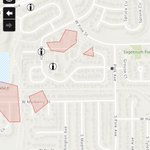




#MarshallFire for those asking about specific areas, or those tracking and new to this… go to the #FireMappers link below, it compiles info from many sources and maps the fire area. The “i” icons give info on specific reports. You can search an address, etc.

#Colorado: #MarshallFire (Superior/Louisville) - Latest fire perimeter uploaded to #FireMappers approx half an hour ago, shows the fire @ 6,000 acres & matches up w/ the info points we've heard on scanner. Link to the map is arcg.is/0y9KKr

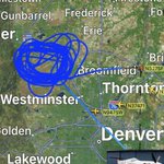
WLDLND27 leaving #marshallfire area after 2.5hrs of reconnaissance circling the fire at 22k +/- ft. keeping watch for ground crews. Will keep an eye out for refuel and return or a replacement.

Satellite heat map and wind plot of #marshallfire at 10pm MST.
NOTE: heat map shows heat NOT fire.


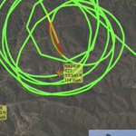
#HaleFire 9/10 4:32pm kmax was headed elsewhere but 🚁 1NE is making water drops in blue here


#InterbayFire 9/10 3:34pm 🚁 2HT continues on drops, but crews feeling good about progress, see below:


UPDATE: Crews working the #InterbayFire are confident the fire will be lined and under control by 8 pm.

#InterbayFire 9/10 2:37pm 🚁 2HT continues working Fire in these areas, hard to tell drop areas.


#LoneyFire 9/10 1:56pm SCANNER from JPR52: “completing smokejumper operations” (jumpers all deployed)

#mooneyfire 9/10 1:44pm 🚁6WL is above this fire now, looks like drops but dip may be from mobile tanks on road, not sure.

#InterbayFire 9/10 1:41pm 🚁 2HT is working the fire, making dips at Stumpy Meadows Res.

#InterbayFire 9/10 1:38pm 🚁 2HT made a few passes over fire, not sure about drops… leaving area now

#CALDORFIRE / #InterbayFire CORRECTION to my earlier tweet about Leoni Meadows… this is Loney Meadow Meadow near Bowman Lake where AirAttack is now circling. Got scanner confirmation as well #LoneyFire ? Have not seen a hash for this, they are calling it the Loney Incident


#LoneyFire 9/10 1:26pm SCANNER “JPR52 is going into jump operations”
🪂 falling soon

#LoneyFire 9/10 1:18pm Scanner: ✈️ “JMP52 you can show us coming on scene of Loney Fire” assuming they have 🪂 to deploy but did not hear them say so. This is a smokejumper plane.
