

Colorado River Historian and Provocateur
Arriola, Colorado
Joined June 2009
- Tweets8.6K
- Following2.6K
- Followers897
- Likes1.1K



Pretty good interview with Entsminger

SNWA general manager, John Entsminger, sits down with Channel 8 to discuss a wide range of water topics in Southern Nevada. 8newsnow.com/investigators/w…


The right question in #ColoradoRiver litigation? Where does the Lower Basin’s half of the III(c) Mexico obligation come from? It’s roughly 750,000 AF.
I asked Pat Mulroy, formerly @SNWA_H2O, this once. She was flummoxed and eventually stammered “All of us”. This was the right answer.
Once the LB tributaries were used up and the Gila was removed from the equation by the 1929 BCPA the LB didn’t actually have any water to cover their obligation once @CAPArizona came online and they were using and over using their 7.5 MAF. Surplus in reservoirs covered it for a while so everyone ignored the issue but that’s gone now.
LB needs an average of 9 MAF going through Lee ferry to cover the whole obligation so effectively the entire thing comes from the Upper Basin. Only with recent LB conservation are they in III(c) compliance. They can’t use more than 6.75 MAFY. All the years they weren’t they were draining the reservoirs unless there were surpluses from the Rockies.
So the irony here is LB has been in long running III(c) non compliance, now they probably aren’t, but they may sue the Upper Basin because for the first time we are… because they drained the reservoirs with their III(c) noncompliance. You can’t make this stuff up.
@azwater’s Guenther and Shiffer said exactly this in their 2007 law paper on the reasoning behind their litigation threats to get the 9 MAF in the Interim Guidelines. The ones they gamed in 2015-2019 which drained 3.75 MAF extra from Powell which is WHY THERE WASN’T ENOUGH WATER this year for a 7 MAF release putting us in III(c) non compliance by their twisted interpretation
“When only 8.23 MAF is released annually from Lake Powell, the storage in Lake Mead is depleted and Lake Mead elevation drops significantly because releases of 8.23 MAF are insufficient to satisfy the 9 MAF mainstream water allocations of the Lower Division States and Mexico, plus the associated evaporation and other losses.”
This gets to why @Interior has a “National Obligation” to remove the Mexico obligation from “all of us”.
varuna.io/LOTR/2007/guenther…


Still waiting for UCRC to give me this agreement..
“State officials said repeatedly at an Oct. 21 meeting with the Colorado River Water Conservation District that they need assurance in writing from Reclamation that the pool of stored water must be “operationally neutral” — meaning it would not be factored into reservoir releases or used by the Lower Basin — before they move forward with a state-run program.”
“Federal officials say operational neutrality for a conservation pool in Lake Powell will require approval from the Lower Basin states (California, Arizona and Nevada). At a UCRC meeting Oct. 19, the Upper Basin states approved a grant implementation agreement, which allows Reclamation to administer the contribution program grant money to the states. “
“according to a prepared statement by Wayne Pullan, Reclamation’s Upper Colorado Basin regional director, the grant agreement “does not establish any new terms for how conserved or contributed water will be credited to the system or subsequently released — that will require a separate process and agreement, as well as consensus among the seven basin states.”
aspenjournalism.org/colorado…

Mr Brightside's Powell Tracker
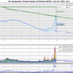
When I told you Powell was up 14' Oct 26 I was just early, it is up 14.4' since 9/15 on USBR RISE now :)
Lake Powell 3516.62' - 0.823 MAF since 2026-09-15
Lake Powell 3531.02'
14.40' Up since 9/15 low Grok confirms
The windfall to the CRSP Initial units is roughly
910,645 AF - Powell vs SEP26 24 month
356,000 AF - Navajo since low 9/16
1,266,645 AF - Total
Lower basin demanded 1 MAF, we've more than delivered, 600,000 AF of DROA from Flaming Gorge on top of that.
San Juan at Bluff is down to a respectable 5360'. Time for snow.


USBR RISE Powell data is updated to early 10/26, its quite a bit lower than the USGS instantaneous I posted yesterday.
Elevation 10/26 was 3528.66'
Powell since 9/15 is up 683,010 AF
Vs SEP26 24 month is up 772,673 AF
I told you not to trust what I posted yesterday :<
Apologies for the misinformation.
USGS also revised the San Juan Bluff gage, it has a much higher peak of 41,500 CFS vs 37,300 yesterday. It is dropping now to 24,600.
There are two reasons for discrepancy, RISE is somewhat earlier in the day and USGS has two parameters with different coordinate systems, NAVD_1988 and NGVD_1929. I have bathymetry for NAVD_1988 so was using that but it apparently reads substantially higher than USBR RISE.
Elevation for NGVD_1929:
10/26 is 3527.9'
10/27 Now is 3529.0'
Elevation for NAVD_1988:
10/26 is 3530.8
10/27 Now is 3531.9
I will have to do a bunch more research to use the instantaneous USGS gage. I definitely can't mix the two.


Ed Millard retweeted

The Four Corners region has had a generationally wet two months, with up to 27 inches of rain in the San Juan Mountains of southern Colorado.
It's been more than 40% wetter than any other late summer to fall stretch in the region since 1981, and more flooding is likely late this weekend into early next week as more tropical moisture streams in.

I love history. L Ward Bannister was a @DenverWater lawyer who toured the Lower Colorado in 1935 collecting statements on water use. These seems to put an upper bound on Imperial PPR.
Bannister had long running disagreements with Delph Carpenter over strategy around the compact:
"He and Delph E. Carpenter (the primary architect of the 1922 Colorado River Compact, often called the “Father of Interstate River Compacts”) were both key Colorado figures but frequently at odds. Historical accounts note that Bannister “often contended for leadership” with Carpenter and “frequently controverted Carpenter’s plans and policies.” Examples include differences over tactics such as suing Arizona in the Supreme Court to force action on the Compact (which Carpenter opposed, preferring to avoid litigation) and other disagreements reflected in their correspondence on apportionment, power issues, and related legislation."
varuna.io/LOTR/1935/Banniste…

Ed Millard retweeted

It has been a remarkable week of inflows at Lake Powell.
Highest ever for a month other than May or June, 44th highest ever for any 1 week period, and 18th if removing 1964 (Lake Powell's first year). 👍

“The compact has been breached, but the federal decisions are not doing anything to require that the breach be remedied, and instead are illegally placing this burden of reduced supplies, possibly on @CAPArizona’s shoulders alone,” Burman
reviewjournal.com/news/envir…

Halloween, early Nov storms are playing bumper cars. Cold NW storm is winning and keeping SW Tropical storm south & out of SW CO, we are getting snow, Central AZ is catching tropical in two waves


“lowering the price for the first tier of use, which is based on average essential indoor use in a year. The top 5% of city users with profligate outdoor watering, meanwhile, will spend a total of $98 more in all of 2027”
coloradosun.com/2026/10/28/d…

The @CAPArizona just intervened in the @SNWA_H2O APA case in Nevada District Court.
MOTION to Intervene re 1 Complaint,, by Intervenor Plaintiff Central Arizona Water Conservation District.
by Patrick Dent
storage.courtlistener.com/re…

If Navajo Reservoir hadn’t caught some of the flood it would’ve been even worse for Farmington and Shiprock. Remember that if you are or talk to people who want to remove all the dams. You can’t live on rivers without them. Adding this to lower San Juan flows would’ve been terrible:
Computed/observed inflow (item 616):
• October 22: ~22,703 cfs
• October 23: ~44,238 cfs (peak)
• October 24: ~20,992 cfs
• October 25: ~17,932 cfs
• October 26: ~10,393 cfs data.usbr.gov
Unregulated inflow (item 615): Peak of ~47,937 cfs on October 23 (with ~23,380 cfs on the 22nd).
Forecast for post Halloween storm has gotten some worse in both SW Colorado and Central AZ. Tropical storm from SW colliding with cold NW storm


USBR RISE Powell data is updated to early 10/26, its quite a bit lower than the USGS instantaneous I posted yesterday.
Elevation 10/26 was 3528.66'
Powell since 9/15 is up 683,010 AF
Vs SEP26 24 month is up 772,673 AF
I told you not to trust what I posted yesterday :<
Apologies for the misinformation.
USGS also revised the San Juan Bluff gage, it has a much higher peak of 41,500 CFS vs 37,300 yesterday. It is dropping now to 24,600.
There are two reasons for discrepancy, RISE is somewhat earlier in the day and USGS has two parameters with different coordinate systems, NAVD_1988 and NGVD_1929. I have bathymetry for NAVD_1988 so was using that but it apparently reads substantially higher than USBR RISE.
Elevation for NGVD_1929:
10/26 is 3527.9'
10/27 Now is 3529.0'
Elevation for NAVD_1988:
10/26 is 3530.8
10/27 Now is 3531.9
I will have to do a bunch more research to use the instantaneous USGS gage. I definitely can't mix the two.
Mr. Brightside's Powell Tracker:
San Juan still raging at Bluff:
37,300 CFS
Since storms started 9/15:
Powell up 809,000 AF
Relative to SEP26 Bureau Forecast:
Powell up 900,000 AF or 18 years worth of proposed 50,000 AFY Upper Basin fallowing program.
Powell about to pass Flaming Gorge's readily available storage.
Powell is using USGS instantaneous elevation so is very current.
This is new code, so don't trust it :)


Burgum cautioned that the lawsuit could backfire on a state already facing significant cuts to its Colorado River water supply. "The last thing that Arizona should want to do is have a judge decide where the water is going to go” @Interior
abc15.com/news/local-news/in…

The San Juan River swells up, spreads destruction
The latest round of storms have moved on, but flooding continues
By @Land_Desk
substack.com/app-link/post?p…
