Lin Xiong (@lin_umd) header
Lin Xiong (@lin_umd) profile picture

Currently @umdgeography, postdoc at @CoastalECU, PhD @UHEAS. Remote sensing for Earth science. Geospatial data scientist.

College Park, MD
Joined April 2018
Photo by Lin Xiong (@lin_umd)Photo by Lin Xiong (@lin_umd)Photo by Lin Xiong (@lin_umd)Photo by Lin Xiong (@lin_umd)Photo by Lin Xiong (@lin_umd)Photo by Lin Xiong (@lin_umd)Photo by Lin Xiong (@lin_umd)Photo by Lin Xiong (@lin_umd)Photo by Lin Xiong (@lin_umd)Photo by Lin Xiong (@lin_umd)
🎉🎉👇Paper Alert👇🎉🎉 sciencedirect.com/science/ar… I am super excited that my first #mangrove paper is available online! With tremendous help from co-authors! @DLagomasino, Dr. Edward Castaneda, @EarthToLola , Dr. Bruce Cook, and all others.
7
1
30
GEDI research featured at AGU fall meeting 2026 gedi.umd.edu/gedi-research-f…
1
21
GEDI - NASA's LiDAR mission, which maps the world's forests in 3D - has been extended for another 3 years. This means GEDI will operate until almost end of 2029 just before the planned retirement of the International Space Station. GEDI has been quite an incredible mission - initially launched to understand forest structure and carbon stocks, it has definitely far exceeded expectations (so the extension is not a surprise). This is yet another example of an Earth observation mission launched with scientific objectives, but then ends up having social, economic and environmental benefits, beyond the science. A couple of my favourite GEDI applications: 1. Carbon markets: Even though it has been volatile, GEDI has been the enabler for most forest carbon monitoring startups, buyers and projects, as a common global reference for forest biomass (economic impact) 2. Forest management: GEDI data combined with national forest inventories has improved estimates of forest productivity and timber volumes (economic and environmental impact) 3. Wildfire risk: GEDI data combined with Landsat has improved vegetation fuel estimation, which helps predict risk of fire (social and economic impact) 4. Conservation: GEDI has helped demonstrate how forests managed by Indigenous communities preserve biomass more effectively than other protected areas (social impact) 5. Geospatial AI: GEDI is a fundamental training data for EO foundation models like Google's AlphaEarth, which can help estimate forest height and biomass. There are probably dozens more, but I am excited for the next 3 years when GEDI datasets will be fused with other data sources, enabled by AI and leading to far more applications.
4
13
1
67
2,928
Are you going to AG6U2 @theAGU ? I will present our work on global fusion of @GEDI_Knights @NASA_ICESat2 . It is based on the hybrid inference approach that considers both measurement error and sampleing error of both missions!
1
36
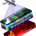
What is G-LiHT? G-LiHT is a portable, airborne imaging system that simultaneously bring LiDAR ,imaging spectroscopy, thermal measurements , G-LiHT provides fine-scale (<1 m) observations over large areas. gliht.gsfc.nasa.gov/
1
40
Lin Xiong retweeted
NEON Science Seminar next week! Join in virtually Tuesday, September 13 at 12 p.m. MDT to hear Zhongqi Miao from Microsoft, AI for Good Lab present “Project Sparrow: From the field to the lab – A full AI solution for biodiversity." Register to attend: buff.ly/AfkrqpY
1
1
1
232
This can not be one day's task without AI! I used Codex by ChatGPT to build a local website to view NASA G-LiHT data tiles. Tools used include Python + SQLite+geojson-vt + vt-pbf+MapLibre GL JS+OpenFreeMap+HTML, CSS, JavaScript+Node.js+Automated tests + browser checks.
89
EDGE NEWS Helen Fricker will join scientists, artists, writers, "curious minds from all over the world" at the Exploratorium's After Dark event: Pale Blue Dot Thu, Sep 3, 2026 • 6 - 10pm [Event Link] exploratorium.edu/visit/cale…
28
happening now !
#IGARSS2026 officially opens in Washington, D.C.! 🛰️🌎 Join us for the Opening Ceremony & Plenary Session, beginning with the official welcome and recognition of distinguished award recipients and IEEE Fellows, followed by a morning of perspectives on where Earth observation is heading next. 🎤 Prof. Indroyono Soesilo will explore Earth Observation Beyond Images: From Science to Decisions, Diplomacy, and Our Shared Future. 🌦️ Rei Goffer, Co-Founder and Chief Strategy Officer of Tomorrow.io, will look at how commercial weather satellites are changing access to environmental intelligence. 🛰️ Karen St. Germain, Director of NASA’s Earth Science Division, will take us from Earth’s core to the stratosphere through NASA’s Earth-observing missions. 🌎 Timothy Walsh of NOAA/NESDIS will close the featured talks with a look at the operational architecture behind environmental intelligence for the decades ahead. 📅 Monday, 10 August 2026 ⏰ From 08:00 AM 📍 International Ballroom Center, Washington Hilton Four perspectives. Academia, industry, NASA, and NOAA. One morning looking at the future of Earth observation. See you there! 🚀 #IEEE #GRSS #IGARSS2026 #EarthObservation #RemoteSensing #Geoscience #NASA #NOAA #WashingtonDC
56
Welcome to Washington D.C. IGARSS 2026! I will present: MO3.R18.1: "Mapping global forest canopy height through fusion of GEDI and ICESat-2 measurements" Session Time: Monday, 10 August, 13:45 - 15:00 #IGARSS2026 #GEDI #ICESat-2 #ResearchCollaboration #DataFusion
4
182
Looking forward to see the open-weight model for science. genesisopenmodels.anl.gov
36
looking forward to the talk!
Don't miss this hybrid seminar next Wed, Aug. 12! @ESALQMidias Prof Matheus Pinheiro Ferreira will talk about forest monitoring & applied remote sensing projects in Brazil. Details: geog.umd.edu/event/seminar-d…
2
3
76
Don't miss this hybrid seminar next Wed, Aug. 12! @ESALQMidias Prof Matheus Pinheiro Ferreira will talk about forest monitoring & applied remote sensing projects in Brazil. Details: geog.umd.edu/event/seminar-d…
1
2
2
236
The main driver is drought and outbreaks of bark beetles.
Europe's forests have been losing 46 % more biomass per hectare disturbed forest each year since 2018 than in any comparable period on record.🌲 A new study in @NatureGeosci is the first to measure not just where Europe's forests were disturbed, but how much biomass disappeared along with them. Severe droughts across Central Europe have triggered massive bark beetle infestations, affecting precisely the oldest and densest forests – those that contain the most biomass. This puts increasing pressure on the Europe’s forest carbon sink. Read more about the study here: climate.esa.int/en/news-even…
38