

Christ is King 👑 @WISH_TV @StormTrack8 Meteorologist. Hoosier born & raised. Devoted husband & father- Colts/Pacers fan. @BallState Alum
Indianapolis, IN
Joined December 2008
- Tweets34.9K
- Following2.7K
- Followers6.1K
- Likes12.3K


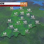
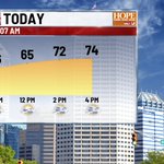

MONDAY - Gray but mild again today. Some areas of drizzle will be around pretty much all day long. Much better rain chances coming up on Wednesday.
#INwx


FRIDAY - Good morning - it's a cooler start up north this AM - but another beautiful day is on tap, as highs hit the low 70s this afternoon. Rain chances return late Saturday, with nearly daily rain chances through much of next week.
#INwx


I-465 SOUTHBOUND CLOSED on the cities east side - just north of Brookville Rd. This is due to a Semi on fire (updated 4:05am)
wishtv.com/traffic


HALLOWEEN - The thinking is we look mainly dry. Cloudy for sure as we head into trick-or-treat hours - and few sprinkles light showers can't be ruled out. Most will be dry with temps int he low 60s.
#INwx


THURSDAY - Warmest day of the week comes today - Highs in the upper 70s will push the daily record of 81° this afternoon. Halloween should be mainly dry - a few spotty sprinkles are possible in the evneing. Pattern turns wet next week with multiple rain chances.
#INwx


WEDNESDAY - A touch warmer this morning! Clouds move out and we get treated to another bright, beautiful day this afternoon with highs in the mid 70s. Rain chances are still on tap for late Saturday and Sunday.
#INwx


TUESDAY - Rinse and repeat forecast - Temps in hovering around 50° this morning. Should be a quiet start for the kids at the bus stop. Highs climb back to the mid 70s this afternoon for the 8th day in row. We're dry through Fri. rain chances ramp up late Sat./Sun
#INwx


MONDAY - Another beauty today - highs in the mid 70s for the 7th day in a row. Many more to come this week. Changes coming in Saturday/Sunday as rain a cooler temps settle in to open Nov.
#INwx


FRIDAY - Another beauty on tap today. Lunch time temps hit the mid 60s, and highs hit the lower 70s later this afternoon!
#INwx

THURSDAY - Stop me if you have heard this before. Crisp and quiet this morning - sunny and warm later this afternoon with highs in the low 70s!
#INwx


FALL COLORS - We're approaching peak colors in teh Midwest - not quite there yet. High colors are noted in northern parts of the Plains, the upper Great Lakes, and the New England states.
Map courtesy: Explorefall.com
#INwx


MONDAY - Frosty start for some this morning - and we could get a bit colder before daybreak around 8am. Temps bounce back nicely, hitting the upper 60s this afternoon.
#INwx


7:20 am #ISAIAS NOW A CAT 3 - Latest update has winds up to 120mph - likely will maintain CAT 3 status through much of the day before weakening as it approaching landfall later tonight. #Hurricane #Gulf
#INwx


8 AM EDT #ISAIAS UPDATE - #Hurricane Isaias is on the brink of becoming a major CAT 3 storm - 245 miles south of #Pensacola right now - and likely will reach CAT 3 strength by lunch time, with peak winds up to 120mph. Landfall comes late tonight along AL/FL coast
#INwx


5 AM UPDATE ON HURRICANE ISAIAS - storm has strengthen, with 110 mph winds, now a CAT 2 storm, and forecast to hit CAT 3 status this afternoon, with winds up to 120mph. Landfall still expected along AL/FL coast late Fri night. #Isaias #Hurricane
#INwx


TD 9 has now been upgraded to Tropical Storm Isaias in the Gulf, with winds up to 40mph. Track remains unchanged, making land fall late Fri/early Sat. as a high end Cat 1. hurricane -with winds near 100mph along the MS/AL/FL coast.
#INwx

