

Lead Data Scientist at TelevisaUnivision. I build machine learning/LLM models. Tropical Meteorology. Melodic House/EDM producer/DJ known as Coldfront.
Miami, FL
Joined August 2010
- Tweets13.8K
- Following277
- Followers2.4K
- Likes6.2K




Pinned Tweet
Technical paper re: Google ML hurricane forecast methodology:
storage.googleapis.com/deepm…

Google Deepmind Weather Lab has introduced a Machine Learning (ML) hurricane forecast model, which has out-performed the physics based global models in terms of track error for 2023/24. Their predictions are public and part of our guidance suite:
deepmind.google.com/science/…
PS: I am not surprised a neural net is winning - I've been building them for the last 10 years, although XGBoost still wins for my event classification models :)
2
1,814
The time on one of the images re: #Nws radars supposedly being down is something like 11:13
About 5 hours before today's incident apparently started
How are people going to detect AI imagery if they can't match up an image time and the current time of day?
#notgood

If you see reports about a nationwide NWS radar outage, IT IS FAKE NEWS.
The website used for these claims was an old out of date link, which has since been rapidly fixed and no longer displays that message. weather.gov/afc/radaroutage
1
339
The peninsula works against us with a super strong easterly flow. It and the buildings create surface convergence under an atmospheric river.
Hope that helps #noai #flwx
Heads up South Florida: Flood Watch from 10:00AM until Monday afternoon
#flwx
forecast.weather.gov/showsig…
133
Heads up South Florida: Flood Watch from 10:00AM until Monday afternoon
#flwx
forecast.weather.gov/showsig… – at Oakland Park, FL
Remarkable.
If you are not following @UWCIMSS you should be...if you are into actual meteorology stuff.... – at Oakland Park, FL

Here's a longer loop of #Isaías #Isaias in the Gulf on 10/9/2026 approaching the Florida panhandle. @NOAASatellites #GOES19 30-second color imagery from sunrise to sunset. The storm has caused significant destruction and will continue to cause problems inland.
184
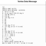
Vortex Data Message from recon in #Isaías showing a ragged eye with an elliptical shape, hopefully this is evidence the storm is starting to feel the effects of shear.
Pressure still 961mb, eyeball closed, this will be near major hurricane status at landfall, prep should be rushed to completion

Vortex Data Message from inside #Isaías suggests recon has not found flight winds above 80 knots yet
Max flight winds are displaced to the SSE by almost half of a degree. Hopefully it will continue to fight to stay vertically aligned and not intensify as much as expected, but treat this as a potential cat 2 or 3 in terms of preparation. We don't know enough to be sure whether it will rapidly intensify or not. – at Oakland Park, FL

1
273
Latest shortwave satellite imagery suggests that #TD09 in the eastern Gulf of (Take Your Pick) is getting a little better organized. Starting to get that circular shape to the overall convective envelope
3
382
Amazing satellite technology re: noreaster
5-minute @NOAASatellites #GOESEast daytime True Color RGB & Nighttime Microphysics RGB images showed the powerful Nor'easter from 1201 UTC on 25 September (off the North Carolina coast) to 2001 UTC on 27 September (after it had moved inland across New Jersey, then offshore).
Excellent work. Amazing what can be done when data are available
This quoted post is unavailable.
2
731
Michael Watkins 🇺🇦 retweeted

During the ongoing eruption of #Krakatoa in Indonesia, 10-minute @JMA_kishou Himawari-9 True Color RGB images today showed a broad lower-altitude area of volcanic ash (shades of brown) along with pulses of higher-altitude volcanic clouds (a mixture of water vapor, ash and SO2).
Michael Watkins 🇺🇦 retweeted

Incendio cerca de Krome Ave y la Okeechobee Rd. provocado por un rayo ⚡️
(Jueves 3 de septiembre)
@NWSMiami

Michael Watkins 🇺🇦 retweeted
Yesterday, September 2, 2026 (18:00-23:00UTC), 1-minute @NOAASatellites #GOESWest Visible images revealed low-altitude mesovortices within the eye of Cat5 Hurricane #Lowell in the Central Pacific. GLM Flash Points highlight the lightning activity with the surrounding eyewall.
Visible satellite imagery confirms what recon has found inside #Eduoard - it is getting better organized and is strengtheining.
Curved bands and increased deep convection are present. With only a few hours until landfall, there's still time for more strengthening - please prepare if warned.
2
642
Very recent Vortex Data Message from recon in #eduoard
Pressure down to 1002mb
Flight winds top out at 44 knots, so far, which suggests the winds have not increased significantly, yet.
Still important to prepare in case rapid strengthening occurs before landfall – at Fort Lauderdale, FL

If you are in the Hurricane Watch for #Edouard, strengthening is likely overnight. This IR satellite loop shows a well-defined curved band structure. Systems this small can intensify rapidly, please prepare for a hurricane and hope you get a rainy tropical storm
Michael Watkins 🇺🇦 retweeted

Please use extreme caution when viewing the Nepal disaster videos, besides obvious reasons. Those shared, especially by general weather/aggregator accounts are not always from this event. Scrutinize your sources and vet any reposts.
Believe it or not this is the best image I could get with my phone...of the ongoing lunar eclipse. This image looks like maybe 50%, but the actual was around 90% #eclipse – at Fort Lauderdale, FL

1
4
381
Fascinating to see the launch of a satellite in satellite imagery – at Oakland Park, FL
Congratulations to @eumetsat for what looks to be the successful launch of #MTGI2 from the Guiana Space Centre in Kourou, French Guiana. 1-minute @NOAASatellites #GOESEast true color RGB images showed the Ariane-6 rocket condensation cloud resulting from the launch.
1
1
447
Michael Watkins 🇺🇦 retweeted
Congratulations to @eumetsat for what looks to be the successful launch of #MTGI2 from the Guiana Space Centre in Kourou, French Guiana. 1-minute @NOAASatellites #GOESEast true color RGB images showed the Ariane-6 rocket condensation cloud resulting from the launch.
#Invest96l looks a little better organized tonight, looking at shortwave IR imagery.
star.nesdis.noaa.gov/GOES/se…
188