

Lexington, KY's Division of Emergency Management. This site is not monitored 24/7. In case of an emergency, dial 9-1-1. Comment policy: https://nitter.cf/t.co/qMvrX66KJw
- Tweets20.4K
- Following495
- Followers9.6K
- Likes334






ALT Weekend outlook for southern Indiana and central Kentucky, with dry conditions, highs in the 70s, and lows in the 40s.

ALT A three-day panel graphic is being displayed. With a persistent ridge overhead, nice, pleasant and warm weather will continue through the weekend. Highs will gradually warm through the weekend with low 70s to start and mid or upper 70s by Sunday afternoon.

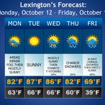
ALT A weather outlook displaying temperatures and weather icons for the rest of the week is displayed. Pleasant conditions this afternoon will continue through the rest of the week and heading into the weekend. 70s and 80s for highs with at least mostly sunny skies through then will feel great. Happy Fall!

ALT Scattered to isolated showers and storms are expected tonight and the first half of tomorrow. Warm and dry conditions will return to the forecast late weekend into early next week.


ALT Dry and pleasant weather continues for today and Wednesday. A few isolated showers/storms are possible late Wednesday night with a better chance of storms on Thursday. Dry weather returns for Friday and through the weekend.

ALT 4 day forecast graphic. Tonight: Lows in the mid 60s. Saturday: Highs in the mid to upper 80s with a 30% chance of PM storms. Sunday: Highs in the low to mid 80s and mostly sunny. Monday: Highs in the low 80s and partly cloudy. Tuesday: Highs in the low to mid 80s and partly cloudy.

ALT A graphic showing the forecast through Friday. Dry weather takes over for Tuesday with much more comfortable temperatures and humidity. Unsettled weather returns later Wednesday and Thursday.

ALT This graphic displays a flash flood warning plotted on a map. The warning is in effect until 11:45 PM EDT. The warning includes Lexington KY and Jonestown KY. This warning is for Central Fayette County in central Kentucky, North Central Jessamine County in central Kentucky and East Central Woodford County in central Kentucky. Avoid walking or driving through flood waters! Move immediately to higher ground! There are 309,968 people in the warning along with 63 schools and 9 hospitals.

ALT This graphic displays Severe Thunderstorm watch number 577 plotted on a map. The watch is in effect until 9:00 PM EDT. The watch includes parts of Illinois, Indiana and Kentucky. The threats associated with this watch are a couple tornadoes possible, isolated hail up to ping pong size possible and scattered gusts up to 75 mph likely. There are 3,000,997 people in the watch along with 881 schools and 73 hospitals.

ALT This graphic displays Severe Thunderstorm watch number 568 plotted on a map. The watch is in effect until 8:00 PM EDT. The watch includes parts of Indiana, Kentucky and Ohio. The threats associated with this watch are a couple tornadoes possible, isolated hail up to ping pong size possible and widespread gusts up to 80 mph likely. There are 2,718,576 people in the watch along with 813 schools and 62 hospitals.


ALT A graphic showing a general weather outlook for central Kentucky and southern Indiana for tonight through Monday of next week. Isolated showers and thunderstorms will be possible through sunset, with mainly dry conditions continuing for most into tonight. Scattered showers and storms will be possible Friday into Saturday, before conditions dry out again by Sunday.


ALT A graphic showing the weather outlook over the next four days for central Kentucky and southern Indiana. Patchy fog will be possible early this morning. Today will be dry and less humid than recent days, with afternoon highs in the low to mid 80s. Dry and slightly cooler weather continues through Friday. Rain and thunderstorms return to the region this weekend.


ALT This graphic displays a severe thunderstorm warning plotted on a map. The warning is in effect until 10:30 PM EDT. The warning includes Lexington KY, Nicholasville KY and Danville KY. This warning is for Mercer County in central Kentucky, Southern Woodford County in central Kentucky, Northwestern Garrard County in central Kentucky, Southern Anderson County in central Kentucky, Western Clark County in central Kentucky, Jessamine County in central Kentucky, South central Bourbon County in central Kentucky, Northeastern Washington County in central Kentucky, Northeastern Boyle County in central Kentucky, Northwestern Madison County in central Kentucky and Fayette County in central Kentucky. The threats associated with this warning are wind gusts up to 60 MPH and pea sized hail. There are 461,373 people in the warning along with 105 schools and 12 hospitals.

ALT Isolated light rain chances for the overnight, but most are expected to stay dry tonight and for the weekend. Additional isolated to scattered storms are possible Saturday. Hot and humid weather returns next week, and could see some additional storm chances develop.


ALT 4 day forecast for central KY and southern IN. Low temperatures tonight around 60. Highs Friday and Saturday in the low-mid 80s, then increasing into the upper 80s to low 90s Sunday into Monday. 30% chance storms Friday night into early Saturday, Saturday night, and again Monday night.