

🇺🇸 East Texas Native • Meteorologist • Lindale Eagle | TJC Apache | SFA Lumberjack | MSU Bulldog • FB & Instagram: Doc Deason Weather
Tyler, TX
Joined September 2009
- Tweets42.4K
- Following3.7K
- Followers4K
- Likes16.3K






THURSDAY MORNING WEATHER
(Powered By: Rose City Air & Project One Roofing & Halbert Home Services)
Good Thursday morning. For those wanting clear skies and cool air, you’re in the money and will remain entrenched for a decent spell as dry air has firmly positioned itself across East Texas.
• As a result of this, temps are again, with the exception of the high point at the Cherokee County Airport, at or below where they were at the start of the day on Wednesday.
• With the temp sitting mighty close to the dew point along with the light wind and clear sky, we also have some fog, especially across some of our southern and Deep East Texas counties. NWS has a ‘Dense Fog Advisory’ in place through mid-morning out of respect for this.
• As a general rule, anytime you’re talking fog, you’re usually talking about a pretty quiet weather pattern and that’s exactly what we’ve got, at least as far as sensible weather is concerned.
• Look for a lot of sun around the area today. This, along with a gentle southerly wind will allow temps to make their way back up into the upper 70s this afternoon. It’ll feel pretty nice, especially given the dry air at the surface.
• Additional pacific moisture will make its way back into the mix tonight and we will deal with a string of days containing more clouds than not through the upcoming weekend.
• As I’ve been mentioning, the added clouds along with the passage tonight of a reinforcing front will help to keep us on the cooler side of the ledger, too.
• By Sunday night, a weak system aloft could have enough moisture with it to produce a stray shower or two, but those chances are still mighty slim. And while we should clear behind that system, temps don’t look quite as cool to start next week as they did 24 hours ago. Still, it’ll be cool on Monday morning and each of the mornings through the middle of next week. I wish I could say I see some good rainfall potential between now and then, but I don’t at this time.
• Tropical Update: NHC continues to watch a system south of Bermuda which has some decent potential to take on some subtropical characteristics as it moves out farther into the Atlantic, at least for a time, while not posing a risk to the US Mainland. Otherwise, there continues to be nothing on the board as far as other activity is concerned.
☀️ Today • Sunrise: 6:41 am - Sunset: 5:27 pm | Total Daylight: 10:45 (-1:39) ⎥ Tyler Normals: 50/71 – Records: 85°/1987 -- 25°/1976 – 2.11”/2024
📊 Lower 48 Temp Extremes for Wednesday: 91° at 8 miles west of Miles City, Florida & at 7 miles east-southeast of Hidalgo🔹11° at 32 miles west-southwest of Bynum, Montana
• Wednesday Climate Stats • Tyler City: 52/77 (0) -- Tyler Pounds: 53/77 (0) -- Longview: 52/76 (0) – Lufkin: 52/76 (0) #etxwx #txwx

Deace, bringin’ the Rocky swagger, @xmikemac.

Republicans MUST learn that their credibility as a party is broken after last night's elections, @SteveDeaceShow tells me. And if they want to regain trust, he believes President Trump has to lead the charge:
“He’s got to get the Eye of the Tiger back… The guy with the biggest microphone to re-establish [credibility] is the president… and he’s done this before. I mean, you’re talking about a guy who literally got shot in the face and had to re-evaluate some things. You’re talking about a guy who’s been bankrupt four times, who’s been excommunicated from Hollywood multiple times.
Maybe the greatest description of Donald Trump I’ve ever heard is: Donald Trump succeeds by sheer guile. That he refuses to quit in the face of things that would make other men lay down.”
WEDNESDAY MORNING WEATHER
(Powered By: Rose City Air & Project One Roofing & Halbert Home Services)
Good morning and welcome to Wednesday. Much cooler and drier air has worked its way into the region over the last 24 hours and you’re seeing the result of that around the area this morning in the form of temps that area anywhere from 15-24° cooler this morning then they were at the start of the day on Tuesday.
• Thankfully, even though the rain is now long since gone, we did manage some very beneficial totals on Tuesday across some previously rain-deprived areas of East Texas. Widespread >2” totals across Rusk and Panola Counties were the most noteworthy.
• From here, we dry for a while, once again. Unlike October, which is toward the top of the chart insofar as monthly rain totals are concerned, November falls much further down that list at all three of our climate sites, which is not the most encouraging news given the disappointment of last month.
• Mild and quiet will best describe the weather across our neck of the woods over the next few days as a dry airmass maintains a pretty firm grip.
• We will reinforce the airmass late Thursday night/early Friday with another front, and that will really help to push us down that cooler road through the weekend as clouds will begin to mix back into the sky this weekend, too. Between the cooler airmass and a lack of full sun, it’ll feel kinda cool this weekend generally speaking. A slim rain chance should cross the area on Saturday night, too, albeit with even lower potential for much in the way of totals.
• As I mentioned yesterday, we still look set for our coolest temps of the season by early next week, with many folks realizing 30s for the first time since last Spring on Monday morning.
• The longer range continues to look dry as we move through the latter part of next week, with that overall trend likely to continue as we move through the following weekend and into the start of what would be the week before Thanksgiving.
• Tropical Update: NHC continues to watch for the development of a system south of Bermuda over the next couple of days and it has some decent potential to further develop as it moves out farther into the Atlantic, at least for a time, while not posing a risk to the US Mainland. Otherwise, there continues to be nothing on the board as far as other activity is concerned.
☀️ Today • Sunrise: 7:41 am - Sunset: 5:28 pm | Total Daylight: 10:47 (-1:40) ⎥ Tyler Normals: 50/72 – Records: 86°/2024 -- 24°/1991 – 2.00”/1925
📊 Lower 48 Temp Extremes for Tuesday: 92° at 3 miles southeast of Linn🔹11° at 32 miles west-southwest of Bynum, Montana & at 37 miles east-southeast of Wahsatch, Utah
• Tuesday Climate Stats • Tyler City: 60/75 (0.76”) -- Tyler Pounds: 59/75 (1.31”) -- Longview: 57/75 (MM) – Lufkin: 57/81 (0.43”) #etxwx #txwx

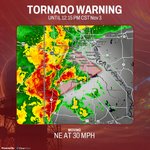
Tornado Warning in effect until 12:15 PM CST for Caddo, De Soto, and Panola Counties, with a radar-confirmed tornado near Shreveport, Stonewall, and Keithville moving northeast at 30 mph, so please shelter in an interior room now.


Tornado Warning update for Shreveport in Caddo County. A severe thunderstorm with radar-indicated rotation is 6 miles southwest of Shreveport, moving northeast at 30 mph. Get to an interior room on the lowest floor of a sturdy building now.

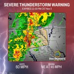
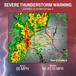
Severe Thunderstorm Warning until noon for Shreveport, Bossier City, Carthage, Greenwood, Blanchard, and Waskom with 60 mph wind gusts and hail moving northeast at 45 mph, so get inside a sturdy building and stay away from windows now.


Tornado Warning update for Caddo and De Soto Counties. A storm near Stonewall is moving northeast at 30 mph toward Shreveport, Keithville, and Spring Ridge. Take cover now in an interior room on the lowest floor and stay away from windows.

A confirmed tornado is on the ground 8 miles west of Stonewall, heading northeast at 30 mph toward Shreveport, Keithville, and Spring Ridge. Get to an interior room on the lowest floor now and stay away from windows.

Severe Thunderstorm Warning updated for Shreveport, Bossier City, Stonewall, and nearby areas with 60 mph wind gusts and small hail possible, so please head indoors now and stay away from windows until storms pass.

TUESDAY MORNING WEATHER
(Powered By: Rose City Air & Project One Roofing & Halbert Home Services)
Good Tuesday morning and welcome to Election Day – 2026! Some of you were awakened by some thunder earlier this morning. We had some of that at my place around 5:00 or so, but outside of some brief rain, that was the extent of the excitement.
• Besides the showers and thunderstorms that we have around our area, there’s a pretty decent temperature gradient across North Texas this morning, thanks to the approaching cold front, with 70s across East Texas and 50s across the northwestern parts of the Metroplex further behind the front.
• We’ll see showers and thunderstorms gradually work their way across the area from west to east this morning before the drying trend also moves in from the west. This will eventually be followed by a clearing of the sky too…helped along by the much drier air that’ll work its way in as the day progresses.
• Overall severe weather risk continues pretty low for today across our area, with the timing of things for our central counties and how it relates to more stable hours of the day due to a lack of daytime heating for such a long time. That said, as we move deeper into the morning and begin to try and recharge things, some resurgence in storms can’t be completely ruled out across the eastern counties later this morning, with wind being the primary concern. SPC will also maintain a low tornado potential as well.
• By tonight, we should be pretty well cleared of the clouds, and this will set us up for a cooler night area-wide as the wind subsides as well.
• Generally speaking, we’ve got ourselves a pretty quiet rest of the 7-day cycle overall as we stay on very much a more pleasant footing from this point forward through the early part of next week.
• The warmest of our days should have us topping out in the mid-70s, which ain’t exactly setting the place on fire when you consider the kinds of temps we were saddled with for so many months and well into the Fall too, I might add.
• Another reinforcing front on Friday will result in even drier and cooler air in time for the weekend, with our coolest temps of the season in store for us by the start of Monday morning, with a lot of folks in outlying areas probably seeing some 30s.
• Unfortunately, I don’t see any additional rain inside of our forecast package through the start of next week, though. So, what we get today will have to do for a while.
• Tropical Update: NHC continues watching for an area of possible development to occur later this week, southeast of Bermuda, but it would pose no threat to the mainland of the United States.
☀️ Today • Sunrise: 6:40 am - Sunset: 5:28 pm | Total Daylight: 10:48 (-1:41) ⎥ Tyler Normals: 50/72 – Records: 86°/1955 -- 23°/1966 – 1.90”/1946
📊 Lower 48 Temp Extremes for Monday: 97° at Rio Grande Village🔹13° at Burns, Oregon
• Monday Climate Stats • Tyler City: 68/83 (0) -- Tyler Pounds: 67/84 (0) -- Longview: 64/85 (0) – Lufkin: 67/87 (0) #etxwx #txwx

MONDAY MORNING WEATHER
(Powered By: Rose City Air & Altra Federal Credit Union - Texas & Halbert Home Services)
Good morning and welcome to the first of five Mondays in the month of November. Obviously, now that we’ve moved past Halloween, things will start to move even faster from here with Election Day tomorrow and Thanksgiving week beginning three weeks from today.
• The bulk of the attention with this forecast will be paid to the first quarter of it, ahead of tomorrow’s cold front. After that, things will settle somewhat insofar as more noticeable swings are concerned.
• We’re overcast around the area this morning. In fact, the ceiling at Tyler has come down a LOT this morning. You can see that if you try looking from any kind of elevated position down toward the ground. This will be something that should gradually improve as the morning progresses.
• Look for us to also see an uptick in our wind as we go through the day as well, thanks to a decrease in the barometric pressure in advance of our storm system. Speaking of the wind, it’s also helping with the northward transport of Gulf Moisture this morning, with an easy 25 mph jet over East Texas just off the surface already this morning. That wind will eventually translate down to the ground today and help out in the cause, too.
• This morning’s clouds should give way to at least some partial sun as the day wears on across our area, with better sunshine potential as you move west toward the Metroplex. We will stay dry, though, today.
• The main system aloft which will cross the country over the next day or so will see most of its energy pass well to our north, which is a common theme. That will help to keep the main severe weather production area to our north as well for later this afternoon and tonight, nearer the cold front that’ll help to focus showers and thunderstorms at the surface. SPC has a decent-sized “Slight” risk outline in place which comes about as far southeast as Dallas. This is out of respect for what will develop well to our west later this afternoon and tracks to the east overnight.
• As storms eventually coalesce well to our west into more of a line, that feature will make decent eastward progress overnight and should be knocking on our western counties’ doorstep by 3:00 am, albeit likely in a weakened state from what it will have been earlier in the night. So, a few gusts of wind cannot be ruled out as the primary severe weather mode for this event.
• Look for those storms to be nearer the Tyler area by roughly 6:00 am, which is typically a more subdued time of the day for severe weather due to the amount of separation from the previous day’s heating.
• SPC does have a “Marginal” severe outlook in place for the remainder of East Texas on Tuesday out of respect for any lingering severe weather potential with the line by around 6:00 am and any resurgence that can occur afterward as daytime heating once again resumes through the morning on this line's trip across and eventually out of the area.
• Once our front passes, the wind will take on more of a west and eventually northwesterly orientation, and drier air will begin making its way into the area. We’ll also clear from west to east.
• This will all set the stage for a really nice stretch of days through the end of the week and into the weekend, for that matter.
• It looks as though another front should make a move through the area on Friday, which would further reinforce a nice airmass even deeper through next weekend.
• Tropical Update: NHC is watching for an area of low pressure to potentially develop out in the Atlantic, NE of the Bahamas this week before tracking out into the ocean and into unfavorable conditions for development, much less any concern for the US Mainland. Otherwise, we should remain quiet in that department.
☀️ Today • Sunrise: 6:39 am - Sunset: 5:29- pm | Total Daylight: 10:50 (-1:42) ⎥ Tyler Normals: 51/72 – Records: 87°/1955 – 26°/1963 – 2.71”/2000
📊 Lower 48 Temp Extremes for Sunday: 94° at 7 miles east-southeast of Hidalgo 🔹 13° at Mt. Washington, New Hampshire.
• Sunday’s Climate Stats • Tyler City: 65/78 (0) -- Tyler Pounds: 67/78 (0) -- Longview: 65/80 (0) – Lufkin: 65/83 (0) #etxwx #txwx

Doc Deason retweeted

This is the most raw, powerful and true telling of what fame and fortune is really like that i have heard. They are battery acid to the soul and the soulless are the pushers and the gate keepers. Never wish for those two imposters. Thank you @JimBreuer

Doc Deason retweeted

Here’s a story for you. We started filming without owning the title and had to do alternates.
Taft Broadcasting owned the title Ghostbusters as part of their half-hour sitcom starring Larry Storch and Forrest Tucker (F-Troop) and a gorilla chasing ghosts. I had never heard of it. They didn’t have proton packs or Bill Murray. Columbia paid $500,000 to buy the name, but they really should have paid Dean Martin, from whom I first heard the term.
In the film Scared Stiff (1953), he and Jerry Lewis (check out his acrobatic stair descent) are in an old haunted castle, and Lizabeth Scott asks Dean: “Who are you guys?” And Dean answers: “You’ve heard of Trustbusters and Gangbusters, we’re Ghostbusters!”
For my research writing the first movie, I watched every single ‘ghost’ comedy ever made. Bowery Boys, Hope and Crosby, Abbot and Costello, Martin and Lewis all did such films.
Happy Halloween 2026.
Doc Deason retweeted

These are 3 things most Christians don’t know about Reformation Day.
1. It is possible October 31 wasn't a random date.
Some historians think Luther chose October 31st to circulate his 95 Theses (and post them on the Castle Church doors according to tradition) because the following day, November 1, was All Saints’ Day.
This was a major religious celebration when large crowds of pilgrims would gather at Wittenberg's Castle Church to venerate its collection of sacred relics.
So here comes Luther… and in Thesis 36 he argues that every truly repentant Christian has a right to “full remission of penalty and guilt even without an indulgence letter.”
In other words, Luther was challenging the indulgence system immediately before a major religious celebration involving indulgences at his own university's church.
2. Luther was not trying to create a new branch of Christianity.
Luther was a devoted Catholic monk and professor of theology. When he published his 95 Theses in 1517, his goal wasn't to start a new church, but to reform the one he was already part of.
As the controversy developed, Luther wanted ordinary Christians to read the Bible themselves and believed all church teachings and traditions should ultimately be evaluated against the authority of Scripture.
By 1522, some of Luther's followers were already starting to call themselves “Lutherans” but he was against that.
In his work “A Sincere Admonition to All Christians to Guard Against Insurrection and Rebellion” he wrote: "I ask that men make no reference to my name, and call themselves not Lutherans, but Christians."
3. The printing press was the “social media” of that time… and it changed everything.
A lot of people imagine Martin Luther as a rebellious monk who nailed his 95 Theses to a church door so the whole world would hear his criticisms of the Church.
Nope.
Luther wrote the theses in Latin for academic debate. Most ordinary people couldn’t read Latin.
The printing press had been developed in Europe only about 70 years earlier, and printers began reproducing and distributing Luther's writings. His 95 theses spread quickly beyond Wittenberg, and German translations helped make his arguments accessible to ordinary people.
In other words, Luther’s work went “viral” before “viral” was a thing.
And as Luther's writings continued to spread, more and more people were being exposed to statements like these...
"When our Lord and Master Jesus Christ said, 'Repent,' he willed the entire life of believers to be one of repentance." (95 Theses, Thesis 1)
"We do not become righteous by doing righteous deeds but, having been made righteous, we do righteous deeds." (Disputation Against Scholastic Theology, Thesis 40)
"My conscience is captive to the Word of God." (Diet of Worms, 1521)
And after that, the world would never be the same.
🍂FEW SUNDAY MORNING THOUGHTS 🍂
Good morning and welcome to November! You may now (please) remove all skeletons, caskets, and tombstones from your yard if you have 'em. We thank you in advance for your attention to this matter.
• Visibility is the bigger weather story around the area this morning, thanks to minimal spread between the air temp and dew point temp combined with light winds. Visibility does vary quite a bit around the area, as evidenced by the 7:30 observations shown here.
• This trend will gradually improve as we go through the morning and after church, when we'll see a mix of clouds with a little sun. Temps will later top out in the low 80s.
• Showers and thunderstorms are still on the docket for late Monday night/Tuesday, thanks to the next system that'll (thankfully) bring some widespread beneficial rainfall to our drought-stricken area. And while we could have a few instances of stronger winds with this, it does not look like some kind of significant event for our area...other than the fact that we will celebrate the moisture!
• For now, please go enjoy your Sunday and pray for our nation during this upcoming election week. #etxwx #txwx

Doc Deason retweeted

You know what's scarier than watching a horror movie, watching the clock rewind an hour on an overnight shift....🫠 Happy EST, everyone! Enjoy the extra hour of sleep for us. 🕐
