

Jamie. BSc EnvSci Student @ UoR. Communications Director @TorroUK. Weather mad, mainly focused on SE England. Aurora/space weather. Occasionally a photographer!
Reading/Herne Bay
Joined May 2016
- Tweets43K
- Following646
- Followers10.4K
- Likes36.4K




MetJam retweeted

🟦 CLEAN FEED | The post-Newsnight weather bulletin has now been discontinued, as part of the BBC cuts.
Chris Fawkes presented the final bulletin last Friday evening at 7.30pm on BBC Two.
MetJam retweeted

Largely clear skies across England & Wales gave a unique chance to study the temperature response to the 12th Aug 2026 solar eclipse — a rare evening eclipse ☀️🌗🌍
Screen temp reached a mean anomaly of –1.8°C ~16 mins after max eclipse 📉
@RMetS paper: rmets.onlinelibrary.wiley.co…

MetJam retweeted

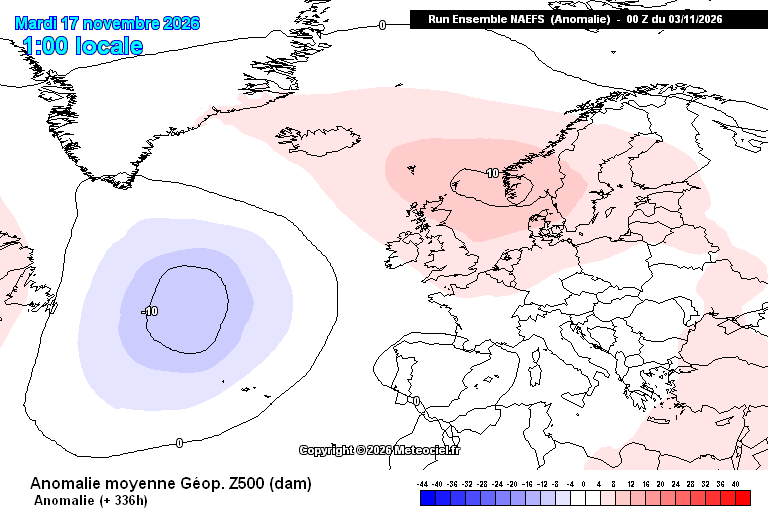
November
Plenty high pressure, more unsettled late on
High pressure to 9th, maybe something a touch unsettled 10-13th before more high pressure, particularly in the South
More widely unsettled possible late on, small chance of colder air, especially in North
#UKweather #LakeDistrict


MetJam retweeted

After recent swings between near-record highs and lows, the atmosphere has settled down again, with 1044.2 hPa at Tulloch Bridge on Monday marking the UK's highest November pressure since 1999
High pressure is now set to dominate through much of this week
MetJam retweeted

Today marks exactly 10 years since Hacker T. Dog delivered the greatest unscripted line in British television history.
"We're just normal men... We're just innocent men."
MetJam retweeted

Small Shortwave upper trough will dive South during the next 24 hrs around the Atlantic Ridge with a vorticity filamant associated with it, this will run into the rear of the existing 500mb trough over Central Europe and extend it west a little. This will serve to deepen the boundary layer over the SE of England and East Anglia with an increasing wind, more turbulant cloud base and showers in the SE. Despite the high pressure over Scotland by this time 1044mbs A Dover Strait shower train and Showers into Coastal East Anglia.
During Tuesday a further filament of vorticity will run west from Jutland and the flow will veer Easterly over much of the South. Feeling colder in the wind and fog will become more of a CuST problem with a mix of Cu St and breaks leading to some sunshine.
By Wednesday a large rex block will have established with 500mb ridge over Scotland and Cut off Low to the south of the block over Biscay.
The ridge sinks ESE into Europe thereafter and the vortex will round and move N so threat of showers and rain returning to the SW later in the week into the weekend but beyond that into next week there is great ensemble spread in solutions depending on how developments in the SW Atlantic develop and how much sub tropical moisture surges NE.


MetJam retweeted

Our analysis of damaging "straight-line" winds that impacted parts of S. Yorkshire + Lincolnshire on evening of Sunday 29 March 2026 has been published 📖
Meteorological setup in @RMetS "Weather" journal: rmets.onlinelibrary.wiley.co…
Detailed damage reports: torro.org.uk/research/event

MetJam retweeted
On Sun 29 March 2026, damaging winds occurred in South Yorks and Lincs associated with shallow convection just 3–4 km deep. Radial velocities of up to ~80mph were detected.
The event has been published as a Spotlight article in @RMetS journal "Weather": rmets.onlinelibrary.wiley.co…


MetJam retweeted

@MetJam_ @metoffice I chose to leave work at the wrong time. That one hell of a band of rain that just passed through Sunderland

MetJam retweeted
A weak tornado affected Portchester, Hampshire, just after midnight on 23 October, with a 1.6 km land track. It was associated with heavy showers that moved inland from the Channel, linked to Storm Austen. More details to follow after the analysis has concluded.

ALT Map of Portchester, Hampshire, showing damage points and debris fall recorded in the TORRO survey, with a 1 km scale bar and a locator inset of southern England.


MetJam retweeted
Hello,
We have seen a few reports of particularly intense, damaging winds, which occurred around midnight in Portchester and Gosport. If you have any information, including any photos of damage, we would like to hear from you.
torro.org.uk/severe-weather-…
~ Sarah

MetJam retweeted
The last of my #StormAusten video spam. Powerful gusts, but also a very strong sustained wind.
MetJam retweeted
Winds have ramped up significantly within the last hour with some powerful gusts of wind here in Hayle, Cornwall. Also a lot of power flashes, very frequent.
#StormAusten
MetJam retweeted
A busy day for our teams @metoffice with Storm #Austen expected to bring impacts to SW England and W/SW Wales early Friday, and then Storm #Boelo across more northern parts of the UK over the weekend... 🌀
youtube.com/watch?v=-xwVvTEa…


MetJam retweeted

⚠️ Storm Austen Update: A Channel Islands Red Wind Warning has been issued. Islanders should avoid outdoor activity on Friday morning where possible.
Information on Friday closures can be found here: bit.ly/4zFXTWk
Weather updates here: gov.je/weather

MetJam retweeted
The Met Office has named #StormBoelo
The storm is forecast to bring strong winds and heavy rain across the UK on Saturday
The strongest winds will be across Northern Ireland, Scotland and northern England
Stay #WeatherAware ⚠️