

Northeast Tennessee coverage on short and long range weather, 7-Day forecasts for the Tri-Cities, model discussion, etc. Snow is the best kind of weather.
Joined December 2020
- Tweets28.9K
- Following934
- Followers4.8K
- Likes20.8K





StormTrackerSacher retweeted

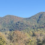
Looking across my neighbor's yard at the ridge above us contrasted with that blue sky, amazing colors!!

StormTrackerSacher retweeted

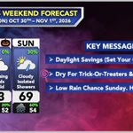
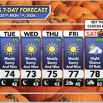
Here’s your latest Trick-or-Treat forecast! Good news: you won’t be needing the umbrella this year. However, you may want to keep a light jacket as temperatures will fall into the 50s after sunset.

ALT Halloween Saturday will be mostly cloudy with highs between 71 and 76 degrees. Saturday night remains cloudy with lows dropping to 51 to 57 degrees. Sunday continues mostly cloudy and cooler with highs from 65 to 70 degrees. Sunday night brings cloudy skies, lows between 49 and 55 degrees, and a slight chance of showers.
StormTrackerSacher retweeted

The most powerful weather software is now in your pocket 📱⛈️
The AguaceroWX iOS app is in open beta, and everything in the beta is totally free 🆓
How to get in 👇
1️⃣ Install TestFlight from the App Store
2️⃣ Open this link on your iPhone: testflight.apple.com/join/Ff…
3️⃣ Tap Accept, then Install
4️⃣ Open AguaceroWX and start exploring 🌀📡🛰️
Beta spots are limited for now, but we'll open it up more soon 🔓
Android is coming soon too 🤖

StormTrackerSacher retweeted

I’ll be live tonight to discuss the latest with our Polar Vortex disruption and the upcoming multi-day severe weather threat.
Hoping to hit the 10K sub milestone on YouTube🎉 Join me on TikTok or YouTube at around 8pm if you have any questions about the weather ahead!


StormTrackerSacher retweeted
UNREAL color in the mountains right now. Most vibrant leaves I've seen in years! 🍂🍁
📍Ridgecrest, NC


StormTrackerSacher retweeted

With Dolly Parton gone, the Red Baron employee has stepped up to unite all Americans


StormTrackerSacher retweeted

Man…
NOBODY wants to hear anything about severe weather potential. Lol
Got to get some Winter stuff going. That’s what the people want. It’s obvious with views on YouTube.
StormTrackerSacher retweeted

I feel like given all the talk about stratospheric warming and polar vortex disruption some things need to be clarified:
1. A SSW(sudden stratospheric warming) and potential subsequent reversal in winds associated with the stratospheric polar vortex DO NOT guarantee wave reflections back to the troposphere or coupling. It can have significant impacts should coupling/reflections to the lower atmosphere occur, but that is something that is still an unknown and will need to be observed in coming days and weeks. Wave reflection can have impacts sooner, coupling can take longer.
2. Notice how I said weeks… there is usually a lag period between the actual disruptive warming event/reversal itself and subsequent downward reflection and/or potential coupling. This can take time, and is still not a guarantee.
3. With the above being said this may have impacts on our pattern at 500 MB down the road come mid/late November, but right now that is TBD. In any case the Nino enhanced sub tropical jet will lead to increased storminess, with wetter and cooler potential for the southern tier of the United States as we move deeper into November, that’s just Nino climo.
So while this may be exciting for winter weather enthusiasts and while this event is extraordinary given the environment and time of year it is occurring, nothing is set in stone as of yet. Could this lead to a colder pattern later into November? Yes. Could wave propagation simply be absorbed by the stratosphere leaving a weakened vortex with little downward propagation/surface effects? Also yes. (The second scenario still doesn’t preclude downward coupling later down the road)
We know this will more likely than not significantly disrupt the polar vortex, but we still need to have some patience and observe downward coupling/wave propagation over the next 2-4 weeks. Canada is also going to remain quite warm during this time, so any true cold will need to originate via cross polar flow should we get enough polar blocking. Just several things to think about before we get either too hyped up, or too dismissive of this event at the moment.

StormTrackerSacher retweeted

Todays 00z is (by memory) the first run period so far, that all 3 main ensemble systems agree on a #polarvortex wind reversal and an official Stratospheric Warming event. The 2 main single-run models also agree on a reversal, while the AIFS remains the only one yet to show a wind reversal, likely limited by its own design, or time will tell.
While its clear that something is going to happen in the stratosphere, what people want to know is how it will change their daily weather. I think we are still not at a point where we can definitively say "ok THIS is what will change for you".
We all know the usual impacts following an SSW event in mid-winter, and it can greatly increase the chance colder air and snowfall across parts of the United States, Europe, and other mid-latitudes, at least on average.
But we are very early in the season, dealing with the earliest SSW event on record if verified, but we are also dealing with a most easterly based Super El Nino on record. This puts the atmosphere in a very unforgiving setup to find any typical SSW impact right now. Just something to keep in mind as the situation unfolds


StormTrackerSacher retweeted

My favorite time of the year... Everyone goin nuts about the #polarvortex so time for a quick ez explanation of what it actually is. The current buzz is "Sudden Stratospheric Warming" so that's included too. Super basic version!
StormTrackerSacher retweeted

As expected, it looks like we are really going to begin to setup in a classic El Niño driven pattern with an active storm track around the southern half of the CONUS. Here is the latest Euro Weeklies run, quite the signal. A very active next few months are ahead.
StormTrackerSacher retweeted

The Polar Vortex stuff could jack-up our preconceived thoughts on mid-November through mid-December.
Here is why
It isn’t like there is bottled up crazy cold temperatures sitting in waiting if we do get a split (so early in the season). Secondly, the question of, is the split going to be favorable for us in the US (the favorability is a huge factor to consider here)?
But let’s say the split occurs and let’s say that it is favorable for us. Then you get an issue with the December temperature anomaly forecasts. Not because something is wrong with physics, we just added another input because the atmosphere is dynamic, not stagnant. The atmosphere isn’t binary (yes or no).
Long story short, if the split occurs and it is favorable to us, December (primarily the first half) will be cooler than forecasted (key word is forecasted). If the split occurs and it is not favorable for us, December will be warmer than even forecasted.
So we wait
StormTrackerSacher retweeted


StormTrackerSacher retweeted
Remember to set your clocks back one hour this Saturday night. It's also a good time to check the batteries in smoke detectors and weather radios.

StormTrackerSacher retweeted
Hi guys
I was tired of missing cool sunsets so I made a bot and website to show sunset quality forecasts.
SkyGrade compares several recent runs of a high resolution weather model to grade every spot's sunrise and sunset from A+ to F, based on how much high cloud there is to catch the color, whether lower clouds block the light, and how much smoke or haze is in the air.


StormTrackerSacher retweeted

🚨 New PolarWx Model Viewer is live 🚨
It's been a while since my PolarWx model page got an upgrade - so today I'm releasing a new model viewer with a fully interactive and customizable layout, many more plots & models, and many new features.
polarwx.com/models/

StormTrackerSacher retweeted

Spring Mill State Park today 🍁
#fallcolors2026 @FoliageReport @ExploreFall @SCweather_wx @indywx @TrackerSacker @stormricker #INwx

